Chandigarh Masterplan 2031: Zone Check and Land Use Guide
Chandigarh Masterplan Preview
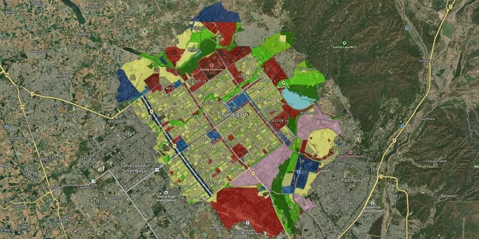
Try the Chandigarh Masterplan 2031 on the map
Sign in once and explore the layer for a full day.
- No card details needed
- Find nearby verified lands for sale
Overview
Knowing the Chandigarh masterplan zone classification of a plot is the single most important step before signing anything. The Chandigarh Master Plan 2031, prepared by the Chandigarh Administration, covers a planning area of 144 sq km comprising 60 sectors in the sectoral grid plus periphery pockets outside it. The plan is structured around the original Le Corbusier principles: residential sectors, working areas along Madhya Marg and Jan Marg, open spaces in Leisure Valley, and a road hierarchy of seven V-classes. This page covers the two critical legal traps specific to Chandigarh's land market, the growth corridors worth watching, and the exact steps to verify any parcel before committing funds.
Agricultural land outside Lal Dora and the Periphery Control Act trap that catches buyers in Chandigarh's villages
Chandigarh has a land regulation layer that does not exist in most other Indian cities: the Punjab New Capital (Periphery) Control Act, 1952. This Act prohibits any construction or commercial activity on agricultural land outside the lal dora (the traditional village boundary) in the periphery villages around Chandigarh UT, regardless of whether a seller markets that land as "residential plots" or "developed layout."
The enforcement record is unambiguous. When 13 villages were merged with the Chandigarh Municipal Corporation, the Chandigarh Administration confirmed that the Periphery Control Act continued to apply to all land outside lal dora in those villages. Illegal construction on agricultural land in these villages proceeded anyway, and demolitions followed. As recently as March 2026, the Punjab and Haryana High Court pulled up GMADA for 193 illegal structures in de-listed forest land across 15 villages adjacent to Chandigarh, with 35 demolition drives conducted in Mohali district alone in the preceding six months, removing approximately 450 unauthorised structures.
A second trap applies inside the sectoral grid. The CMP 2031 reserves all proposed residential, commercial, industrial, transportation, and public facility areas for development exclusively by the Chandigarh Administration or its undertakings. Private developers cannot develop these reserved zones without the Chandigarh Administration's sanction. This means that any agricultural land in the periphery pockets requires a formal Change of Land Use (CLU) certificate from the Department of Urban Planning before residential construction becomes legal. The CLU fee in Chandigarh is ₹5,000 for the first acre and ₹1,000 for each additional acre.
The table below shows the land use categories defined in the CMP 2031 and their key restrictions.
Land Use Zone
Permitted Development
Reserved for Administration?
CLU Required for Change?
Residential (Phases I, II, III sectors)
Housing per architectural controls
Yes
Not applicable to existing plots
Commercial (V4 streets, City Centre, Sub-City Centres)
Retail, offices, booths
Yes (new development)
Yes, if converting from residential
Industrial Area (Phases I and II)
Manufacturing, IT, ITES, warehousing
Partially
Yes, for a change to residential
Agriculture (Periphery pockets)
Bona fide agriculture only
No private construction
Yes, mandatory for any other use
Green / Open Space
Public recreation
Prohibited for private use
Not permissible
If a seller outside Lal Dora cannot show a valid CLU certificate issued by the Department of Urban Planning, the "residential plot" being offered is legally agricultural land, and any structure built on it faces demolition under the Periphery Control Act.
Sector 53, New Chandigarh, and the periphery pockets: three very different risk profiles for Chandigarh masterplan zone buyers
Within Chandigarh's planning area, location within or outside the sectoral grid determines not just price but the entire legal framework applicable to a purchase.
Inside the sectoral grid, the CMP 2031 confirms no change in the land use already defined in Phase I, Phase II, and Phase III sectors. Plots allotted by CHB or the Estate Office in sectors such as Sector 38W, Sector 45, Sector 47C, Sector 49, and Sector 56 are governed by established architectural controls. The Chandigarh Administration has allowed 28 categories of need-based changes in approximately 70,000 CHB units, covering internal alterations, additional balconies of up to 3 feet, and lift construction via the Online Building Plan Approval System (OBPAS). In January 2026, CHB announced the auction of approximately 10 acres of prime land in Sector 53 to private builders for residential apartments, with collector rates at ₹62 crore per acre. Sector 54 near the IT Park has 125 acres earmarked for a similar housing initiative.
The 17 periphery pockets outside the sectoral grid, covering a total of 3,082 vacant acres identified in the CMP 2031, present a categorically different situation. These pockets abut the Chandigarh–Ambala Road, the railway line, and various interstate boundaries. The plan describes large-scale unauthorised development having taken place in several pockets, specifically naming Riapur Khurd village as requiring strict enforcement and a comprehensive redevelopment plan before any further private development is permitted. New Chandigarh (Mullanpur) in adjacent Punjab falls under GMADA jurisdiction, not the UT administration, and is governed by Punjab RERA and GMADA regulations.
Zone / Corridor
CMP 2031 Status
Growth Driver
Primary Risk
Sectors 53-56 (Phase III)
Residential sectors in the sectoral grid
CHB auctions, IT Park proximity
CHB approval and OBPAS compliance
Manimajra / Dadu Majra
Residential, planned for redensification
Affordable housing, MC merger
Agricultural pockets are still active, Lal Dora ambiguity
Periphery Pockets 1-17
Mixed; residential in some, agriculture in others
CMP 2031 planned development
Periphery Control Act, CLU requirement
New Chandigarh (Mullanpur)
GMADA jurisdiction (outside UT)
GMADA-approved layouts
PLPA violations, demolition drives are active
The most misunderstood corridor is Manimajra and the villages recently merged with the MC Chandigarh. Buyers assume the MC merger means full residential rights. It does not. The Periphery Control Act remains in force on all agricultural land outside the lal dora in these villages, and the MC Commissioner has no jurisdiction to waive it.
Was this layer helpful?
Anything wrong, outdated, or missing we want to hear it.
For Land Owners & Agents
Looking to sell your land in Chandigarh?
I want to sell my land in Survey Numbers
10:32
Plz share your Land's location - We will list it on 1acre map, for Free.
10:32

For Land Buyers
Browse all verified lands & plots in Chandigarh
Every listing goes through our Preliminary Verification Process.
