Patna Masterplan
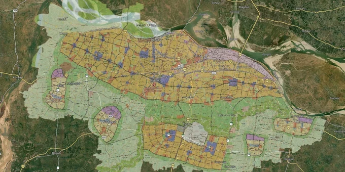
Patna Masterplan Preview
Try the Patna Masterplan on the map
Sign in once and explore the layer for a full day.
- No card details needed
- Find nearby verified lands for sale
Overview
Every plot in Patna has a zone. That zone is set by the Patna Master Plan 2031, prepared under Bihar's Urban Development and Housing Department, with consultancy by DCPL (Kolkata) and updated by CEPT (Ahmedabad). The plan covers Patna Municipal Corporation and a much larger Patna Planning Area spanning parts of Patna, Saran, and Vaishali districts. It was approved by the Bihar Cabinet in October 2016 and runs to 2031. What the zone says determines what you can build, whether you need conversion approval first, and whether a broker's pitch about a peripheral plot has any legal basis at all. This page cuts through the jargon on zones, documents, and the corridors where things are actually moving.
Fake Khatiyan, Agricultural Zone Traps, and Why Patna's PPA Peripheral Land Is High Risk
Patna has a land fraud problem, and it starts with one document. The Khatiyan is Bihar's record of rights: it tells you who owns a plot and under what terms. In 2024, the Patna High Court took up CR. WJC No.1703 of 2023 and found something that should stop any peripheral land buyer cold. The court flagged fabricated Khatiyan records in circle offices, with revised registers prepared without any underlying order sheets. The documents looked correct. The ownership trail simply did not exist. A registered sale deed in Patna does not guarantee a clean Khatiyan behind it. These are two separate checks, and skipping the second one is exactly how buyers end up in years of litigation over land they paid crores for.
The zone problem compounds the document problem. Large stretches of the Patna Planning Area (PPA) outside the Patna Municipal Corporation carry an Urban Agriculture or Village Settlement zone designation under the Master Plan 2031. Both require a formal Change of Land Use before any residential or commercial development can happen. Patna had no operational masterplan from 1981 to 2016, and during those 35 years, unplanned construction crept across agricultural and rural land across the city's periphery. Brokers selling those plots today rarely mention the CLU requirement. If a seller cannot produce the conversion approval, you are buying land that cannot legally be built on until the state approves it, which is not guaranteed.
The table below shows the principal zone types in the Patna Master Plan 2031 and the key risk attached to each.
Zone
Permitted Use
Conversion Required?
Common Risk
Residential (R1 / R2)
Housing, mixed residential
No, if permit obtained
Unapproved layouts in R2 periphery
Commercial (C1 / C2)
Retail, offices, mixed use
No, if within designated area
Misclassification by brokers
Urban Centre (UC)
Mixed high-density development
No
Speculation on unnotified UCs
Urban Agriculture / Village Settlement
Agricultural and rural residential only
Yes, CLU required for urban use
Sold as residential land without conversion
Conservation / Bio-Conservation
No private development permitted
Conversion not available
Riverbank and flood plain parcels
The most dangerous combination in Patna is a peripheral plot in a Village Settlement zone backed by a recently fabricated Khatiyan. Both conditions can pass a surface-level title check. The failure shows up only when construction begins and authorities arrive.
Danapur, Bihta, Phulwari Sharif: Where the Patna PPA Growth Corridors Are and What Still Has Risk
The Patna Master Plan 2031 was built around a multi-nuclei model, with Urban Centres proposed along key corridors to pull growth away from the congested PMC core. Three corridors are seeing the most real buyer activity.
Danapur and Khagaul are the western corridor. In June 2025, the Bihar cabinet expanded the municipal limits of Danapur, Khagaul, and Phulwari Sharif, pulling nine villages into Danapur alone, pushing its area to 23.14 sq km. That matters because it brings more land under formal civic planning jurisdiction and shrinks the grey area where uncontrolled peripheral development happens. The Danapur–Bihta elevated road, a 25 km NHAI project approved under the PM Package, had land acquisition substantially completed by late 2024, with construction actively underway as of 2025 targeting completion by September 2026, with the district collector's office running compensation camps. Land along that alignment is already priced as if the road exists.
Bihta is where speculative capital has moved. The proposed civil enclave at Bihta Air Force Station and an expanding industrial zone are the drivers. But here is what brokers selling Bihta land often leave out: Bihta is a community development (CD) block that only partially falls within the PPA boundary. Plots in the portions outside the PPA do not have the same development control certainty as land within the PMC or a formally notified Urban Centre. Buying in Bihta without confirming PPA inclusion is a bet on a policy outcome, not a guaranteed development right.
The table below maps each corridor and its current standing under the Patna Master Plan 2031.
Corridor / Locality
Zone Context (PMP 2031)
Growth Driver
Known Risk
Danapur–Khagaul
Conurbation; recently expanded municipal limits
Western urban corridor, railway connectivity
Legacy unapproved layouts in newly added villages
Phulwari Sharif
Partly PMC, partly expanded municipal
Airport adjacency, AIIMS Patna
Village Settlement Zone plots sold as residential
Bihta
Partially within PPA
Bihta civil enclave, NHAI road, industrial zone
Large portions outside PPA; development control uncertain
Patna Sadar / Core PMC
PMC area, full development control
Capital city core, commercial demand
High incidence of disputed Khatiyan and double-sales
Phulwari Sharif trips up buyers who see the airport and AIIMS Patna and assume the whole area has residential zone coverage. A meaningful portion of its land base sits in Village Settlement and Agriculture zone classification under the PMP 2031. Airport proximity does not change the zone. Check the specific survey number, not the postcode.
Was this layer helpful?
Anything wrong, outdated, or missing we want to hear it.
For Land Owners & Agents
Looking to sell your land in Bihar?
I want to sell my land in Bihar
10:32
Plz share your Land's location - We will list it on 1acre map, for Free.
10:32

For Land Buyers
Browse all verified lands & plots in Bihar
Every listing goes through our Preliminary Verification Process.
More Layers in Bihar
See all 7 layers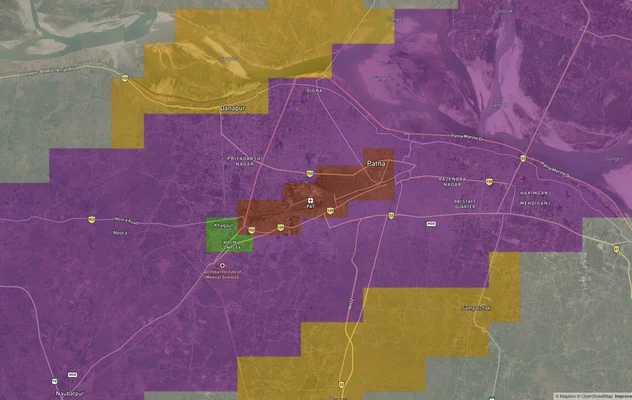
Patna Air Funnel Zones
View Patna Air Funnel Zones on a live map – check height clearance restrictions on any plot for free on 1acre.in. Patna ...
Gorakhpur - Siliguri Expressway
View Gorakhpur - Siliguri Expressway alignment as a live map overlay – check land acquisition risk and plot proximity fr...
Varanasi - Kolkata Expressway
View Varanasi - Kolkata Expressway alignment as a live map overlay – check land acquisition risk and plot proximity free...
More Layers in Bihar
Patna Air Funnel Zones
View Patna Air Funnel Zones on a live map – check height clearance restrictions on any plot for free on 1acre.in. Patna ...
Gorakhpur - Siliguri Expressway
View Gorakhpur - Siliguri Expressway alignment as a live map overlay – check land acquisition risk and plot proximity fr...
Varanasi - Kolkata Expressway
View Varanasi - Kolkata Expressway alignment as a live map overlay – check land acquisition risk and plot proximity free...