Patna Air Funnel Zones
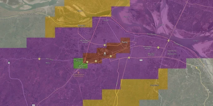
Patna Air Funnel Zones Preview
Try the Patna Air Funnel Zones on the map
Sign in once and explore the layer for a full day.
- No card details needed
- Find nearby verified lands for sale
Overview
Patna airport funnel zone restrictions apply to a 20 km radius around Jay Prakash Narayan Airport's aerodrome reference point, and they directly cap how tall any structure on your plot can be. The governing document is the Colour Coded Zoning Map (CCZM) prepared by the Airports Authority of India under GSR 751(E), 2015. It assigns every land parcel in the zone a permitted top elevation in meters AMSL. The airport sits at Patna City with a single runway oriented 07/25 (east-west).
The AMSL Trap: How Patna Airport Height Restrictions Catch Buyers Off Guard
Most buyers near Jay Prakash Narayan Airport focus on price per square foot. They miss the number that matters more: the AMSL ceiling printed on the CCZM grid covering their plot. That ceiling, not the building bylaws, determines how many floors you can actually build, and no amount of municipal approval from Patna Municipal Corporation overrides it.
Permitted Building Heights by Funnel Zone Surface (Patna)
The table below shows how permitted building height works across the key obstacle limitation surfaces around Patna airport's runway 07/25.
Zone Type
Distance from Runway
Height Rule
AAI NOC Required?
Inner Horizontal Surface
Within ~4 km of runway ends
Max ~45 m AGL
Yes, if CCZM grid is red
Approach / Funnel Surface
Along runway 07/25 axis, up to ~9 km
2% of distance from runway edge
Mandatory in all cases
Conical Surface
4–15 km from ARP
Gradient slopes upward at 5%
Depends on CCZM grid colour
Outer Zone
Beyond 15 km, within 20 km
Generally permissive; local bylaws apply
Required only if building exceeds CCZM elevation
Permitted height in the CCZM is stated as AMSL, not above ground level. Your actual allowable floors equal the CCZM elevation minus your site elevation. A plot at 54 m AMSL with a CCZM ceiling of 64 m AMSL allows only 10 m of building height, roughly three floors. Patna airport's runway 07/25 is oriented east-west, so the funnel zone bites hardest along the eastern and western axes: areas toward Phulwari Sharif on the west and Patna City on the east sit directly under approach paths. The Patna Secretariat's clock tower was formally flagged by AAI for violating approach surface limits, with a 17.5-metre height reduction requested. That is not an abstract regulatory concern; it is the practical reality of building anywhere near the Patna airport height restriction corridor.
Borjhar to Bihta: Which Patna Corridors the Funnel Zone Affects Most
The funnel zone is not uniformly bad for buyers. Its restrictions on building density suppress overcrowding in some corridors, keeping land prices lower than their connectivity would otherwise justify. The question is whether your plot sits in a suppressed-price zone that will stay suppressed or one with genuine upside once the regulatory picture clears.
The table below maps key Patna corridors against their airport constraint profile.
Corridor / Locality
Airport Distance
Constraint Level
Growth Driver
Key Risk
Phulwari Sharif
~2 km (western approach)
Very High (approach funnel)
Affordable land, road access
Severe height caps; multi-storey, difficult
Danapur
~4–6 km (northwest)
Moderate
Railway station, Patna Metro corridor
Check the individual CCZM grid; spot variation
Kankarbagh
~8.5 km (east-southeast)
Low-Moderate
Largest residential colony in Patna; PMC zone
Beyond critical funnel; bylaws dominate
Bihta
~20 km (southwest)
Minimal (new civil enclave)
Proposed Bihta airport civil enclave
Acquisition uncertainty; pre-enclave values speculative
Rajendra Nagar / Boring Road
~7–9 km (south)
Low
Patna Master Plan 2031 urbanization zone
Defence airport jurisdiction overlap possible; verify separately
Bihta is the most misunderstood corridor. The Airports Authority of India awarded a ₹459.99 crore contract for the civil enclave at Bihta Air Force Station, with construction beginning April 2025. Land within 5 km of the proposed terminal has attracted investor interest, but no CCZM for Bihta has yet been published. Buying land close to the Bihta terminal site before that map is released carries the same regulatory opacity that Patna city buyers have faced for decades at Jay Prakash Narayan Airport.
Was this layer helpful?
Anything wrong, outdated, or missing we want to hear it.
For Land Owners & Agents
Looking to sell your land in Bihar?
I want to sell my land in Bihar
10:32
Plz share your Land's location - We will list it on 1acre map, for Free.
10:32

For Land Buyers
Browse all verified lands & plots in Bihar
Every listing goes through our Preliminary Verification Process.
More Layers in Bihar
See all 7 layers
Patna Masterplan
View Patna Masterplan as a live map overlay – check any plot's land use zone for free on 1acre.in. Patna masterplan land...
Gorakhpur - Siliguri Expressway
View Gorakhpur - Siliguri Expressway alignment as a live map overlay – check land acquisition risk and plot proximity fr...
Varanasi - Kolkata Expressway
View Varanasi - Kolkata Expressway alignment as a live map overlay – check land acquisition risk and plot proximity free...
More Layers in Bihar
Patna Masterplan
View Patna Masterplan as a live map overlay – check any plot's land use zone for free on 1acre.in. Patna masterplan land...
Gorakhpur - Siliguri Expressway
View Gorakhpur - Siliguri Expressway alignment as a live map overlay – check land acquisition risk and plot proximity fr...
Varanasi - Kolkata Expressway
View Varanasi - Kolkata Expressway alignment as a live map overlay – check land acquisition risk and plot proximity free...