
Bhu Naksha Haryana: the khasra on the cadastral map
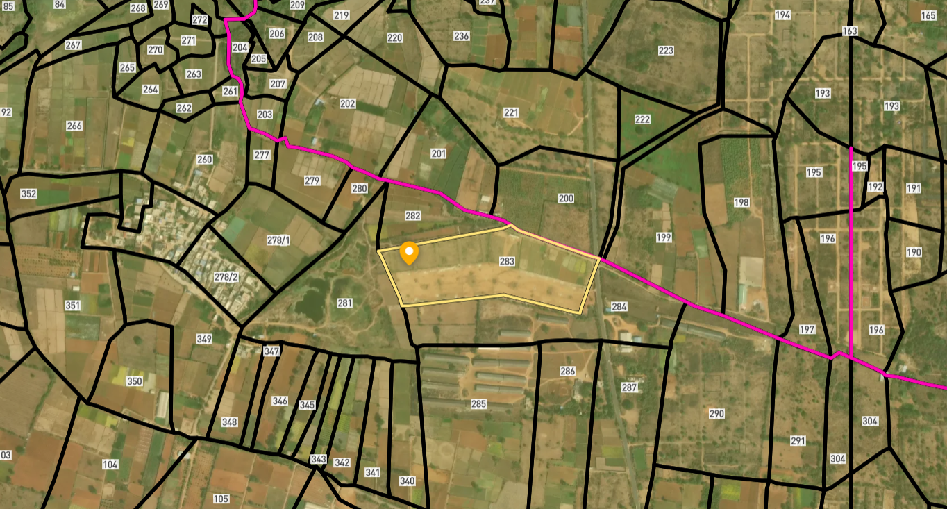
The cadastral map on Jamabandi Haryana places a khasra among its neighbours and shows how the parcel sits in the field pattern. In a state that went through chak consolidation, the map a buyer sees is the post-consolidation layout, and confirming that the drawn boundary matches the ground is the check that follows. The map locates; the Fard sizes; the ground decides the edge.
What the Haryana cadastral map shows after consolidation
Definition
The Bhu Naksha on Jamabandi at jamabandi.nic.in shows the post-consolidation khasra as a shape among its neighbours in the village field pattern. It places the plot and identifies adjoining khasras and roads, but it is a drawn record, not a survey. The area comes from the Fard, and the exact boundary is confirmed on the ground. In a consolidated village the drawn boundary reflects the chak layout, not the original strip pattern. Confirm the live map on jamabandi.nic.in before you rely on it.
The cadastral map on Jamabandi tells a buyer where a khasra sits: which road reaches it, which khasras adjoin it and how it is shaped in the village layout. For a buyer checking a Haryana plot from outside the state, or one who wants to verify that the khasra is not landlocked or oddly positioned, the map is the first spatial reality check. It is available on the same platform as the Fard, so the area from the record and the shape from the map can be read together.
In a consolidated village the map shows the post-chak layout. The original strips that were pooled and re-allotted are now drawn as compact blocks, and the khasra number shown is the post-consolidation one. A buyer who checks the map is checking the consolidated layout, which is the correct picture for a current transaction, but a boundary that looks different from what the seller described may signal that the seller is still thinking in terms of a pre-consolidation strip.
The map's limits are the same in Haryana as elsewhere. It draws a shape from the cadastral record rather than from a fresh measurement, and the drawn edge is an approximation of the boundary as recorded, not a precise survey. A khasra that draws well on the map still earns a walk to confirm the edge, access route and neighbours are as shown. And the map says nothing about ownership or shares, which are the Fard's domain. Together, the map's shape and the Fard's area describe one plot; used alone, each leaves the other's question unanswered.
How to open the Bhu Naksha on Jamabandi Haryana
Setting the village and the khasra number correctly is the whole of it; the reconciliation with the Fard follows.
On Jamabandi
Haryana Bhu Naksha: the map and the Fard
Let the map place the khasra; let the Fard give the area; let the ground settle the edge.
| The map shows | It does not show | Settled by |
|---|---|---|
| Where the khasra sits | The exact measured edge | Walking the boundary |
| Which khasras adjoin | Area or share | The Fard |
| Whether a road reaches it | A right of way in use | Confirming on the ground |
| The post-consolidation layout | The old pre-chak shape | The old khasra record |
| A plot's position | Ownership | The Fard and the deed |
Common Haryana Bhu Naksha issues, and the fix
Four map confusions in Haryana.
Reading a Haryana boundary after consolidation
Chak consolidation changed where khasras sit on the ground, not just their numbers. A post-consolidation khasra now occupies a compact block rather than a scattered strip, and the map reflects that new position. A buyer who checks the map is checking the current layout, which is the one that matters for a purchase, but a boundary walk is still the step that settles the edge, because the cadastral lines are drawn from the record and not surveyed afresh. The map's job in Haryana is to expose the spatial questions the Fard leaves unanswered: is the khasra reached by a road, does it sit where the seller implied, are the neighbours what the Fard describes. Catching those on screen, and reconciling the shape against the Fard area, is cheaper than finding the mismatch after possession. Its limits are the cadastral record and the one question it answers; for size, shares and title, the Fard and the deed sit alongside.
Survey Numbers View on Map Boundaries and numbers come from published state cadastral records. See all map layers.
Looking to sell your land in Haryana?

Browse 200+ verified lands & plots in Haryana
Frequently asked questions
Where do I view the Bhu Naksha for Haryana?
Does the Bhu Naksha show the post-consolidation layout?
Why reconcile the map with the Fard?
Are the map boundaries exact?
Does the map show ownership?
Is the Haryana map free to view?
Other Related Guides
Jamabandi Haryana
Every Haryana land record service in one place, mapped for buyers.
Read guide →Property Tax Haryana 2026: Complete Guide for Land Buyers
Check property tax dues and get Nil Dues Certificate in Haryana before buying. Pay online via NDC portal, avoid inheriting arrears. Full buyer guide 2026.
Read guide →Intkal Mutation Haryana 2026: Complete Buyer's Guide
Learn how to check and verify Intkal Mutation in Haryana 2026. Full 30-year chain guide, jamabandi.nic.in steps, common risks, and Tehsildar tips for land buyers.
Read guide →Jamabandi Haryana 2026: Complete Guide for Land Buyers
Check Jamabandi Haryana online at jamabandi.nic.in. Verify seller name, Khasra, Khewat, mutation status before buying land. Full buyer guide 2026.
Read guide →Khasra Girdawari Haryana 2026: Complete Guide for Land Buyers
Check Khasra Girdawari Haryana before buying land. Verify land use, crop status, and NA conversion via jamabandi.nic.in. Full buyer guide 2026.
Read guide →Legal Heir Certificate Haryana 2026: Complete Step-by-Step Guide
Learn how to get a Legal Heir Certificate in Haryana in 2026. Covers Antyodaya SARAL online process, documents, fees, Patwari verification, and why all heirs must consent before sale.
Read guide →