Itanagar Masterplan 2031: Zone Check and Land Use Guide
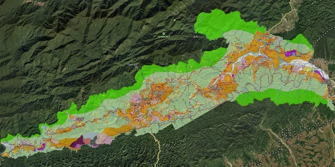
Itanagar Masterplan Preview
Try the Itanagar Masterplan 2031 on the map
Sign in once and explore the layer for a full day.
- No card details needed
- Find nearby verified lands for sale
Overview
The Itanagar Capital Region Masterplan 2031 is the operative land use framework for a 271 sq km planning area administered by the Itanagar Planning Authority (IPA) under the Arunachal Pradesh Urban and Country Planning Act, 2007. The plan covers Itanagar, Naharlagun, Banderdewa, Nirjuli, Karsingsa, Emchi, Doimukh, and 14 other settlements. Every plot in this planning area requires a mandatory development permission from the IPA before any construction or change of use. This layer is available to Premium subscribers on 1acre and maps the full IMP 2031 zone boundary for the ICR.
Forest Land, Section 29, and the Traps That Catch Buyers in the Itanagar Capital Region Masterplan 2031 Zone
Two regulatory traps operate simultaneously in the ICR, and neither of them appears on a standard sale agreement. The first is procedural: Section 28 of the AP Urban and Country Planning Act, 2007, makes it illegal to use or develop any land in the planning area in a manner that does not conform to the Development Plan. Section 29 goes further, prohibiting any development whatsoever without first obtaining development permission from the Itanagar Planning Authority. This applies to every plot within the IMP 2031 zone, regardless of what a broker tells you about existing structures or historic use. Brokers operating in Naharlagun and Bank Tinali frequently present informal constructions as evidence of permitted use. They are not.
The second trap is geographic and carries long-term title risk. In 1979, the Government of Arunachal Pradesh declared the Itanagar Capital Region ,covering Itanagar, Naharlagun, Nirjuli, and Banderdewa ,as falling within the Durpong Reserved Forest and Wildlife Sanctuary. As of June 2025, residents of notified villages and colonies within the ICR could not obtain Land Possession Certificates (LPCs) without a No Objection Certificate from the forest department. The Banderdewa Circle Border Committee has formally appealed to the Chief Minister to remove this requirement, but no de-reservation order has been issued. A plot in Banderdewa or Nirjuli without a clean LPC is a plot with a title cloud, regardless of how many generations have occupied it.
The table below maps the two key regulatory hurdles to the specific localities and documents each affects.
Regulatory Trap
Specific ICR Localities Affected
Document to Demand
Consequence of Skipping
Development permission under Section 29, AP UCP Act 2007
All localities within 271 sq km IMP 2031 planning area
IPA-issued development permission order
Structure treated as unauthorized; demolition risk
Durpong Reserved Forest / LPC without forest NOC
Banderdewa, Nirjuli, Naharlagun, Itanagar
LPC + forest department NOC
Title cloud; resale blocked; LPC disputes
If a seller cannot produce both an IPA development permission and a clean LPC with forest NOC clearance for plots in the affected corridors, stop the transaction there.
Naharlagun, Banderdewa, and the Hollongi Corridor: Where IMP 2031 Meets Real ICR Land Values
The ICR land market runs on two converging growth axes: the NH-415 corridor connecting Banderdewa, Naharlagun, and Itanagar, and the southward Hollongi corridor anchored by Donyi Polo Airport, which covers 320 hectares and was inaugurated in November 2022. Land prices in prime localities like Naharlagun, Chimpu, and Bank Tinali have crossed Rs 1 crore per 1,000 square metres, with semi-urban areas like Banderdewa and Lekhi showing steep appreciation driven by the airport and administrative expansion. These are not speculative projections ,they are documented price levels reported in 2025 with no regulatory index in place to stabilise them.
The table below ranks the active ICR corridors by investment readiness, not headline price.
Corridor / Locality
Primary Demand Driver
Investment Readiness
Known Risk Under IMP 2031
Naharlagun, Bank Tinali
Government offices, Gauhati HC bench, rail connectivity
High
LPC forest NOC requirement; limited new supply
Chimpu
Administrative and residential concentration
High
Steep prices; limited land parcels
Banderdewa
NH-415 gate, Donyi Polo Airport proximity, ILP checkpoint
Medium
Durpong forest title risk; LPC disputes active
Nirjuli, Karsingsa
ICR fringe growth, Hollongi access
Medium
Forest NOC requirement; IMP 2031 fringe compliance uncertain
Lekhi, Emchi
Semi-urban appreciation
Low to Medium
Informal transactions, no RERA, outdated circle rates
The most misread corridor is Banderdewa. Airport proximity is real and NH-415 connectivity is proven, but the Durpong forest NOC issue remains unresolved as of mid-2025. Land transactions in Banderdewa frequently occur informally or through power of attorney, bypassing official registration channels entirely. Arunachal Pradesh has no RERA. The Land Revenue Department's circle rates are acknowledged to be outdated and do not reflect market prices, which means buyers have no independent benchmark and no state regulator to appeal to if a transaction goes wrong. For any Banderdewa or Nirjuli plot, formal registration through the Land Settlement and Records Act and a verified LPC with forest clearance are non-negotiable, not optional.
Was this layer helpful?
Anything wrong, outdated, or missing we want to hear it.
For Land Owners & Agents
Looking to sell your land in Arunachal Pradesh?
I want to sell my land in Arunachal Pradesh
10:32
Plz share your Land's location - We will list it on 1acre map, for Free.
10:32

For Land Buyers
Browse all verified lands & plots in Arunachal Pradesh
Every listing goes through our Preliminary Verification Process.