
Map Layers in Uttar Pradesh
Understand how zoning, planning, and regulations shape real estate opportunities across Uttar Pradesh.

38 Live · Last updated 16 Nov 2026
Explore by City:
Explore by City:
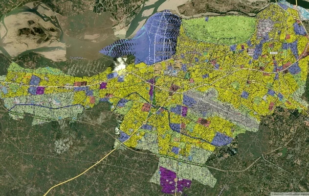
Ayodhya Masterplan
View Ayodhya Masterplan as a live map overlay – check any plot's land use zone for free on 1acre.in. Ayodhya masterplan ...
Lucknow Masterplan
View Lucknow Masterplan as a live map overlay – check any plot's land use zone for free on 1acre.in. Lucknow masterplan ...
Varanasi Masterplan
View Varanasi Masterplan as a live map overlay – check any plot's land use zone for free on 1acre.in. VDA Master Plan 20...
Ayodhya Ring Road: Map, Status, Land Buying
Ayodhya ring road project map, route and October 2026 status for the 67.57 km NHAI bypass, plus Gonda ring road links an...
Kanpur Ring Road Map: Route, Villages and Latest Status
Kanpur Ring Road map: the route around the city, villages on the alignment and the latest NHAI progress by stretch, then...
Lucknow Outer Ring Road (Kisan Path): Map, Route
Lucknow Outer Ring Road (Kisan Path, NH-230) route map, roads it crosses and villages covered, then the LDA zone and UP ...
Prayagraj Ring Road
View Prayagraj Ring Road alignment as a live map overlay – check land acquisition risk and plot proximity free on 1acre....
Agra - Gwalior Expressway
View Agra - Gwalior Expressway alignment as a live map overlay – check land acquisition risk and plot proximity free on ...
Ambala - Shamli Expressway
View Ambala - Shamli Expressway alignment as a live map overlay – check land acquisition risk and plot proximity free on...
Bundelkhand Expressway
View the Bundelkhand Expressway corridor on a live map overlay – check zoning, approvals and acquisition risk free on 1a...
Delhi Dehradun Expressway Map: UP Exits, Land
Delhi-Dehradun Expressway route map in UP: entry and exit points, the NH-709B number and phase status as of October 2026...
Delhi-Meerut Expressway
View the Delhi-Meerut Expressway corridor on a live map overlay – check zoning, approvals and acquisition risk free on 1...
EPE Route Map: Eastern Peripheral Expressway Exits and Land
Eastern Peripheral Expressway (EPE) route from Kundli to Palwal, exits at Baghpat, Duhai, Dasna, Dadri, Sirsa and Farida...
Ganga Expressway Map: Kanpur Route and Status
Ganga Expressway route map from Meerut to Prayagraj, the 12 districts it passes, how Kanpur joins it in Unnao, and land ...
Ghazipur Ballia Greenfield Expressway Route Map
Ghazipur-Ballia-Manjhi Ghat greenfield expressway route map, villages and October 2026 status by package, then the land ...
Gorakhpur - Siliguri Expressway
View Gorakhpur - Siliguri Expressway alignment as a live map overlay – check land acquisition risk and plot proximity fr...
Gorakhpur Link Expressway Route Map and Status
Gorakhpur Link Expressway route map: 91.35 km from Jaitpur on NH-27 to the Purvanchal Expressway at Salarpur, opening st...
Lucknow Kanpur Expressway (Awadh, NE-6): Route Map & Status
Lucknow Kanpur Expressway (Awadh, NE-6) route map, six entry and exit points and October 2026 toll and repair status, th...
Noida Expressway
View the Noida Expressway corridor on a live map overlay – check zoning, approvals and acquisition risk free on 1acre.in...
Purvanchal Expressway Map: Route, Districts and Land Guide
Purvanchal Expressway route and location on a live map: 340.8 km from Chand Sarai, Lucknow to Ghazipur across nine distr...
Varanasi - Kolkata Expressway
View Varanasi - Kolkata Expressway alignment as a live map overlay – check land acquisition risk and plot proximity free...
Yamuna Expressway
View the Yamuna Expressway corridor on a live map overlay – check zoning, approvals and acquisition risk free on 1acre.i...
Faizabad Road
View the Faizabad Road corridor on a live map overlay – check zoning, approvals and acquisition risk free on 1acre.in.
Farrukhabad Link Expressway Land Buying: Status and Route
Farrukhabad Link Expressway land buying decisions rest on a project that remains at an early planning stage even though ...
# Gorakhpur Bypass: Alignment, Land Acquisition Disputes and Growth Corridors
The 26.6 km greenfield stretch crosses 26 revenue villages from Maniram to Koni. Acquisition disputes and growth corrido...
Kanpur - Kabrai Highway
View Kanpur - Kabrai Highway alignment as a live map overlay – check land acquisition risk and plot proximity free on 1a...
Kanpur Road Lucknow Map: Location and LDA Land Guide
Kanpur Road in Lucknow runs from Alambagh past Amausi airport to Sarojini Nagar and Bani. See the localities, then the L...
Shamli-Gorakhpur Expressway: What to Check Before You Buy Land Nearby
The Shamli-Gorakhpur Expressway land records question comes with a real-time warning attached, one worth reading closely...
Ayodhya Air Funnel Zones
View Ayodhya Air Funnel Zones on a live map – check height clearance restrictions on any plot for free on 1acre.in. Ayod...
Lucknow Air Funnel Zones
View Lucknow Air Funnel Zones on a live map – check height clearance restrictions on any plot for free on 1acre.in. Luck...
IAF Air Funnel Zones - Bareilly
View the Bareilly air funnel zone around Trishul Air Base on a live map — check height clearance and NOC restrictions on...
IAF Air Funnel Zone Ghaziabad: Height Rules
View the Ghaziabad air funnel zone on a live map. Check AAI height clearance and Works of Defence Act NOC rules before b...
IAF Air Funnel Zone Gorakhpur: Height Rules
View the Gorakhpur air funnel zone on a live map. Check AAI height clearance and Works of Defence Act NOC rules before b...
IAF Air Funnel Zone Kanpur: Height Rules
View the Kanpur air funnel zone on a live map. Check AAI height clearance and Works of Defence Act NOC rules before buyi...
Lucknow Bakshi Ka Talab Air Funnel Zone Height Guide
View the Lucknow Bakshi Ka Talab Air Funnel Zone on a live map — check height clearance restrictions on any plot for fre...
IAF Air Funnel Zones - Prayagraj
View the Bamrauli air funnel zone Prayagraj on a live map — check height clearance and NOC restrictions on any plot for ...
Kashi Vishwanath Corridor
View the Kashi Vishwanath Corridor corridor on a live map overlay – check zoning, approvals and acquisition risk free on...
Khasra & Khatauni: Find Survey Numbers in Uttar Pradesh | 1acre.in
Free land records: Look up khasra, khatauni, and survey numbers in UP. Use UP Bhulekh or Bhu Naksha map on 1acre.in.
Don't see what you were looking for?
We're adding new masterplans, expressways and zoning layers every week. Tell us what you need next.
IAF Layers
6 layers
IAF Air Funnel Zones - Bareilly
View the Bareilly air funnel zone around Trishul Air Base on a live map — check height clearance and NOC restrictions on...
IAF Air Funnel Zone Ghaziabad: Height Rules
View the Ghaziabad air funnel zone on a live map. Check AAI height clearance and Works of Defence Act NOC rules before b...
IAF Air Funnel Zone Gorakhpur: Height Rules
View the Gorakhpur air funnel zone on a live map. Check AAI height clearance and Works of Defence Act NOC rules before b...
IAF Air Funnel Zone Kanpur: Height Rules
View the Kanpur air funnel zone on a live map. Check AAI height clearance and Works of Defence Act NOC rules before buyi...
Lucknow Bakshi Ka Talab Air Funnel Zone Height Guide
View the Lucknow Bakshi Ka Talab Air Funnel Zone on a live map — check height clearance restrictions on any plot for fre...
IAF Air Funnel Zones - Prayagraj
View the Bamrauli air funnel zone Prayagraj on a live map — check height clearance and NOC restrictions on any plot for ...

IAF Air Funnel Zones - Bareilly
View the Bareilly air funnel zone around Trishul Air Base on a live map — check height clearance and NOC restrictions on...
IAF Air Funnel Zone Ghaziabad: Height Rules
View the Ghaziabad air funnel zone on a live map. Check AAI height clearance and Works of Defence Act NOC rules before b...
IAF Air Funnel Zone Gorakhpur: Height Rules
View the Gorakhpur air funnel zone on a live map. Check AAI height clearance and Works of Defence Act NOC rules before b...
Kanpur Ring Layers
5 layers
Kanpur Ring Road Map: Route, Villages and Latest Status
Kanpur Ring Road map: the route around the city, villages on the alignment and the latest NHAI progress by stretch, then...
Ganga Expressway Map: Kanpur Route and Status
Ganga Expressway route map from Meerut to Prayagraj, the 12 districts it passes, how Kanpur joins it in Unnao, and land ...
Lucknow Kanpur Expressway (Awadh, NE-6): Route Map & Status
Lucknow Kanpur Expressway (Awadh, NE-6) route map, six entry and exit points and October 2026 toll and repair status, th...
Kanpur - Kabrai Highway
View Kanpur - Kabrai Highway alignment as a live map overlay – check land acquisition risk and plot proximity free on 1a...
Kanpur Road Lucknow Map: Location and LDA Land Guide
Kanpur Road in Lucknow runs from Alambagh past Amausi airport to Sarojini Nagar and Bani. See the localities, then the L...
Kanpur Ring Road Map: Route, Villages and Latest Status
Kanpur Ring Road map: the route around the city, villages on the alignment and the latest NHAI progress by stretch, then...
Ganga Expressway Map: Kanpur Route and Status
Ganga Expressway route map from Meerut to Prayagraj, the 12 districts it passes, how Kanpur joins it in Unnao, and land ...
Lucknow Kanpur Expressway (Awadh, NE-6): Route Map & Status
Lucknow Kanpur Expressway (Awadh, NE-6) route map, six entry and exit points and October 2026 toll and repair status, th...
Ayodhya Layers
3 layers
Ayodhya Masterplan
View Ayodhya Masterplan as a live map overlay – check any plot's land use zone for free on 1acre.in. Ayodhya masterplan ...
Ayodhya Ring Road: Map, Status, Land Buying
Ayodhya ring road project map, route and October 2026 status for the 67.57 km NHAI bypass, plus Gonda ring road links an...
Ayodhya Air Funnel Zones
View Ayodhya Air Funnel Zones on a live map – check height clearance restrictions on any plot for free on 1acre.in. Ayod...
Ayodhya Masterplan
View Ayodhya Masterplan as a live map overlay – check any plot's land use zone for free on 1acre.in. Ayodhya masterplan ...
Ayodhya Ring Road: Map, Status, Land Buying
Ayodhya ring road project map, route and October 2026 status for the 67.57 km NHAI bypass, plus Gonda ring road links an...
Ayodhya Air Funnel Zones
View Ayodhya Air Funnel Zones on a live map – check height clearance restrictions on any plot for free on 1acre.in. Ayod...
Lucknow Layers
3 layers
Lucknow Masterplan
View Lucknow Masterplan as a live map overlay – check any plot's land use zone for free on 1acre.in. Lucknow masterplan ...
Lucknow Outer Ring Road (Kisan Path): Map, Route
Lucknow Outer Ring Road (Kisan Path, NH-230) route map, roads it crosses and villages covered, then the LDA zone and UP ...
Lucknow Air Funnel Zones
View Lucknow Air Funnel Zones on a live map – check height clearance restrictions on any plot for free on 1acre.in. Luck...
Lucknow Masterplan
View Lucknow Masterplan as a live map overlay – check any plot's land use zone for free on 1acre.in. Lucknow masterplan ...
Lucknow Outer Ring Road (Kisan Path): Map, Route
Lucknow Outer Ring Road (Kisan Path, NH-230) route map, roads it crosses and villages covered, then the LDA zone and UP ...
Lucknow Air Funnel Zones
View Lucknow Air Funnel Zones on a live map – check height clearance restrictions on any plot for free on 1acre.in. Luck...
Gorakhpur Layers
2 layers
Gorakhpur Link Expressway Route Map and Status
Gorakhpur Link Expressway route map: 91.35 km from Jaitpur on NH-27 to the Purvanchal Expressway at Salarpur, opening st...
# Gorakhpur Bypass: Alignment, Land Acquisition Disputes and Growth Corridors
The 26.6 km greenfield stretch crosses 26 revenue villages from Maniram to Koni. Acquisition disputes and growth corrido...
Gorakhpur Link Expressway Route Map and Status
Gorakhpur Link Expressway route map: 91.35 km from Jaitpur on NH-27 to the Purvanchal Expressway at Salarpur, opening st...
# Gorakhpur Bypass: Alignment, Land Acquisition Disputes and Growth Corridors
The 26.6 km greenfield stretch crosses 26 revenue villages from Maniram to Koni. Acquisition disputes and growth corrido...
Varanasi Layers
2 layers
Varanasi Masterplan
View Varanasi Masterplan as a live map overlay – check any plot's land use zone for free on 1acre.in. VDA Master Plan 20...
Varanasi - Kolkata Expressway
View Varanasi - Kolkata Expressway alignment as a live map overlay – check land acquisition risk and plot proximity free...
Varanasi Masterplan
View Varanasi Masterplan as a live map overlay – check any plot's land use zone for free on 1acre.in. VDA Master Plan 20...
Varanasi - Kolkata Expressway
View Varanasi - Kolkata Expressway alignment as a live map overlay – check land acquisition risk and plot proximity free...
Agra Layers
1 layer
Ambala Layers
1 layer
Bundelkhand Layers
1 layer
Delhi-Dehradun Layers
1 layer
Delhi-Meerut Layers
1 layer
Eastern Peripheral Layers
1 layer
Faizabad Layers
1 layer
Farrukhabad Layers
1 layer
Kashi Vishwanath Layers
1 layer
Khasra & Layers
1 layer
Noida Layers
1 layer
Prayagraj Layers
1 layer
Purvanchal Layers
1 layer
Shamli Gorakhpur Layers
1 layer
Yamuna Layers
1 layer
Across Uttar Pradesh
2 layers
Ghazipur Ballia Greenfield Expressway Route Map
Ghazipur-Ballia-Manjhi Ghat greenfield expressway route map, villages and October 2026 status by package, then the land ...
Gorakhpur - Siliguri Expressway
View Gorakhpur - Siliguri Expressway alignment as a live map overlay – check land acquisition risk and plot proximity fr...
Ghazipur Ballia Greenfield Expressway Route Map
Ghazipur-Ballia-Manjhi Ghat greenfield expressway route map, villages and October 2026 status by package, then the land ...
Gorakhpur - Siliguri Expressway
View Gorakhpur - Siliguri Expressway alignment as a live map overlay – check land acquisition risk and plot proximity fr...
Don't see what you were looking for?
We're adding new masterplans, expressways and zoning layers every week. Tell us what you need next.