Bhopal Masterplan 2031: BDA Zone Check and Land Use Guide
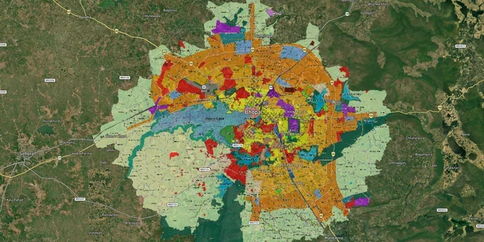
Bhopal Masterplan Preview
Try the Bhopal Masterplan 2031 on the map
Sign in once and explore the layer for a full day.
- No card details needed
- Find nearby verified lands for sale
Overview
The Bhopal masterplan 2031 land zone framework, prepared by the Directorate of Town and Country Planning (DT&CP) under the Madhya Pradesh Nagar Tatha Gram Nivesh Adhiniyam 1973, covers 1,016.90 sq. km across 248 villages. Released in June 2023 after an 18-year gap (draft status as of March 2026 — see FAQ 8 for current approval position), it replaces the expired Bhopal Development Plan (BDP) 2005. The plan introduces eight sub-cities, a Transit Oriented Development (TOD) corridor of 100 m width along metro lines, and hard construction bans around Kerwa Dam and Upper Lake catchment areas. This page explains the zone rules, regulatory traps, and the corridors where zone classification directly affects what you can build and what you cannot.
Zone Traps in Bhopal: Green Belt Reclassification and the Agricultural Diversion Trap
Two regulatory traps have already caught buyers in Bhopal. Both are written into the BDP 2031, and neither is visible without checking the Directorate of Town and Country Planning (DTCP) zone map against the revenue record.
The table below shows the four zone types most commonly misread by buyers and brokers in Bhopal.
Zone
Permitted Use
Requires Conversion?
Common Misrepresentation
Residential General (RG)
Residential; mixed use only on 18 m+ roads
Not applicable if already residential zone
Marketed as mixed-use on narrow colony roads
Low Density Residential (LDR)
Low-density residential; Floor Area Ratio (FAR) 1:0.06 (restored from 1:0.75 proposal)
No, but FAR strictly limited
Sold near Kerwa Dam as buildable; construction now banned
Green Belt / Forest
No private construction; even government structures barred near Kaliasot-Kerwa
No conversion permitted
Plots near Ratapani corridor sold as residential
TOD Corridor (100 m along metro)
Mixed use, higher FAR via Premium FAR or Transferable Development Rights (TDR)
No, but additional FAR requires Premium FAR payment or TDR
Marketed as automatic high-FAR zone without premium charge
The first trap is the Kerwa Dam green belt reversal. The draft BDP 2031 initially proposed 51.66 hectares near Kerwa Dam as Low Density Residential. The amended final plan reversed this, retaining it as green belt. Anyone who purchased based on the draft zoning now holds land with zero construction potential. The second trap is agricultural diversion. Buying agricultural land in Bhopal and converting it to residential requires a No Objection Certificate from DT&CP, payment of diversion charges under Section 172(1) of the MP Land Revenue Code 1959, and confirmation that the plot's zone in the masterplan is designated for residential use. Brokers routinely skip the masterplan check and push diversion as a formality. If the zone is green belt or forest, diversion approval will not be granted. Check the DTCP zone map before you sign anything.
Misrod to Mandideep and the Metro Corridor: Bhopal's Investable Land Zones in 2025-2031
Two categories of corridor exist in the BDP 2031 map: sub-city expansion zones with genuine residential demand, and metro-adjacent TOD corridors where land prices have already moved ahead of infrastructure delivery.
The table below shows the five corridors where BDP 2031 zone classification directly drives or restricts land value.
Corridor / Locality
BDP 2031 Zone
Growth Driver
Known Risk
Misrod towards Mandideep
New sub-city designation
Industrial demand from Govindpura, Bagroda, Mandideep within 15 km
Agricultural diversion required before residential development
Karond (Orange Line metro corridor)
TOD Corridor, 100 m either side of metro
Orange Line Priority Corridor (AIIMS to Subhash Nagar, 6.225 km) commercial ops 21 Dec 2025; full Orange Line (14.99 km to Karond) under construction, Phase 1 completion expected 2027; guideline rates proposed up from Rs 15,000 to Rs 50,000 per sq m near metro
Premium FAR payment required for density; not automatic
Narsinghgarh (Airport) Road
New sub-city designation
Airport proximity; new sub-city status in BDP 2031
Infrastructure delivery timeline uncertain
Chola Road corridor
New sub-city designation
Expansion zone between existing BHEL Extension and Misrod sub-cities
Currently underdeveloped; no confirmed infrastructure schedule
Kerwa / Upper Lake buffer
Green Belt / Forest / Wetland
None for residential buyers
Hard construction ban; BDP 2005 LDR reclassification reversed; NTCA flagged tiger corridor status
The most misunderstood corridor is the metro TOD zone. The BDP 2031 established a 100 m TOD corridor on both sides of metro rail tracks, covering 514.25 hectares. Buyers interpret this as blanket permission for high-density commercial development. It is not. Any FAR above the base residential level in the TOD zone requires either a Premium FAR payment to the authority or TDR credits. Neither is free. Factor that cost before comparing TOD-adjacent land prices with other residential plots.
Was this layer helpful?
Anything wrong, outdated, or missing we want to hear it.
For Land Owners & Agents
Looking to sell your land in Madhya Pradesh?
I want to sell my land in Madhya Pradesh
10:32
Plz share your Land's location - We will list it on 1acre map, for Free.
10:32

For Land Buyers
Browse all verified lands & plots in Madhya Pradesh
Every listing goes through our Preliminary Verification Process.
More Layers in Madhya Pradesh
See all 5 layers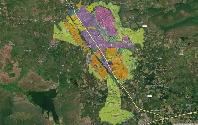
Mandideep Masterplan 2031: Zone Check and Land Use Guide
View Mandideep Masterplan as a live map overlay – check any plot's land use zone for free on 1acre.in. Mandideep Master ...

Pithampur Development Plan 2035: DMIC Zone Check and Land Use Guide
View Pithampur Masterplan as a live map overlay – check any plot's land use zone for free on 1acre.in. Pithampur masterp...
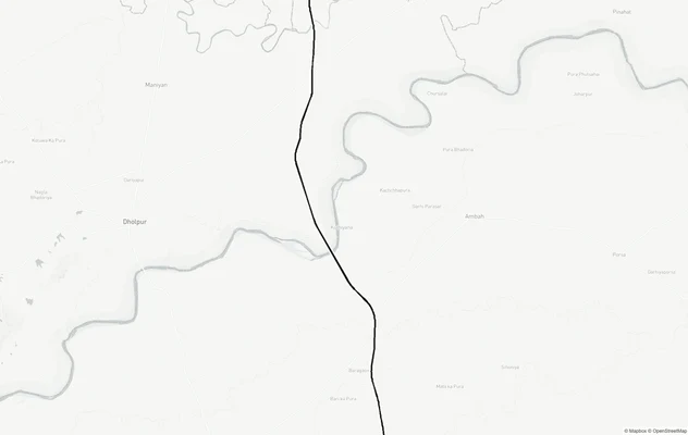
Agra - Gwalior Expressway
View Agra - Gwalior Expressway alignment as a live map overlay – check land acquisition risk and plot proximity free on ...
More Layers in Madhya Pradesh
Mandideep Masterplan 2031: Zone Check and Land Use Guide
View Mandideep Masterplan as a live map overlay – check any plot's land use zone for free on 1acre.in. Mandideep Master ...
Pithampur Development Plan 2035: DMIC Zone Check and Land Use Guide
View Pithampur Masterplan as a live map overlay – check any plot's land use zone for free on 1acre.in. Pithampur masterp...
Agra - Gwalior Expressway
View Agra - Gwalior Expressway alignment as a live map overlay – check land acquisition risk and plot proximity free on ...