Mandideep Masterplan 2031: Zone Check and Land Use Guide
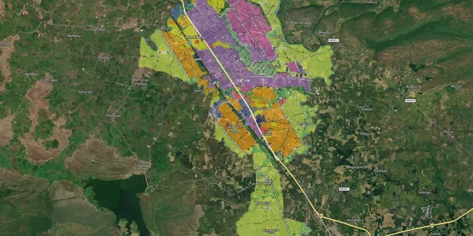
Mandideep Masterplan Preview
Try the Mandideep Masterplan 2031 on the map
Sign in once and explore the layer for a full day.
- No card details needed
- Find nearby verified lands for sale
Overview
Mandideep sits 25 km south of Bhopal in Raisen district, and its Mandideep Master Plan 2031 land zone classification controls exactly what you can build, where you can build it, and what approvals stand between you and construction. The plan is administered by Madhya Pradesh's Directorate of Town and Country Planning under the MP Nagar Tatha Gram Nivesh Adhiniyam, 1973. Mandideep is one of MP's most industrialised towns, home to MPIDC-developed sectors hosting companies like Procter & Gamble, Lupin, and HEG. That industrial backbone drives steady residential and commercial demand, but it also creates specific zone traps that catch buyers who skip the zone verification step. This page covers both.
The Agricultural Land Trap in Mandideep's Peri-Urban Fringe and Why MPIDC Zone Boundaries Matter
Mandideep grew outward from an original 560-acre MPIDC industrial estate to over 2,000 acres. That growth created a wide fringe of land where the map says "agricultural" and the broker says "residential." The two statements can coexist in Madhya Pradesh for years until a buyer discovers the hard way that they need a formal diversion under Section 172 of the Madhya Pradesh Land Revenue Code before a single brick can be laid.
Under MP law, agricultural land cannot be used for residential or commercial purposes without prior permission from the district collector. The premium is calculated on market value, the conversion must begin within three years of purchase, and none of this is automatic just because land sits inside a master plan boundary. Brokers selling plots on the outer edges of Mandideep's residential layout areas frequently skip this detail. If the khasra entry still reads "agricultural," your purchase is legally unbuildable until diversion is complete.
The second trap is specific to Mandideep: the MPIDC industrial zone boundaries. The Mandideep Industrial Area has Sector A and adjacent sectors originally allotted to manufacturing units by MPIDC. Plots abutting these sectors are regularly marketed as "residential" by private sellers, even when the zone designation on the master plan still reads industrial. Changing the use of an industrially designated plot to residential is not a simple diversion; it requires an amendment to the master plan itself, which the DTCP controls, not individual buyers.
The table below shows the core zone types that operate in the Mandideep planning area and the risk each carries for buyers.
Zone
Permitted Use
Conversion Needed?
Common Risk
Residential
Housing, mixed residential
No, if layout approved
Unapproved layouts on khasra-agricultural land
Industrial (MPIDC sectors)
Manufacturing, ancillary units
Not available to private buyers
Sold as "residential adjacent" without zone confirmation
Agricultural
Farming only
Yes, MPLRC Section 172 diversion required
Sold as buildable residential plots without diversion
Commercial
Retail, offices
No, if within designated commercial area
Mixed-use fringe parcels misclassified
The agricultural diversion trap is where money goes missing in Mandideep. Confirm the khasra category at the tehsil office and cross-check it against the master plan zone before any agreement.
Obedullaganj, the Phanda Bypass Corridor, and Where Real Value Is Moving Around Mandideep
Mandideep is not a static market. Two infrastructure decisions have shifted where land value is actually moving, and both involve road projects that are either approved or under construction.
The bigger one is the Mandideep–Phanda western bypass. The Madhya Pradesh cabinet approved a 41 km, four-lane access-controlled corridor starting before Mandideep, running along the Obedullaganj–Mandideep road, and terminating at Phanda Kalan on the Indore highway. Estimated at Rs 30 billion, its stated purpose is direct industrial linkage between Mandideep and Indore without routing traffic through Bhopal. The land acquisition alone required Rs 4.27 billion. Separately, the state also approved a 40.90 km six-lane ring road from Mandideep to Phanda, budgeted at Rs 29.81 billion. Both projects affect about 85 villages, including areas connected to Kolar, Neelbad, Ratibad, and Raisen Road. Plots along these alignments carry acquisition risk; compulsory purchase under land acquisition law delivers circle rate compensation, not market rate.
The second driver is the Bhopal Development Plan 2031, which identifies Mandideep as a "major work center" pulling residential growth southward from Bhopal along Hoshangabad Road. That BDP 2031 designation means Mandideep is within the planning consideration of the Bhopal planning area even though it has its own separate Mandideep Master Plan 2031 administered by DTCP for the Raisen district. Buyers buying near the district boundary need to check which plan their specific plot falls under.
The table below maps the key corridors around Mandideep and what zone status and risk looks like for each.
Corridor / Area
Zone Context
Growth Driver
Known Risk
MPIDC Industrial Sectors (A, B, C)
Industrial zone
Manufacturing employment, established firms
Adjacent plots sold as residential without zone change
Tapti Vihar and VDB Ghar Angan residential colonies
Residential, DTCP layout approved
Workforce housing, NH-46 connectivity
Verify DTCP layout approval number before buying
Obedullaganj–Mandideep road corridor
Agricultural/proposed bypass corridor
Phanda bypass alignment
Acquisition risk: circle rate, not market rate
Raisen Road peripheral fringe
Agricultural, peri-urban
Residential spillover from Bhopal BDP 2031
Agricultural khasra, diversion pending
The corridor that gets misread most often is the Obedullaganj stretch. Buyers see the approved bypass, hear "Mandideep to Indore direct route," and buy agricultural parcels along the alignment expecting appreciation. The appreciation may come, but so might an acquisition notice that pays the circle rate for land that was bought at market rate.
Was this layer helpful?
Anything wrong, outdated, or missing we want to hear it.
For Land Owners & Agents
Looking to sell your land in Madhya Pradesh?
I want to sell my land in Madhya Pradesh
10:32
Plz share your Land's location - We will list it on 1acre map, for Free.
10:32

For Land Buyers
Browse all verified lands & plots in Madhya Pradesh
Every listing goes through our Preliminary Verification Process.
More Layers in Madhya Pradesh
See all 5 layers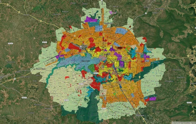
Bhopal Masterplan 2031: BDA Zone Check and Land Use Guide
View Bhopal Masterplan as a live map overlay – check any plot's land use zone for free on 1acre.in. Bhopal masterplan 20...

Pithampur Development Plan 2035: DMIC Zone Check and Land Use Guide
View Pithampur Masterplan as a live map overlay – check any plot's land use zone for free on 1acre.in. Pithampur masterp...
Agra - Gwalior Expressway
View Agra - Gwalior Expressway alignment as a live map overlay – check land acquisition risk and plot proximity free on ...
More Layers in Madhya Pradesh
Bhopal Masterplan 2031: BDA Zone Check and Land Use Guide
View Bhopal Masterplan as a live map overlay – check any plot's land use zone for free on 1acre.in. Bhopal masterplan 20...
Pithampur Development Plan 2035: DMIC Zone Check and Land Use Guide
View Pithampur Masterplan as a live map overlay – check any plot's land use zone for free on 1acre.in. Pithampur masterp...
Agra - Gwalior Expressway
View Agra - Gwalior Expressway alignment as a live map overlay – check land acquisition risk and plot proximity free on ...