Bhubaneshwar Air Funnel Zones
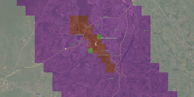
Bhubaneshwar Air Funnel Zones Preview
Try the Bhubaneshwar Air Funnel Zones on the map
Sign in once and explore the layer for a full day.
- No card details needed
- Find nearby verified lands for sale
Overview
The Bhubaneswar airport height restriction zone covers all land within 20 km of the Aerodrome Reference Point (ARP) of Biju Patnaik International Airport. Every structure in this radius requires a No Objection Certificate (NOC) from the Airports Authority of India before construction begins, under GSR 751(E) notified 30 September 2015. AAI published a color-coded zoning map (CCZM) for Bhubaneswar in June 2016, which defines seven permissible top elevation bands ranging from 80 m AMSL to 190 m AMSL. This page explains what those bands mean for your plot, which localities face the tightest caps, and what the Jagamara enforcement case tells buyers right now.
Illegal Construction Near Biju Patnaik Airport: The Regulatory Red Flags No Broker Will Tell You
The CCZM divides Bhubaneswar's airport-adjacent land into elevation bands, and the distinction between them is consequential. Plots inside the tightest zone, where permissible top elevation is 80 m AMSL, leave almost no headroom for multi-story construction once you subtract the site's own ground elevation from that ceiling. The formula is direct: AAI height permitted (AGL) = CCZM permissible top elevation (AMSL) minus site elevation of the plot.
The seven CCZM elevation bands for Bhubaneswar Airport are
Colour Band
Permissible Top Elevation (AMSL)
Implication
Red (innermost)
80 m
NOC from AAI mandatory; near-zero headroom in low-lying areas
Orange
90 m
Strict cap: local body cannot approve above this
Yellow
105 m
Moderate restriction; site elevation determines usable floors
Green
115 m
Most of core city; standard mid-rise possible subject to CCZM check
Blue
135 m
Outer areas: multi-storey feasible pending site elevation
Purple
160 m
Peripheral zone: lower risk but NOC still required within 20 km
Grey (outermost)
190 m
Approaches 20 km radius; height largely unrestricted for typical builds
The critical trap is that heights on the CCZM are in AMSL, not above ground level. A broker quoting floor count without verifying the site's surveyed elevation against the CCZM band is giving you incomplete information. Two adjacent plots in the same locality can sit in different color bands if the topography changes. Verify the grid reference for your exact survey number on the CCZM grid map, also published by AAI for Bhubaneswar.
There is an active enforcement case directly on record for this city. An unauthorized two-story market complex in Jagamara, situated directly under the approach path of flights at Biju Patnaik International Airport, was flagged by airport officials in mid-2025 as a serious obstruction to aircraft operations. The structure was built without the mandatory NOC and, as of the most recent reporting, remained standing because demolition authority rests with the Bhubaneswar Municipal Corporation (BMC) and the Bhubaneswar Development Authority (BDA), not with AAI itself. AAI can flag. It cannot bulldoze. This enforcement gap is the single fact every buyer near the southern approach corridor needs to carry into a site visit.
Pokhariput, Jagamara, and Ghatikia: Which Bhubaneswar Corridors Carry the Most Height Risk
Localities south and southwest of Biju Patnaik International Airport carry the tightest CCZM constraints because they sit directly under the primary runway approach path. The further north and east you go from the ARP, the more headroom the CCZM grants, which is why Patia (approximately 13 km from the airport via Nandankanan Road) sits in a materially more permissive band than Pokhariput (approximately 2 km from the airport via Bhimatangi Road).
The table below maps key localities to their approximate CCZM risk profile based on distance from the ARP and published locality data:
Locality
Approx. Distance from ARP
CCZM Risk Profile
Known Issue
Pokhariput
~2 km
High: innermost bands apply
Very limited construction headroom; NOC always required
Jagamara
~5 km
High: active NOC violation on record
Illegal market complex on flight path as of 2025
Ghatikia
~4 km
High: within inner horizontal surface range
Low permissible AGL for typical ground elevations
Khandagiri
~6 km
Moderate: conical surface zone
Height feasible but CCZM grid check required per plot
Chandrasekharpur
~8 km
Moderate: outer conical zone
Multi-story possible; AAI NOC still mandatory within 20 km
—
—
—
—
Research on Bhubaneswar specifically found that building height thresholds in this city remain low and largely unchanging up to 9 km from the airport before jumping sharply. This is unusual: in several comparable cities, the threshold begins rising earlier. Buyers targeting plots within 9 km of the ARP should treat the CCZM as a hard constraint before any negotiation on price or floor count.
The most misunderstood corridor is the southern stretch through Jagamara toward Sundarpada. Proximity to NH-16 and airport connectivity drive demand there, but that same proximity places plots inside or near the approach funnel, where the permitted building height equals 2% of the distance from the runway edge. At 1,000 m from the runway edge, that cap is 20 m above ground. Buyers looking at this corridor for high-density development face a structural ceiling, and no amount of builder reassurance substitutes for the surveyed site coordinates verified against the CCZM grid.
Was this layer helpful?
Anything wrong, outdated, or missing we want to hear it.
For Land Owners & Agents
Looking to sell your land in Odisha?
I want to sell my land in Bhubaneswar
10:32
Plz share your Land's location - We will list it on 1acre map, for Free.
10:32

For Land Buyers
Browse all verified lands & plots in Odisha
Every listing goes through our Preliminary Verification Process.
More Layers in Odisha
See all 5 layers
Bhubaneshwar Masterplan
View Bhubaneshwar Masterplan as a live map overlay – check any plot's land use zone for free on 1acre.in. Bhubaneswar ma...
Cuttack Masterplan
View Cuttack Masterplan as a live map overlay – check any plot's land use zone for free on 1acre.in. Cuttack CDPA Master...
Odisha CRZ
View Odisha CRZ alignment as a live map overlay – check land acquisition risk and plot proximity free on 1acre.in.
More Layers in Odisha
Bhubaneshwar Masterplan
View Bhubaneshwar Masterplan as a live map overlay – check any plot's land use zone for free on 1acre.in. Bhubaneswar ma...
Cuttack Masterplan
View Cuttack Masterplan as a live map overlay – check any plot's land use zone for free on 1acre.in. Cuttack CDPA Master...
Odisha CRZ
View Odisha CRZ alignment as a live map overlay – check land acquisition risk and plot proximity free on 1acre.in.