Bhubaneshwar Masterplan
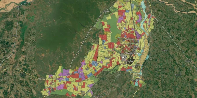
Bhubaneshwar Masterplan Preview
Try the Bhubaneshwar Masterplan on the map
Sign in once and explore the layer for a full day.
- No card details needed
- Find nearby verified lands for sale
Overview
Understanding the Bhubaneswar masterplan zone that covers your plot is the most consequential check in any land transaction in the city. The Bhubaneswar Development Authority (BDA) administers the Comprehensive Development Plan (CDP) 2030, which divides the Bhubaneswar Development Plan Area (BDPA) into 14 planning subzones, each with distinct permitted and prohibited land uses. A separate draft plan for 362 revenue villages in the BDA extended area extends that framework toward 2040. This page covers the two enforcement risks most buyers overlook, the corridors where zone classification directly shapes value, and the exact steps to verify a plot before signing.
ODA court demolitions and the occupancy certificate trap that is catching buyers in Bhubaneswar
The most acute risk in Bhubaneswar's land and property market is not document fraud. It is buying or building in a structure that violates BDA land-use or building standards under the Odisha Development Authority (ODA) Act.
In August 2024, the Odisha government ordered the demolition of at least 191 illegally constructed apartments and buildings in Bhubaneswar. The Housing and Urban Development Minister confirmed 491 total cases in the BDA area alone, with 191 demolition orders formally issued. This followed an earlier ODA court go-ahead for 175 structures. Altogether, over 6,000 cases of building rule violations were pending in the BDA and BMC courts at the time of those orders.
The Supreme Court sharpened this further. On December 17, 2024, in Civil Appeal No. 14604 of 2024, the Supreme Court held that unauthorised constructions are serious threats to planned development and public safety, not merely technical infractions. BDA's own website displays a compliance notice for this judgment. Following that ruling, the Odisha Housing and Urban Development Department issued a directive tying electricity, water, and sewerage connections to valid Occupancy Certificates (OCs). A plot or apartment without an OC now cannot legally receive utility connections.
The table below shows the key documents that must be in order before any Bhubaneswar masterplan zone transaction proceeds.
Document
Issuing Authority
What It Confirms
Risk if Absent
BDA Building/Layout Approval
BDA
Compliance with CDP 2030 land use
Demolition order under the ODA Act
Occupancy Certificate (OC)
BDA / BMC
Construction completed per the approved plan
No utilities; SC order risk
Bhulekh Odisha ROR (Record of Rights)
Revenue Department
Ownership, encumbrance, plot extent
Title chain dispute
Mutation Record
Tahasil Office
Seller's name updated in revenue records
Fraud risk from old ownership claim
RERA Registration Number
ORERA
Project registered under the Real Estate Act 2016
No statutory buyer protection
If a builder or seller cannot produce a BDA layout approval number and a valid OC for the structure, do not proceed. The ODA court system is active, and enforcement is real.
Patia, Chandaka, and Tamando: the three tiers shaping investment decisions near the BDA masterplan growth corridors
The BDPA does not function as a single market. Three distinct tiers have emerged based on proximity to IT employment, road infrastructure, and planned housing density under the CDP 2030.
Patia and the Infocity corridor represent the primary tier. The CDP 2030 identifies Chandrasekharpur, Patia, and adjacent areas as zones earmarked for significant residential and commercial densification. The Infocity and Info Valley IT parks in this zone host over 300 companies employing more than 50,000 professionals, creating sustained rental demand. Apartments in Patia range from approximately ₹5,500 to ₹7,000 per sq. ft., with 6% year-on-year appreciation recorded in 2024-2025.
Chandaka forms the secondary tier. Located in north-western Bhubaneswar, adjacent to the Chandaka Wildlife Sanctuary, this zone recorded 7-9% year-on-year property value appreciation in recent years. The draft BDA 2040 extended area plan includes Chandaka-II zone maps showing a mix of residential, commercial, and agricultural-forest use zones. Buyers here must specifically verify whether their survey number falls within the residential zone boundary or in the forest-adjacent buffer, as these categories carry construction restrictions.
The third tier covers Tamando and Sundarpada on the city's south-western edge. The CDP 2030 designated Tamando as one of the planned new residential growth areas, with the development brief including road connectivity and new social infrastructure. Prices remain lower, but document verification requirements are the same.
Corridor
CDP 2030 Status
Growth Driver
Primary Risk
Patia / Infocity / Chandrasekharpur
Designated residential/commercial
IT parks, 50,000+ jobs
High density, OC compliance essential
Chandaka
Designated residential; 2040 extended area
Proximity to wildlife buffer, NH-16 access
Forest-adjacent buffer zone encroachment
Tamando / Sundarpada
Planned residential expansion
New schools, hospitals, and highway access
Documentation gaps in fringe areas
Pahala-Nakhara belt
NH-16 corridor
Bhubaneswar-Cuttack connectivity
Land disputes in outskirt villages
The most misunderstood corridor is Chandaka. Because the sanctuary boundary is not physically demarcated on the ground, buyers can purchase land that appears to be a clean residential parcel but sits inside or against the forest buffer. The draft BDA 2040 land use map specifically shows agricultural and forest use zones within Chandaka-II that are not available for private residential construction.
Was this layer helpful?
Anything wrong, outdated, or missing we want to hear it.
For Land Owners & Agents
Looking to sell your land in Odisha?
I want to sell my land in Bhubaneswar
10:32
Plz share your Land's location - We will list it on 1acre map, for Free.
10:32

For Land Buyers
Browse all verified lands & plots in Odisha
Every listing goes through our Preliminary Verification Process.
More Layers in Odisha
See all 5 layers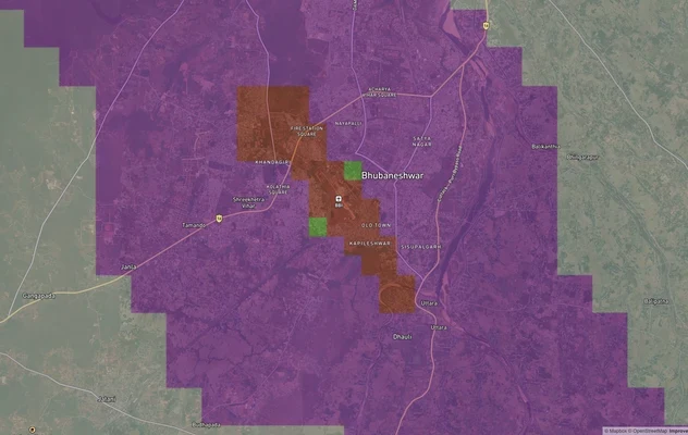
Bhubaneshwar Air Funnel Zones
View Bhubaneshwar Air Funnel Zones on a live map – check height clearance restrictions on any plot for free on 1acre.in....
Cuttack Masterplan
View Cuttack Masterplan as a live map overlay – check any plot's land use zone for free on 1acre.in. Cuttack CDPA Master...
Odisha CRZ
View Odisha CRZ alignment as a live map overlay – check land acquisition risk and plot proximity free on 1acre.in.
More Layers in Odisha
Bhubaneshwar Air Funnel Zones
View Bhubaneshwar Air Funnel Zones on a live map – check height clearance restrictions on any plot for free on 1acre.in....
Cuttack Masterplan
View Cuttack Masterplan as a live map overlay – check any plot's land use zone for free on 1acre.in. Cuttack CDPA Master...
Odisha CRZ
View Odisha CRZ alignment as a live map overlay – check land acquisition risk and plot proximity free on 1acre.in.