Cuttack Masterplan
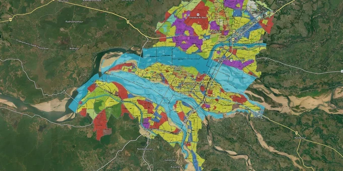
Cuttack Masterplan Preview
Try the Cuttack Masterplan on the map
Sign in once and explore the layer for a full day.
- No card details needed
- Find nearby verified lands for sale
Overview
The Cuttack CDPA Master Plan 2030 is the governing development plan for the Cuttack Development Plan Area, covering 266.37 sq km across 145 revenue villages, the Cuttack Municipal Corporation, and Choudwar Municipality. Prepared by IIT Kharagpur and administered by the Cuttack Development Authority (CDA), it divides the entire area into residential, commercial, industrial, administrative, institutional, open space, transport, riverfront, green belt, and natural drainage channel zones. This premium layer on 1acre maps those zones directly against survey numbers, so you can verify a plot's zone classification before visiting the site. Access requires a Premium subscription.
Why zone mismatches are the biggest risk in Cuttack CDPA land buying
The most dangerous mistake buyers in the CDPA area make is confusing land tenure with zone classification. A plot can have valid revenue records and still sit inside a green belt, a natural drainage channel zone, or a riverfront zone where residential construction is prohibited under the CDPA Master Plan 2030 zoning regulations. Sellers, and sometimes agents, present "stitiban" (freehold) status as proof that a plot is buildable. It is not.
Zone classification and land tenure are two entirely separate questions under Odisha law. The CDA zoning regulations define what activity is permitted in each zone, regardless of whether the land is privately owned.
The table below shows the zone categories defined in the CDPA Master Plan and their buildability status.
Zone Category
Residential Construction Permitted?
Key Restriction
Residential
Yes
Subject to CDA building plan approval
Commercial
Conditional
Requires conversion and CDA sanction
Industrial
No (for housing)
Industrial use only
Green Belt
No
No permanent structures
Natural Drainage Channel
No
Flood-risk buffer, CDA prohibits development
Riverfront
No
Reserved for riverfront development only
Open Space / Institutional
No (private)
Reserved for public amenities
A second trap is the gharabari conversion requirement. Under Section 8-A of the Odisha Land Reforms (OLR) Act, agricultural land cannot be used for residential construction until it is formally converted to gharabari (homestead) classification in the Revenue records. Under the Odisha Land Reforms (Amendment) Act 2023 (w.e.f. 29 December 2023), conversion fees for private agricultural land are 1% of the benchmark market value of the land per acre, regardless of location. Sellers routinely exclude this cost from their quoted price. Before you sign anything, check whether the ROR (Record of Rights) shows kisam as "gharabari" or still shows an agricultural classification such as paddy or orchard land.
Where the CDPA's 11 planning zones actually create buying opportunities
The CDPA Master Plan 2030 divides the planning area into 11 spatial zones, each with a distinct growth trajectory. Not all of them carry the same risk-return profile for a land buyer.
The table below maps key corridors to their zone identity under the CDP and the primary growth driver the plan assigns to each.
Corridor / Locality
CDP Planning Zone
Growth Driver
Key Risk
Bidanasi (Sectors 1–15)
Zone 6, established urban
CDA's Bidanasi township (sector-based planned development), commercial density
Leasehold vs freehold distinction; confirm title type
Choudwar
Zone 4, industrial-residential
Proximity to industrial estates, NH55 access
Industrial zone adjacency; check exact zone boundary
Barang
Zone 10, peri-urban transition
NH16 / Cuttack-Bhubaneswar corridor, Nandankanan connectivity
Green belt pockets along Kuakhai river
Trisulia
Peri-urban (residential transition)
Fast-growing twin-city fringe, high rental demand
"Yellow zone" plots: verify CDA zone map, not just seller claim
Phulnakhara / Bamphakuda
Peripheral residential
NH16 proximity, expansion of Bhubaneswar metro catchment
Outside CMC limits; CDA approval process applies
Trisulia is the most active market right now, and it is also the most misunderstood. The phrase "yellow zone" appears constantly in local listings, but it is a colloquial shorthand derived from the colour coding on the CDA Vision 2030 map, not an official zone classification term in the CDP. A plot described as "yellow zone" may still require a gharabari conversion if the ROR shows agricultural kisam. Cross-reference the 1acre zone map layer against the CDA zonal map at cdacuttack.nic.in before treating any agent's zone claim as final.
Was this layer helpful?
Anything wrong, outdated, or missing we want to hear it.
For Land Owners & Agents
Looking to sell your land in Odisha?
I want to sell my land in Bhubaneswar
10:32
Plz share your Land's location - We will list it on 1acre map, for Free.
10:32

For Land Buyers
Browse all verified lands & plots in Odisha
Every listing goes through our Preliminary Verification Process.
More Layers in Odisha
See all 5 layers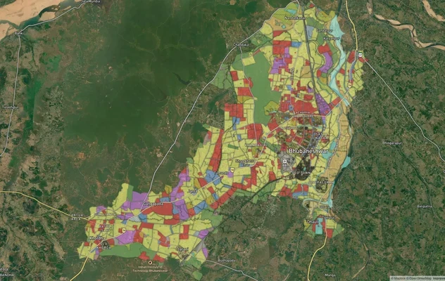
Bhubaneshwar Masterplan
View Bhubaneshwar Masterplan as a live map overlay – check any plot's land use zone for free on 1acre.in. Bhubaneswar ma...
Bhubaneshwar Air Funnel Zones
View Bhubaneshwar Air Funnel Zones on a live map – check height clearance restrictions on any plot for free on 1acre.in....
Odisha CRZ
View Odisha CRZ alignment as a live map overlay – check land acquisition risk and plot proximity free on 1acre.in.
More Layers in Odisha
Bhubaneshwar Masterplan
View Bhubaneshwar Masterplan as a live map overlay – check any plot's land use zone for free on 1acre.in. Bhubaneswar ma...
Bhubaneshwar Air Funnel Zones
View Bhubaneshwar Air Funnel Zones on a live map – check height clearance restrictions on any plot for free on 1acre.in....
Odisha CRZ
View Odisha CRZ alignment as a live map overlay – check land acquisition risk and plot proximity free on 1acre.in.