
Bhu Naksha Andhra Pradesh: Reading the Plot Map
A parcel's paperwork can be flawless while its geography ruins the deal: no road touch, a shape too narrow to build on, a neighbour's encroachment eating a corner. Bhu Naksha puts AP's cadastral geometry on screen so those discoveries happen at your desk, not after the advance.
What Bhu Naksha Andhra Pradesh puts on screen
Definition
Bhu Naksha renders Andhra Pradesh's digitised village maps in a browser: each survey number as a polygon, its neighbours around it, the village fabric of roads and channels between them. It is the pre-visit reconnaissance layer of AP land work, sitting below the FMB in authority.
Use it to interrogate claims. Road frontage, the promise most often inflated, either shows on the village fabric or does not. A plot pitched as corner-facing either has two sides on access or it has one. The screen settles these in seconds.
Study the neighbours as much as the parcel. Polygons that interlock oddly, slivers between surveys, a neighbour's boundary bulging into the subject land, each is a question to carry to the FMB and the site.
Respect the hierarchy. Digitisation introduces drift, so where the screen and the measured FMB sketch disagree, the sketch wins, and where the sketch meets a contested fence line, only a licensed demarcation survey speaks with authority.
Using the Bhu Naksha viewer well
Five focused minutes before any site trip.
Viewer method
When the viewer fails
What to check on the map before a site visit
A desk checklist that saves wasted trips.
| Check | What the screen shows | If it fails |
|---|---|---|
| Road touch | Parcel edge meeting village road fabric | Question the access story |
| Shape usability | Proportions suitable for the intended use | Rethink layouts and setbacks |
| Neighbour fit | Clean interlocking boundaries | Note encroachment risk for the visit |
| Approach route | How you physically reach the parcel | Landlocked parcels need easements |
| Water features | Channels or tanks touching the land | Check classification and flood angle |
| Subdivision lines | Splits visible where claimed | Demand the subdivision FMB |
Common Bhu Naksha issues, and the fix
Map work runs into four recurring frictions.
Why the map screen comes before the site visit
Geography is the earliest cheap filter in AP land buying.
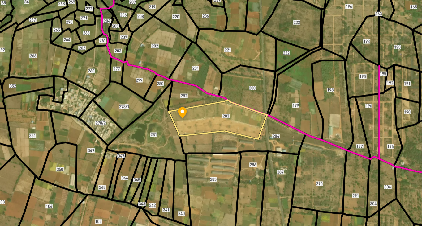
Survey Numbers View on Map Boundaries and numbers come from published state cadastral records. See all map layers.
Looking to sell your land in Andhra Pradesh?

Browse 1,300+ verified lands & plots in Andhra Pradesh
Frequently asked questions
What is Bhu Naksha Andhra Pradesh for?
Is the on-screen boundary authoritative?
My district will not load. Alternatives?
The map and FMB show different shapes?
Can the map prove road access?
Does Bhu Naksha cost anything?
Other Related Guides
Meebhoomi
Every AP land record service in one place, with a guide for each.
Read guide →Pahani ROR 1B Andhra Pradesh: Complete Guide 2026
Check Pahani ROR 1B Andhra Pradesh free on Meebhoomi. Learn what it contains, why it must match the Pattadar Passbook, and how to fix errors before buying land.
Read guide →Adangal Andhra Pradesh Land Records: 2026 Guide
Check Adangal Andhra Pradesh free on Meebhoomi. Learn what wet, dry and waste classification means, how it affects your purchase, and how to spot land use problems.
Read guide →Pattadar Passbook Andhra Pradesh: Complete Guide 2026
What Pattadar Passbook Andhra Pradesh contains, why banks need it for agri loans, how to download it on Meebhoomi, and why transfer after purchase is mandatory.
Read guide →Deed Mother Deed Andhra Pradesh: 2026 Guide
Understand Title Deed and Mother Deed in Andhra Pradesh, how to verify the 30-year chain on IGRS AP, and why a missing link costs you the deal.
Read guide →Mutation Andhra Pradesh Land Records: Complete Guide 2026
How mutation Andhra Pradesh land records works, why buyers must verify within 90 days, how auto mutation updates 1B, and what to do when mutation is pending or rejected.
Read guide →