Port Blair PBPA Masterplan 2030: Zone Check and Land Use Guide
Port Blair Masterplan Preview
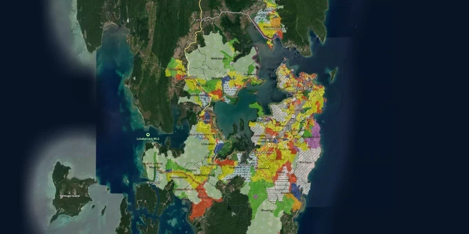
Try the Port Blair PBPA Masterplan 2030 on the map
Sign in once and explore the layer for a full day.
- No card details needed
- Find nearby verified lands for sale
Overview
The Port Blair Planning Area (PBPA) Masterplan 2030 is the operative land use framework for Port Blair town and 34 revenue villages, prepared by the Town and Country Planning Unit of the Andaman Public Works Department (APWD) under the A&N Islands Town and Country Planning Regulations, 1994. The plan came into force on 1st March 2012. It designates zones across primary residential, mixed residential, commercial, industrial, agricultural, defence, submergible land, reserved forest, and special reservation categories. All development within the PBPA requires planning permission from the Port Blair Planning and Development Authority (PBPDA). Note: Port Blair was officially renamed Sri Vijaya Puram on 13 September 2024. This page retains the name "Port Blair" as the statutory planning area name under the 2030 plan.
Agricultural Land Diversion Fraud and Island Coastal Regulation Zone (ICRZ): The Two Traps Swallowing PBPA Buyers
Every active land market in India has its dominant fraud. In the Port Blair Planning Area, it is the sale of undiverted agricultural land for housing. The District Administration has formally warned the public that sub-division of any land holding, and any diversion of land use in PBPA, is strictly governed by the Andaman and Nicobar Island Land Revenue and Land Reforms Regulations, 1966. The sale and purchase of undiverted agricultural land for housing plots is explicitly a fraudulent practice under that advisory, and the administration has stated zero tolerance. Unscrupulous brokers continue to advertise agricultural and hilly revenue area plots for housing ,in print and electronic media ,without disclosing that formal diversion to house site or commercial use has not been completed. Any plot offered without a valid diversion order is an incomplete transaction, regardless of how the title documents look.
The second trap is the Island Coastal Regulation Zone. Port Blair sits on South Andaman Island, and the ICRZ 2019 notification applies to the entire Andaman and Nicobar Islands in place of standard CRZ rules. The PBPA Masterplan 2030 itself shows submergible land zones along coastal and low-lying areas; these are additional restrictions on top of ICRZ controls. Building on ICRZ-1A stretches is prohibited entirely. Revenue officials have demonstrated active enforcement: in October 2024, 4,000 square metres of government land in Austinabad village was reclaimed, five unauthorized structures and fenced encroachments were removed, and illegal construction was halted at four separate sites in Swaraj Dweep in the same operation. These are not isolated cases.
The table below maps the two primary regulatory traps to the verification each demands.
Regulatory Trap
Specific Provision
Document to Demand
Consequence of Skipping
Agricultural land plotted for housing without diversion
ANI Land Revenue & Land Reforms Regulations, 1966
Formal diversion order from Revenue Department
Transaction is fraudulent; structure has no building approval basis
Coastal and submergible land construction
ICRZ Notification 2019 + PBPA submergible land (SL) zone designation
ICRZ clearance; confirm plot is outside Submergible Land (SL) zone on APWD village map
Structure liable to demolition; no resale possible
Check your plot against the APWD village-wise proposed land use maps, available at apwd.and.nic.in, before making any payment. As of August 2024, all land registration processes in the South Andaman District are conducted online, which means title verification is now faster to initiate ,but it does not substitute for the diversion order check.
Dollygunj, Bambooflat, and Sippighat: How PBPA 2030 Zone Maps Separate the Investable from the Risky
The PBPA Masterplan 2030 covers 34 revenue villages, and zone designations vary sharply between them. Dollygunj carries mixed residential and commercial zoning in the APWD village maps, placing it in the highest-demand tier for private buyers. Garacharma appears with a special reservation designation in the Dollygunj village map boundary, which limits private residential development on affected parcels. Calicut Village, per listings that reference the City Town Plan 2030, is being brought under the municipal area boundary, which raises regulatory compliance requirements but also confirms infrastructure intent.
Bambooflat sits across the Chatham waterway, connected by ferry from Haddo Jetty. The Chatham Bridge remained closed to heavy vehicles as of January 2026, with residents staging a formal protest at Bambooflat Jetty over ferry access. Ferry operations from the new Haddo Vehicle Ferry Jetty were promised within 15–20 days of the protest. Gram Panchayat representatives formally appealing to the Chief Secretary for action on ferry and bridge access. Land in Bambooflat is affordable precisely because access is ferry-dependent. A February 2025 proposal before MoRT&H to declare 14 State Highway roads as National Highways includes the Bathu Basthi to Chatham-Bambooflat bridge route and the Wandoor jetty to Sippighat corridor, which would directly improve connectivity for plots in those villages. The proposal is active but has not resulted in a formal notification.
The table below ranks PBPA localities by investment readiness under the 2030 plan zone designations.
Locality
PBPA 2030 Zone Type
Primary Demand Driver
Investment Readiness
Known Risk
Dollygunj
Mixed Residential, Commercial
Near National Highway, expanding commercial activity
High
Premium pricing; limited supply
Prothrapur, Calicut
Residential, expanding municipal boundary
Proximity to Port Blair town, road connectivity
High
Diversion status must be verified on each parcel
Garacharma
Mixed Residential, Special Reservation (portions)
South Andaman census town, established settlement
Medium
Special reservation designation restricts some parcels
Bambooflat
Residential, agriculture (fringes)
Lower price point, NH upgrade proposal Feb 2025
Medium
Ferry access; Chatham Bridge closures documented Oct 2025
Sippighat, Wandoor
Agriculture, forest fringe
NH upgrade proposal covers Wandoor-Sippighat corridor
Low
Agricultural diversion required; Mahatma Gandhi Marine National Park proximity
The most misread locality is Bambooflat. The NH upgrade proposal gives buyers a narrative about future road connectivity, and the price differential versus Dollygunj is real. However, the Chatham Bridge remains structurally problematic, the ferry system is documented as unreliable for ambulances and emergency vehicles, and no formal National Highway notification has been issued as of early 2026. Sippighat and Wandoor plots are routinely advertised near the National Park area without disclosing that agricultural land there still requires a formal diversion under the 1966 Regulations before any house site use is valid. Confirm diversion status for every parcel outside the Port Blair municipal wards before committing funds.
Was this layer helpful?
Anything wrong, outdated, or missing we want to hear it.
For Land Owners & Agents
Looking to sell your land in Andaman And Nicobar Islands?
I want to sell my land in Andaman And Nicobar Islands
10:32
Plz share your Land's location - We will list it on 1acre map, for Free.
10:32

For Land Buyers
Browse all verified lands & plots in Andaman And Nicobar Islands
Every listing goes through our Preliminary Verification Process.
