Srinagar Masterplan
Srinagar Masterplan Preview
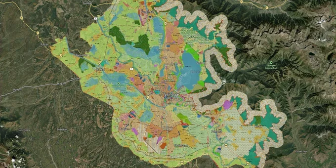
Try the Srinagar Masterplan on the map
Sign in once and explore the layer for a full day.
- No card details needed
- Find nearby verified lands for sale
Overview
Every plot in the Srinagar Metropolitan Region (SMR) gets its development rights from the SMR Master Plan 2035, approved by the State Administrative Council vide Decision No. 40/5/2019 and notified vide Statutory Rules and Orders (SRO) 160 dated 07.03.2019. The Srinagar Development Authority (SDA), constituted under Section 3 of the J&K Development Act 1970, governs all land use, layout approvals, and building permissions across a planning area of 766 sq km, expanded from the earlier 416 sq km. The SMR now spans twelve tehsils across six districts: Srinagar, Budgam, Ganderbal, Pulwama, Bandipora, and Baramula. This page covers the two zone-level restrictions that catch most buyers off guard and the corridors where genuine residential growth is planned.
Dal Lake Buffer Zones and the NH Bypass Construction Ban: Two Hard Stops in the Srinagar Master Plan 2035
Two overlapping prohibitions are built directly into the Srinagar Master Plan 2035, and neither is negotiable. Getting either wrong means buying land you legally cannot build on.
The first is the Dal and Nigeen Lake buffer zone. The J&K and Ladakh High Court in 2002 directed that no new construction be permitted within 200 meters from the center of the foreshore road along Dal Lake. That order remains in force. As recently as December 2024, the High Court directed the government to take a formal policy decision by February 7, 2025, on how to handle even repair and renovation of buildings already within the 200-metre zone that were legitimately constructed before the ban. The J&K Lake Conservation and Management Authority (LCMA) is the body responsible for managing Dal and Nigeen lakes, and buffer zones have been created along the entire lake periphery to prevent encroachment. In June 2025, the government constituted a review committee specifically tasked with examining High Court directions on Dal and Nigeen buffer zones and proposing amendments to the Master Plan 2035 to incorporate those directions. As of March 2026, amendments are awaiting Cabinet approval.
The second prohibition is the NH Bypass corridor. The SAC explicitly carved out a modification when approving the Master Plan: no development or construction activity is permitted along the NH Bypass from Pantha Chowk to Nowgam, which forms part of a flood absorption basin. This was a direct SAC condition vide Decision No. 40/5/2019. Any plot marketed along this stretch for residential or commercial use is being sold in a zone where the highest authority in the state has explicitly blocked construction.
The table below maps the key restriction zones every buyer must identify before making an offer.
Zone / Area
Restriction
Governing Order
Common Risk
Dal and Nigeen Lake buffer (200m)
No new construction; even renovation needs court-sanctioned policy
J&K HC order dated 19.07.2002, ongoing litigation
Waterfront plots marketed as residential without disclosing buffer status
NH Bypass: Pantha Chowk to Nowgam
No development/construction; flood absorption basin
SAC Decision No. 40/5/2019
Plots along the corridor actively marketed as investment land
TPS (Town Planning Scheme) areas
Building permission withheld pending TPS feasibility
Master Plan 2035; June 2025 review committee
Buyers receive no building permit despite owning a zoned residential plot
Wetlands and flood spill channels
Prohibited development under Wetland Rules and Master Plan
NGT, J&K HC ongoing orders
Past haphazard growth in west Srinagar on these exact lands
In August 2025, the J&K and Ladakh High Court ordered demolition of an unauthorized hotel in Srinagar where the built-up area per floor exceeded 19,900 sq ft against a permitted 9,159 sq ft, and directed SDA to submit a compliance report within two months. The court found active SDA official collusion in the violation. A registered sale deed and a building permission do not protect you if the underlying land or the construction violates these restrictions.
Bemina, Nowgam, Zakura and Budgam: Where the Srinagar Master Plan 2035 Directs New Growth
The Master Plan 2035 is frank about where Srinagar must expand. The city cannot absorb more population in its congested historic core. The plan designates three dormitory townships at Nowgam, Lawaypora near HMT, and Bemina, and three satellite townships at Budgam, Pampore, and Ganderbal.
The most concrete near-term project is the proposed 150-hectare Satellite Township along the NH Bypass at Bemina (Rakh Gund Aksha), planned by SDA with residential plots, apartment blocks, offices, commercial centres, and recreational spaces. As of February 2026, this is the plan's primary vehicle for decongesting the core city. The Inner Ring Road (IRR) in the Master Plan runs through Nowgam, Hyderpora, and Tengpora, making the Nowgam belt a natural residential expansion zone, provided flood plain risks are managed. The Zakura corridor was identified by urban planners as the most suitable housing direction for the city, yet remained underutilised in past plan periods.
The satellite districts are a different category of opportunity. Budgam district's rural villages now fall within the 766 sq km SMR boundary, making them subject to Master Plan 2035 development regulations. Ganderbal and Pampore carry satellite township designations in the plan. Before buying in any of these periurban areas, buyers must verify whether the specific parcel falls within a notified Town Planning Scheme area, because TPS preconditions can block building permissions regardless of zone classification.
Corridor / Locality
Growth Role in Master Plan 2035
Key Risk
Bemina, NH Bypass (Rakh Gund Aksha)
150-ha SDA Satellite Township, planned residential
SAC ban applies to specific Pantha Chowk to Nowgam segment; confirm exact plot boundary
Nowgam belt
Dormitory township, Inner Ring Road node
Flood plain risk; Master Plan flagged past haphazard growth in adjacent wetlands
Zakura
Identified housing growth direction by TPO Kashmir
Historically underutilised; confirm zone and TPS status plot by plot
Budgam, Ganderbal, Pampore
Satellite townships under SMR Master Plan 2035
TPS preconditions may block building permissions in these new inclusions
Lawaypora near HMT
Dormitory township designation
Adjacent to flood spill channel corridor; verify land suitability
The TPS precondition issue is the least visible risk in the periurban SMR zones. The June 2025 government committee was constituted precisely to examine which TPS areas should have building permission preconditions removed. Until Cabinet approves Master Plan amendments, buyers in TPS-notified areas cannot obtain building permits even on legitimately zoned residential land.
Was this layer helpful?
Anything wrong, outdated, or missing we want to hear it.
For Land Owners & Agents
Looking to sell your land in Jammu And Kashmir?
I want to sell my land in Jammu And Kashmir
10:32
Plz share your Land's location - We will list it on 1acre map, for Free.
10:32

For Land Buyers
Browse all verified lands & plots in Jammu And Kashmir
Every listing goes through our Preliminary Verification Process.