Goa CRZ
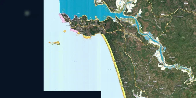
Goa Crz Preview
Try the Goa CRZ on the map
Sign in once and explore the layer for a full day.
- No card details needed
- Find nearby verified lands for sale
Overview
Goa CRZ land is regulated under the CRZ Notification 2019 by the Goa Coastal Zone Management Authority (GCZMA), but Goa remains the only coastal state that has not finalised its Coastal Zone Management Plan (CZMP). As a result, Goa is still governed by CRZ 2011 rules, with the 2019 notification unenforced. The CRZ covers coastal land up to 500 metres from the High Tide Line (HTL) and 100 metres along tidal water bodies.
Goa's Unfinished CZMP and the Khazan Land Risk That Competitors Miss for Coastal Buyers
Goa CRZ land carries a risk no other Indian coastal state shares in the same degree: the state has no finalised, legally notified CZMP under either CRZ 2019 or the updated CRZ 2011 scale. Goa missed the October 2023 and May 2024 CZMP deadlines set by the National Coastal Zone Management Authority. A January 2025 target was set and the draft 2011 CZMP (at 1:4,000 scale) was submitted to the NCZMA (National Coastal Zone Management Authority) in September 2024, but the full 2019 CZMP remains unfinished. Without a notified CZMP, MoEF&CC suspended CRZ clearances in Goa entirely for a period; the risk of another suspension is live.
The second Goa-specific risk is the draft CZMP's documented mapping errors. Architects, planners, and environmental groups identified misclassified khazan lands, incorrectly mapped mangroves, missing jetties and sluice gates, and structures from 1974 to 1991 appearing in zones where they should not. If a property you are considering sits near khazan lands or mangroves, the map classification on a draft CZMP may not reflect the legally correct category.
The table below shows the CRZ categories applicable in Goa, the key areas associated with each, and the construction implications:
CRZ Category
Goa Examples
NDZ from HTL
Construction Status
CRZ-I
Mangroves, khazans, sand dunes, turtle nesting areas
Between LTL and HTL
No new construction; ecologically protected
CRZ-II
Panaji, Vasco, Candolim (developed to shoreline)
Landward side of hazard line
Buildings permitted per FSI/FAR (Floor Space Index/Floor Area Ratio); hazard line boundary must be confirmed
CRZ-IIIA
Dense rural coastal belt (population >2,161/sq km)
50m from HTL (under CRZ 2019)
50m NDZ; limited activities beyond
CRZ-IIIB
Sparse rural coastal villages
200m from HTL
200m NDZ; agriculture and limited public facilities only
CRZ-IV
Water area from LTL seaward
Not applicable
Fishing and allied activities; no solid waste dumping
The key action for any Goa coastal purchase: demand a CRZ Permission certificate specific to your survey number from the GCZMA, a Survey Report from a government-authorised agency showing the actual HTL and LTL (Low Tide Line) lines on the ground, and Approved Building Plans confirming the setback. A sale deed alone cannot override a CRZ restriction; and a structure shown as "cleared" on an error-ridden draft CZMP provides no legal protection.
Panaji to Agonda: Which Goa Coastal Zones Support Legal Development and Where the NDZ Risk Is Highest
CRZ-II areas in Goa's developed municipal belts carry the most straightforward development framework; CRZ-III zones are where NDZ distances determine whether a beachfront plot is buildable or not. A pending NGT challenge to the CRZ 2019 notification adds a further layer of uncertainty specifically for North Goa CRZ-IIIA land.
The table below shows the primary micro-markets across Goa's coastline and the realistic CRZ signal for buyers at each:
Locality / Belt
CRZ Category
Signal
Key Risk
Panaji (Panjim)
CRZ-II (municipal developed)
Buildings permitted on landward side of hazard line
Confirm exact hazard line; no fixed setback from HTL
Vasco da Gama
CRZ-II (developed)
Established urban area; CRZ-II norms apply
Hazard line position must be verified per survey number
Candolim
CRZ-II portions + CRZ-III
Resort and residential belt; CRZ-II sections buildable
NDZ boundary varies; mixed classification common
Mandrem (North Goa)
CRZ-IIIA or IIIB
NDZ reduced to 50m if CRZ-IIIA; significant land value change
CRZ 2019 is being legally challenged; NDZ could revert to 200m
Agonda (South Goa)
CRZ-III (rural)
Beach village; limited development permitted beyond NDZ
Verify population density for IIIA vs IIIB classification
Khazan land belts
CRZ-I
Ecologically sensitive; no new construction
Misclassification risk in draft CZMP documented by professionals
The North Goa CRZ-IIIA belt is the most consequential zone to watch. The reduction of NDZ from 200 metres to 50 metres under CRZ 2019 created significant land value increase in dense coastal villages. But environmental organisations have challenged CRZ 2019 at the NGT, The larger bench heard the challenge on December 10, 2025. As of May 2026, no judgment has been publicly announced — the case remains pending. North Goa CRZ-IIIA land priced on the 50-metre NDZ assumption continues to carry direct exposure to an adverse outcome. If CRZ 2019 is struck down or modified, NDZ distances in CRZ-IIIA areas revert to 200 metres, making plots currently within 50-200 metres of the HTL unbuildable again. Any purchase in the North Goa coastal belt priced on the 50-metre NDZ assumption carries direct exposure to this legal outcome.
Was this layer helpful?
Anything wrong, outdated, or missing we want to hear it.
For Land Owners & Agents
Looking to sell your land in Goa?
I want to sell my land in Goa
10:32
Plz share your Land's location - We will list it on 1acre map, for Free.
10:32

For Land Buyers
Browse all verified lands & plots in Goa
Every listing goes through our Preliminary Verification Process.
More Layers in Goa
See all 3 layers
Goa Survey Number Map — Find Any Plot's Form I & XIV Free | 1acre.in
See any plot's survey number in Goa on a free live map. Form I & XIV, Sanad, PT Sheet and the DSLR portal explained, plu...
Konkan Expressway
View Konkan Expressway alignment as a live map overlay – check land acquisition risk and plot proximity free on 1acre.in...
More Layers in Goa
Goa Survey Number Map — Find Any Plot's Form I & XIV Free | 1acre.in
See any plot's survey number in Goa on a free live map. Form I & XIV, Sanad, PT Sheet and the DSLR portal explained, plu...
Konkan Expressway
View Konkan Expressway alignment as a live map overlay – check land acquisition risk and plot proximity free on 1acre.in...