Konkan Expressway
Konkan Expressway Preview
Try the Konkan Expressway on the map
Sign in once and explore the layer for a full day.
- No card details needed
- Find nearby verified lands for sale
Overview
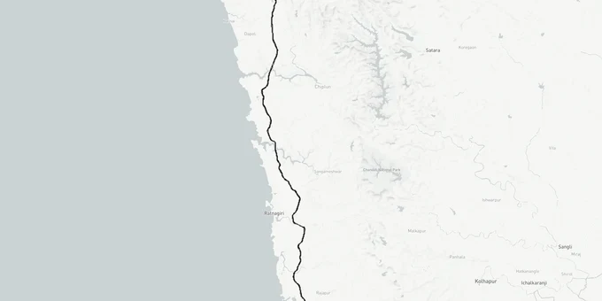
The Konkan Expressway is a proposed 389 km, six-lane greenfield access-controlled highway (revised DPR, December 2024; earlier alignment was cited as 389 km (revised DPR Dec 2024)) being developed by MSRDC, running from Chirle Village, Panvel, to Patradevi on the Maharashtra-Goa border, passing through Raigad, Ratnagiri, and Sindhudurg. MSRDC completed a revised Detailed Project Report (DPR) in December 2024 and applied for environmental clearance. The Environment Assessment Authorities have since raised Additional Details Sought (ADS), requiring MSRDC to submit further information before clearance can proceed. The revised DPR indicates approximately 4,205 hectares of land required, including around 146 hectares of forest land; earlier figures cited 4,205 hectares (revised DPR; earlier figure was 3,792 ha). Verify the current approved figure with MSRDC. This layer shows the expressway's alignment corridor as per the submitted DPR.
Eco-Sensitive Zone (ESZ) Conflicts and Non-Agricultural (NA) Status: The Two Traps That Catch Most Konkan Expressway Land Buyers
The Konkan Expressway land buying rush has arrived ahead of the project. That timing creates two specific risks that no amount of broker enthusiasm cancels out. First: the expressway's Section 3, land acquisition, was submitted to the Maharashtra government but was sent back for reworking because the alignment is subject to change due to Eco-Sensitive Zone (ESZ) conflicts. A plot that sits on the current DPR alignment line may not sit on the final built alignment. Buying adjacent to the route before ESZ-driven realignments are resolved is a bet, not an investment.
Second: most land along this corridor is agricultural by default. Under Maharashtra law, non-farmers cannot directly purchase agricultural land. Plots offered as "proposed NA" (non-agricultural) carry genuine legal risk: without a confirmed NA order from the local revenue office, no residential or commercial construction is legally permissible, regardless of what the broker shows you.
The table below shows what each land classification means for a buyer looking at Konkan Expressway corridor plots.
Land Type
Who Can Buy
Build Permission
Key Verification Document
Risk Level
Agricultural (7/12 recorded)
Farmers only
No (NA conversion required)
7/12 extract, revenue records
High for non-farmers
NA Plot (order received)
Any buyer
Yes, subject to Coastal Regulation Zone (CRZ) and ESZ rules
NA order from Taluka office
Low to medium
Proposed NA (conversion pending)
Any buyer
Not yet
Application number only
High
Forest / ESZ-designated land
Restricted
Prohibited for commercial use
Ministry of Environment, Forest and Climate Change (MoEFCC) notification
Very high
Check the 7/12 extract and the NA order from the local revenue office before any purchase. A verbal assurance from a developer that NA conversion is "in process" is not a valid substitute for a stamped government order.
Vengurla, Sawantwadi, Patradevi: Where the Konkan Expressway Corridor Creates Real Land Value
The expressway's final section runs through Sindhudurg, terminating at Patradevi on the Goa border, and this is where the most actionable investment thesis sits. Vengurla and Sawantwadi are the two micro-markets with convergent demand: MOPA International Airport (North Goa) is within 42 km of Vengurla; Chipi Airport (Sindhudurg) is within 31 km; and the Goa border-side commerce node at Patradevi-area land directly benefits from both the expressway and the Nagpur-Goa Shaktipeeth Expressway, which received Maharashtra Cabinet approval and has begun land acquisition at approximately ₹20,787 crore.
The table below maps the key corridors along the Sindhudurg section of the Konkan Expressway, their distance to anchor infrastructure, and the known buyer demand profile.
Corridor
Expressway Proximity
Nearest Airport
Plot Price Range (approx.)
Primary Demand Type
Vengurla
Within final expressway section
Chipi: 31 km, MOPA: 42 km
₹21.5 lakh – ₹4 crore (indicative; verify current rates)
Second homes, beach tourism
Sawantwadi
Goa border corridor
MOPA: approx. 50 km
From ₹4.86 crore (indicative; verify current rates) (large parcels)
Tourism, residential
Patradevi belt
Expressway terminus zone
MOPA: under 60 km
—
Border commerce, logistics
Devgad
Mid-Sindhudurg alignment
Chipi: 50 km
Entry from ₹40 lakh (indicative; verify current rates)
Agricultural/second home
Vengurla is the most misunderstood corridor in this belt. Plots here range from ₹21.5 lakh to ₹4 crore depending on NA status, beach proximity, and road access. The spread is that wide because NA-converted plots with clear road access and government-confirmed titles command a 3-5x premium over agricultural plots without NA orders in the same taluka. The expressway multiplies value for plots already legally ready to build; it does not fix title or conversion problems.
Was this layer helpful?
Anything wrong, outdated, or missing we want to hear it.
For Land Owners & Agents
Looking to sell your land in Goa?
I want to sell my land in Goa
10:32
Plz share your Land's location - We will list it on 1acre map, for Free.
10:32

For Land Buyers
Browse all verified lands & plots in Goa
Every listing goes through our Preliminary Verification Process.
More Layers in Goa
See all 3 layers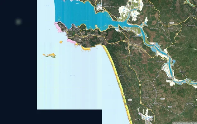
Goa CRZ
View Goa CRZ alignment as a live map overlay – check land acquisition risk and plot proximity free on 1acre.in.

Goa Survey Number Map — Find Any Plot's Form I & XIV Free | 1acre.in
See any plot's survey number in Goa on a free live map. Form I & XIV, Sanad, PT Sheet and the DSLR portal explained, plu...
More Layers in Goa
Goa CRZ
View Goa CRZ alignment as a live map overlay – check land acquisition risk and plot proximity free on 1acre.in.
Goa Survey Number Map — Find Any Plot's Form I & XIV Free | 1acre.in
See any plot's survey number in Goa on a free live map. Form I & XIV, Sanad, PT Sheet and the DSLR portal explained, plu...