VGTM Masterplan: Vijayawada-Guntur Zone Check and Land Use Guide
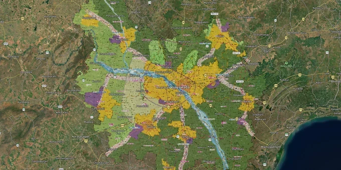
Vgtm Masterplan Preview
Try the VGTM Masterplan on the map
Sign in once and explore the layer for a full day.
- No card details needed
- Find nearby verified lands for sale
Overview
The VGTM masterplan zone is now administered under the APCRDA Region Masterplan 2050, originally covering 57 mandals across Guntur and Krishna districts (with jurisdiction subsequently expanded to 6 districts: Guntur, Eluru, NTR, Krishna, Palnadu, and Bapatla), with a total jurisdictional area of 8,352.69 sq km. APCRDA , the Andhra Pradesh Capital Region Development Authority , was established under the APCRDA Act 2014, replacing the older VGTM Urban Development Authority that had governed this corridor since 1978. The Masterplan 2050 divides the region into six zone families: Agricultural Protection, Urban (existing and proposed), Industrial, Development Corridor, Infrastructure, and Protection. This page covers what each zone permits, where the legal traps are, and which micro-markets have real investable value in 2025.
Why agricultural protection zones and assigned land are still the biggest risks in the APCRDA region
Here is something brokers in this corridor rarely say upfront: the broader APCRDA Region Master Plan has not yet received formal state government approval as of mid-2025. What exists is a draft perspective. Plan prepared by Singapore-based consultancy Surbana Jurong, plus the 2004 Zonal Development Plans from the erstwhile VGTM UDA, which APCRDA itself acknowledges no longer reflect ground realities. Planning is currently guided by government orders, land use designations, and building bye-laws rather than a single notified document. That creates a specific kind of risk: the zone classification on a broker's printout may be aspirational, not legally operative.
The harder risk runs deeper. The AP CID's 2024 chargesheet documented 945.82 acres of assigned land across the villages of Mandadam, Velagapudi, Rayapudi, and Uddandarayunipalem that were included in the Land Pooling Scheme through G.O. MS No. 41, overriding the Advocate General's explicit opinion that assigned land cannot be transferred. Assigned lands under the Andhra Pradesh Assigned Lands (Prohibition of Transfer) Act are non-transferable by definition. If the Land Pooling Scheme (LPS) plot receipt in front of you traces back to a survey number that was assigned land in the 2014 revenue records, that receipt cannot give you clear title.
The table below maps the six zone families from the APCRDA Masterplan 2050 and what each means for a buyer.
Zone
Permitted Activity
Development Without APCRDA Permission?
Primary Risk
Agricultural Protection Zone (APZ-1/2/3)
Agriculture only; limited rural residential near existing habitations
Not permitted
Sold as future urban or LPS land
Existing Urban Zone
Residential, commercial, institutional per building rules
Within notified limits only
Boundary overlap with adjoining APZ
Proposed Urbanized Zone
Residential and commercial after APCRDA sanction
Permission required first
Sold as approved before sanction is issued
Industrial Zone
Industry, logistics, warehousing
APCRDA approval required
Assigned land intermixed in some pockets
Development Corridor
Mixed use along major roads: NH-16 and NH-65 priority roads
Controlled; permission-based
Road widening notifications affect setback calculations
Protection Zone (water bodies, hills, forests)
No permanent construction
Prohibited entirely
Krishna River delta and lake buffer encroachments near Vijayawada periurban
One more thing worth knowing. The AP Capital Region Land Pooling Scheme Rules 2025, notified under G.O.MS.No. 118, make the APCRDA Commissioner the sole competent authority for all land pooling within the capital region. Any objection to a pooling order must be filed within 15 days of communication. That window is short. If you are buying within or adjacent to an LPS area, check whether any such notification has been issued for that village before you commit.
Where the APCRDA masterplan creates genuine value: Thullur, the Mangalagiri-Tadepalli belt, and the NH-16 corridor
Two things are happening at once in this corridor. Land prices in the Seed Capital Area have appreciated 10 to 15 times since the original 2015-16 Land Pooling Scheme, with CRDA plots in Thullur and Velagapudi trading at Rs 40,000 to Rs 60,000 per sq yard on main roads as of early 2025. Meanwhile, a large share of the surrounding villages still carry agricultural protection zone classification in the draft plan, and those villages are being actively marketed as investment land.
Thullur and Velagapudi sit at the center of the Amaravati Seed Capital Area, which covers 16.94 sq km and houses the temporary Secretariat and High Court buildings at Velagapudi (permanent High Court complex under construction since Dec 2025, completion targeted 2027), and the concentration of CRDA infrastructure investment. The CRDA has sub-registrar offices at Thullur, Ananthavaram, and Mandadam, which tells you where registered transactions are actually happening. These are the villages with the clearest title environment in the APCRDA region. Prices reflect that.
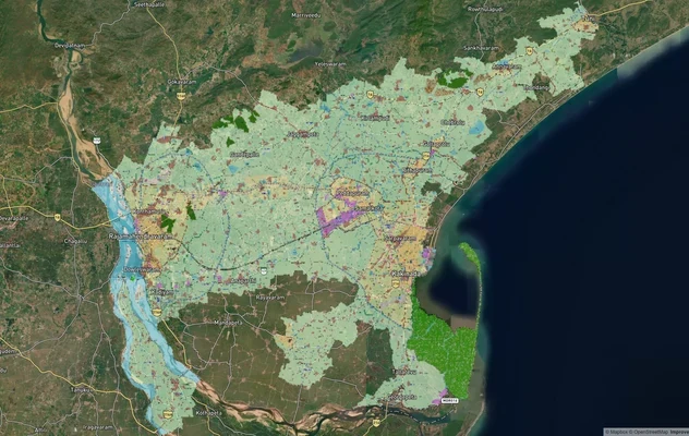
The Tadepalli-Mangalagiri-Undavalli belt occupies the existing urban zone between Vijayawada and the Amaravati capital city boundary. It sits within the Mangalagiri-Tadepalli Municipal Corporation, which creates a separate administrative jurisdiction from the APCRDA Capital City area proper. Buyers priced out of Thullur have been entering here, with land at Rs 40,000 to Rs 60,000 per sq yard in early 2025. The regulatory split between Mangalagiri-Tadepalli Municipal Corporation (MTMC) limits and APCRDA Capital City area matters: confirm which set of building regulations applies to your specific survey number before you commission any architectural plans.
The table below summarizes the key micro-markets by zone status and current price signal.
Micro-market
Zone
Price signal (early 2025)
Growth driver
Primary risk
Thullur / Velagapudi
Existing Urban / Seed Capital Area
Rs 40,000–60,000/sq yd
Secretariat, High Court, CRDA concentration
Assigned land parcels in surrounding survey numbers
Tadepalli / Mangalagiri / Undavalli
Existing Urban Zone
Rs 40,000–60,000/sq yd
Vijayawada-Amaravati corridor demand
Regulatory split between MTMC and APCRDA Capital City
Mandadam / Rayapudi
Proposed Urban / LPS villages
Rs 20,000–25,000/sq yd
Second-phase LPS capital development
Assigned land cited in CID chargesheet for this village
NH-16 / NH-65 belt, Guntur-Vijayawada
Development Corridor / Proposed Urbanized
Agricultural Rs 1–3 Cr/acre
Regional connectivity; planned industrial hubs at Gannavaram and Sattenapalli
APZ parcels being sold without APCRDA sanction
Mandadam deserves a specific warning. It is an LPS village with genuine long-term upside, sits adjacent to the Government Complex, and is legitimately a second-phase development area. Its name is also the one that appears in the CID chargesheet. A legitimate LPS plot and a fraudulently registered assigned land plot can sit on the same street in that village. The way to separate them is to check the survey number against 2014 revenue records, specifically the Adangal, not just the LPS receipt the seller hands you.
Was this layer helpful?
Anything wrong, outdated, or missing we want to hear it.
For Land Owners & Agents
Looking to sell your land in Andhra Pradesh?
I want to sell my land in Amaravati
10:32
Plz share your Land's location - We will list it on 1acre map, for Free.
10:32

For Land Buyers
Browse all verified lands & plots in Andhra Pradesh
Every listing goes through our Preliminary Verification Process.
More Layers in Andhra Pradesh
See all 17 layers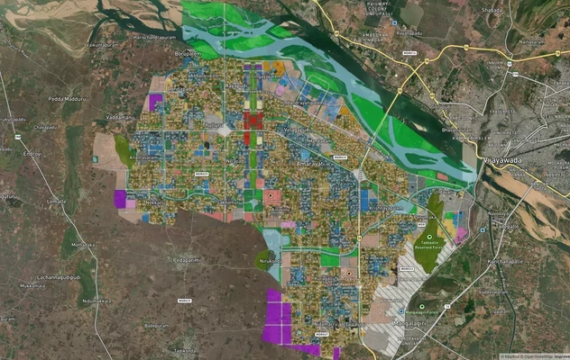
Amaravati APCRDA Masterplan 2050: Zone Check and Land Use Guide
View Amaravati Masterplan as a live map overlay – check any plot's land use zone for free on 1acre.in. APCRDA masterplan...
Kakinada Masterplan: Zone Check and Land Use Guide
View Kakinada Masterplan as a live map overlay – check any plot's land use zone for free on 1acre.in. Kakinada masterpla...
Tirupati TUDA Masterplan: Zone Check and Land Use Guide
View Tirupati Masterplan as a live map overlay – check any plot's land use zone for free on 1acre.in. Tirupati TUDA mast...
More Layers in Andhra Pradesh
Amaravati APCRDA Masterplan 2050: Zone Check and Land Use Guide
View Amaravati Masterplan as a live map overlay – check any plot's land use zone for free on 1acre.in. APCRDA masterplan...
Kakinada Masterplan: Zone Check and Land Use Guide
View Kakinada Masterplan as a live map overlay – check any plot's land use zone for free on 1acre.in. Kakinada masterpla...
Tirupati TUDA Masterplan: Zone Check and Land Use Guide
View Tirupati Masterplan as a live map overlay – check any plot's land use zone for free on 1acre.in. Tirupati TUDA mast...