Tirupati Air Funnel Zones: Building Height Restrictions
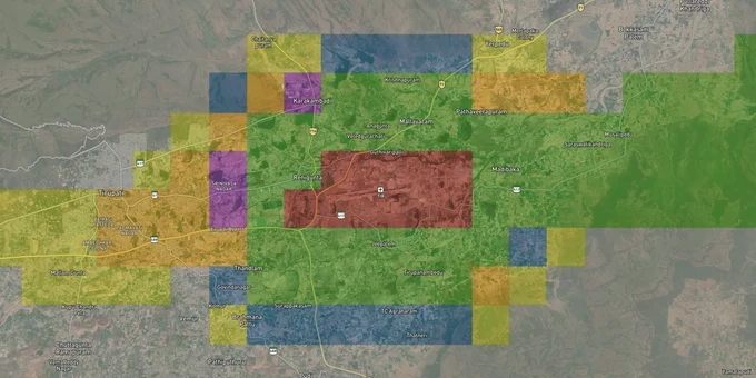
Tirupati Air Funnel Zones Preview
Try the Tirupati Air Funnel Zones on the map
Sign in once and explore the layer for a full day.
- No card details needed
- Find nearby verified lands for sale
Overview
Tirupati Airport (IATA: TIR, ICAO: VOTP), located at Renigunta on NH-71, about 14 km from Tirupati city, is an international instrument-runway airport. Under G.S.R. 751(E), the Ministry of Civil Aviation's Height Restrictions for Safeguarding of Aircraft Operations Rules 2015, every structure within 20 km of the Aerodrome Reference Point (ARP) requires a No Objection Certificate (NOC) for height clearance from the Airports Authority of India (AAI). This 1-acre layer maps the AAI Color-Coded Zoning Map (CCZM) data for Tirupati, showing where funnel zones, approach surfaces, and height caps directly constrain what you can build.
Growth Corridors Near Tirupati Airport: Which Zones Reward Buyers and Which Trap Them
The airport-adjacent belt running from Renigunta through Korramenigunta toward Anjimedu holds the strongest short-term growth signal in Tirupati, driven by the Electronics Manufacturing Cluster, the IIT and IISER campuses at Yerpedu, and the expanded runway now handling wide-body aircraft. But this exact belt sits closest to the funnel zone, and speculative plots here are being marketed without disclosing the height ceiling.
The table below maps the key corridors by their approximate OLS position and real development risk:
Corridor / Locality
Approx. Distance from ARP
OLS Zone Likely
Growth Driver
Key Risk
Renigunta town / Anjimedu
1–3 km
Approach funnel, Inner Horizontal
Airport proximity premium
Severe height cap: possibly G+1 only
Korramenigunta
2–4 km
Inner Horizontal Surface
Electronics Cluster proximity
45 m cap triggers AAI review
Govindavaram / D-Mallavaram
4–6 km
Conical/Transitional
Airport road corridor
Height increases but NOC still mandatory
Yerpedu / IIT-IISER belt
6–10 km
Outer Horizontal
Education, tech employment
NOC needed, manageable height
Chandragiri / Mangalam
12–15 km
Peripheral zone
City connectivity, highway access
NOC required, no height cap
The most misunderstood corridor is the Anjimedu-Renigunta stretch. Builders are marketing plots here as "5 minutes from airport" investment opportunities. What they omit: plots in the approach funnel may legally support only low-rise construction. Banks have begun refusing loans on projects without AAI height clearance, so buyers who purchase without an NOCAS check can find themselves holding land that cannot be financed for development. Before you sign a sale agreement for any plot within 10 km of Renigunta, request the seller's NOCAS application reference or commission your own licensed surveyor's site elevation certificate.
Was this layer helpful?
Anything wrong, outdated, or missing we want to hear it.
For Land Owners & Agents
Looking to sell your land in Andhra Pradesh?
I want to sell my land in Amaravati
10:32
Plz share your Land's location - We will list it on 1acre map, for Free.
10:32

For Land Buyers
Browse all verified lands & plots in Andhra Pradesh
Every listing goes through our Preliminary Verification Process.
More Layers in Andhra Pradesh
See all 17 layers
Tirupati TUDA Masterplan: Zone Check and Land Use Guide
View Tirupati Masterplan as a live map overlay – check any plot's land use zone for free on 1acre.in. Tirupati TUDA mast...
Amaravati APCRDA Masterplan 2050: Zone Check and Land Use Guide
View Amaravati Masterplan as a live map overlay – check any plot's land use zone for free on 1acre.in. APCRDA masterplan...
Kakinada Masterplan: Zone Check and Land Use Guide
View Kakinada Masterplan as a live map overlay – check any plot's land use zone for free on 1acre.in. Kakinada masterpla...
More Layers in Andhra Pradesh
Tirupati TUDA Masterplan: Zone Check and Land Use Guide
View Tirupati Masterplan as a live map overlay – check any plot's land use zone for free on 1acre.in. Tirupati TUDA mast...
Amaravati APCRDA Masterplan 2050: Zone Check and Land Use Guide
View Amaravati Masterplan as a live map overlay – check any plot's land use zone for free on 1acre.in. APCRDA masterplan...
Kakinada Masterplan: Zone Check and Land Use Guide
View Kakinada Masterplan as a live map overlay – check any plot's land use zone for free on 1acre.in. Kakinada masterpla...