Tirupati TUDA Masterplan: Zone Check and Land Use Guide
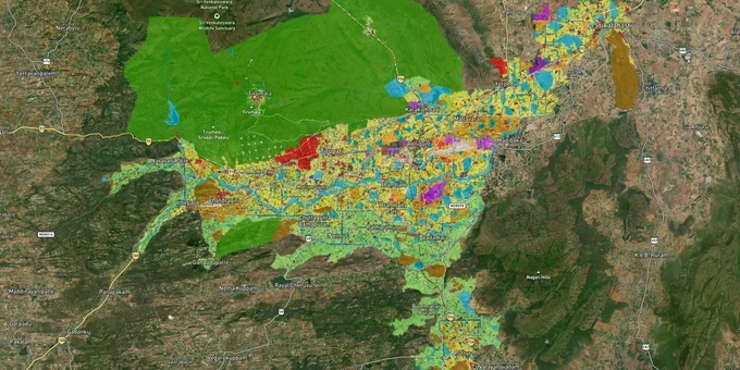
Tirupati Masterplan Preview
Try the Tirupati TUDA Masterplan on the map
Sign in once and explore the layer for a full day.
- No card details needed
- Find nearby verified lands for sale
Overview
The Tirupati TUDA masterplan zone framework covers approximately 8,319.65 sq km under the Tirupati Urban Development Authority, implemented in 2019 and operative until 2040. The TUDA Zoning and Development Promotion Regulations divide the area into zones including R1 Residential Growth Center, R2 Settlement, Commercial, Industrial, Agricultural, Water Bodies, Open Spaces, and Conservation and apply across eight urban mandals: Tirupati, Srikalahasti, Puttur, Nagari, Venkatagiri, Naidupeta, Sullurpeta, and Cuddur. This page covers the zone rules that govern what you can build, where layouts need TUDA approval, and which traps have already cost buyers across the TUDA region.
Renigunta Road, Yerpedu, Srikalahasti, and Tiruchanur: which corridor matches your risk appetite
TUDA's approximately 8,319.65 sq km jurisdiction spans very different zone characters, from the dense urban core around Tirupati Railway Station to industrial corridors near Renigunta Airport and agricultural stretches toward Srikalahasti and Puttur. The corridor you buy in determines both your zone classification and your realistic development timeline.
The Renigunta Road and Yerpedu belt is the most active investment corridor. Renigunta hosts Tirupati International Airport, IT hubs, and EMC zones; Yerpedu is being developed as a high-tech city corridor with proximity to IIT and IISER Tirupati campuses. TUDA-approved layouts along this corridor are actively selling, with LP numbers such as TUDA/DPMS/3/2025/1166 confirming recently sanctioned projects. Srikalahasti, 30 km east, benefits from industrial growth and the Tirupati–Srikalahasti six-lane road upgrade, making it an industrial and residential expansion node. Tiruchanur, home to Padmavathi Temple, carries the highest rental yields in the TUDA zone, driven by year-round pilgrimage traffic.
The table below maps the key corridors within the TUDA masterplan zone to their zone character and known risk.
Corridor / Locality
Zone Character (TUDA Masterplan 2040)
Primary Growth Driver
Key Risk
Renigunta Road / Airport belt
R1 Residential Growth Center + Commercial nodes
Tirupati International Airport, IT and EMC hubs, NH connectivity
Plots marketed as TUDA approved without valid LP number; agricultural fringe land sold before conversion
Yerpedu
R1 Residential Growth Center
IIT Tirupati, IISER Tirupati, high-tech city corridor designation
Fast-growing area with unapproved layouts alongside legitimate TUDA-sanctioned ones; verify LP number before purchase
Tiruchanur
R1 Residential + Special Development (Tourism) node
Padmavathi Temple pilgrimage demand; year-round rental income
Construction within buffer zones around the Tiruchanur node subject to Special Development restrictions; confirm permissible use against zone map
Srikalahasti
R1 Residential + Industrial
Six-lane road to Tirupati; industrial growth; Kapilatirtham Temple tourism
Industrial zone land adjacent to residential areas often sold as purely residential; zone check is essential
Chandragiri
R2 Settlement + Agricultural fringe
Chandragiri Fort heritage corridor; NH connectivity
Heritage and Conservation zone designations restrict construction; confirm zone before purchase
Mangalam Road / Akkarampalle
R1 Residential (urban fringe)
Proximity to Tirupati city centre; affordable entry price
Documented concentration of non-approved plots: Akkarampalle features prominently in unapproved listing databases
The most misunderstood area is Tiruchanur. The TUDA Zoning and Use Regulations designate it as a commercial node with special development permissions and state that residential use may be permitted only to the extent of 20% of the principal activity. This means the zone is not a straightforward residential zone. Buyers purchasing plots near the Padmavathi Temple complex assuming standard residential construction rights need to verify the specific permissible use for their survey number against the Tiruchanur Node zone table, not just the broader TUDA masterplan zone classification.
Was this layer helpful?
Anything wrong, outdated, or missing we want to hear it.
For Land Owners & Agents
Looking to sell your land in Andhra Pradesh?
I want to sell my land in Amaravati
10:32
Plz share your Land's location - We will list it on 1acre map, for Free.
10:32

For Land Buyers
Browse all verified lands & plots in Andhra Pradesh
Every listing goes through our Preliminary Verification Process.
More Layers in Andhra Pradesh
See all 17 layers
Tirupati Air Funnel Zones: Building Height Restrictions
View Tirupati Air Funnel Zones on a live map – check height clearance restrictions on any plot for free on 1acre.in. Tir...
Amaravati APCRDA Masterplan 2050: Zone Check and Land Use Guide
View Amaravati Masterplan as a live map overlay – check any plot's land use zone for free on 1acre.in. APCRDA masterplan...
Kakinada Masterplan: Zone Check and Land Use Guide
View Kakinada Masterplan as a live map overlay – check any plot's land use zone for free on 1acre.in. Kakinada masterpla...
More Layers in Andhra Pradesh
Tirupati Air Funnel Zones: Building Height Restrictions
View Tirupati Air Funnel Zones on a live map – check height clearance restrictions on any plot for free on 1acre.in. Tir...
Amaravati APCRDA Masterplan 2050: Zone Check and Land Use Guide
View Amaravati Masterplan as a live map overlay – check any plot's land use zone for free on 1acre.in. APCRDA masterplan...
Kakinada Masterplan: Zone Check and Land Use Guide
View Kakinada Masterplan as a live map overlay – check any plot's land use zone for free on 1acre.in. Kakinada masterpla...