Amaravati APCRDA Masterplan 2050: Zone Check and Land Use Guide
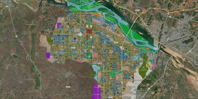
Amaravati Masterplan Preview
Try the Amaravati APCRDA Masterplan 2050 on the map
Sign in once and explore the layer for a full day.
- No card details needed
- Find nearby verified lands for sale
Overview
The APCRDA Masterplan 2050 zone framework governs all land use and development across the 217.23 sq km Amaravati Capital City, prepared by the Andhra Pradesh Capital Region Development Authority (APCRDA) and implemented from 2016 with a planning horizon to 2050. The plan designates zone codes across Residential, Commercial, Industrial, Institutional, and Special Area categories, with the 16.94 sq km Seed Capital Area forming the administrative and commercial core. This page covers the specific regulatory risks unique to Amaravati's land pooling structure, the corridors where zone classification drives real investment demand, and how to use 1acre's tools to verify a plot remotely.
LPS Plot Titles, Non-CRDA Zone Land, and the Two Document Risks That Stop Amaravati Deals
Amaravati is unlike any other Indian city for one specific reason: a large portion of transactable land within the capital region was originally pooled from farmers under the Land Pooling Scheme (LPS) and reconstituted as residential and commercial return plots. This creates a document verification challenge that does not exist in standard real estate markets. Buyers must confirm that a plot being offered for sale carries a valid Land Pooling Ownership Certificate (LPOC), which is the instrument that formally records the farmer's reconstituted plot ownership within the APCRDA masterplan 2050 zone. Plots sold without an LPOC, or with only a verbal claim of LPS origin, carry a title defect that will surface at registration.
The second risk is non-CRDA zone agricultural land marketed as capital-adjacent investment. The APCRDA jurisdictional area covers 8,352.69 sq km, but the Amaravati Capital City, with full masterplan zoning, covers only 217.23 sq km. Land outside this boundary, even if located a short distance from the Seed Capital Area or the proposed High Court complex, does not carry APCRDA zone classification or the development rights that come with it. Brokers routinely market agricultural parcels in Tadikonda, Pedamadduru, and outer Guntur villages as "capital region land" without disclosing that the plots fall outside the masterplan boundary.
The table below sets out the zone categories under the APCRDA Zoning Regulations 2016, and the key buyer risk each carries.
Zone Code
Zone Name
Key Buyer Risk
R1 to R4
Residential
Confirm LPOC or APCRDA layout approval; verify zone sub-category before planning density
C1 to C6
Commercial / CBD
Seed Capital Area commercial plots have specific height and setback rules; verify zone sub-code
I1 to I3
Industrial / Business Park
Non-polluting industries only; standalone residential not permitted
P / S
Institutional / Public
Government, education, health facilities, and private residential are not permitted without a specific order
Green / Open
Parks and Ecological Reserve
30% of the total city area; construction not permitted; commonly mislabelled as R-zone in outer villages
If a seller cannot produce either an LPOC or a current APCRDA layout approval certificate matched to the survey number, the title status is unverified.
Thullur to Mangalagiri: Where the APCRDA Masterplan 2050 Zone Shapes Real Investment Decisions
The APCRDA masterplan 2050 organises Amaravati around nine thematic cities within the broader capital footprint: Justice City, Knowledge City, Health City, Financial City, Sports City, Tourism City, Government Complex, and the Central Business District. Zone classification within and between these nodes determines whether a plot supports residential construction, commercial development, or institutional use. Corridors that sit within the designated 217.23 sq km capital boundary carry APCRDA zone classification; those outside do not, regardless of proximity.
The new LPS Rules 2025 introduced a Phase 2 expansion that targets an additional 40,000 acres beyond the original 54,000 acres, incorporating Mangalagiri, Tadepalli, Guntur, and Vijayawada into the capital mega-city footprint. This expansion is under active implementation as of mid-2025, meaning some corridors currently without full APCRDA zone coverage may acquire it as the Phase 2 boundary is notified. Buyers in these transition-zone corridors carry more uncertainty than those within the established Phase 1 boundary.
The table below shows corridors within the current APCRDA masterplan boundary and their zone profile.
Corridor
Zone Profile
Growth Driver
Key Risk
Thullur
Residential / Government Complex
Proximity to Secretariat, High Court, Seed Capital Area
Confirm LPOC; active non-LPS plots (outside the pooling scheme, title unverified) circulating in market
Velagapudi
Residential / Institutional
Seat of government, VIT-AP University nearby
Highest demand, highest risk of title confusion on small plots
Nidamarru
Residential
Phase 1 LPS village; e-lottery plot allotment active; verify LPOC against APCRDA records
Check LPOC against APCRDA e-lottery records
Mandadam and Venkatapalem
Residential / Mixed
Farmhouse and lifestyle residential demand
Confirm plot is within the 217.23 sq km boundary
Mangalagiri and Tadepalli
Transitional (Phase 2 expansion)
NH-16 connectivity, proximity to Vijayawada
Phase 2 LPS Rules 2025 are active; the boundary is not yet fully notified
Mangalagiri is the most misread corridor. Plots marketed here as APCRDA-zone investments may not yet fall within the formally notified Phase 2 boundary. Until the Phase 2 expansion boundary is gazetted, any zone classification claimed for Mangalagiri parcels requires direct verification against the APCRDA portal, not a broker's representation.
Was this layer helpful?
Anything wrong, outdated, or missing we want to hear it.
For Land Owners & Agents
Looking to sell your land in Andhra Pradesh?
I want to sell my land in Amaravati
10:32
Plz share your Land's location - We will list it on 1acre map, for Free.
10:32

For Land Buyers
Browse all verified lands & plots in Andhra Pradesh
Every listing goes through our Preliminary Verification Process.
More Layers in Andhra Pradesh
See all 16 layers
Amaravati - Anantapur Greenfield Expressway
View Amaravati - Anantapur Greenfield Expressway alignment as a live map overlay – check land acquisition risk and plot ...
Amaravati Seed Access Road
View Amaravati Seed Access Road alignment as a live map overlay – check land acquisition risk and plot proximity free on...
Kakinada Masterplan: Zone Check and Land Use Guide
View Kakinada Masterplan as a live map overlay – check any plot's land use zone for free on 1acre.in. Kakinada masterpla...
More Layers in Andhra Pradesh
Amaravati - Anantapur Greenfield Expressway
View Amaravati - Anantapur Greenfield Expressway alignment as a live map overlay – check land acquisition risk and plot ...
Amaravati Seed Access Road
View Amaravati Seed Access Road alignment as a live map overlay – check land acquisition risk and plot proximity free on...
Kakinada Masterplan: Zone Check and Land Use Guide
View Kakinada Masterplan as a live map overlay – check any plot's land use zone for free on 1acre.in. Kakinada masterpla...