Guwahati Air Funnel Zones: Building Height Restrictions
Guwahati Air Funnel Zones Preview
Try the Guwahati Air Funnel Zones on the map
Sign in once and explore the layer for a full day.
- No card details needed
- Find nearby verified lands for sale
Overview
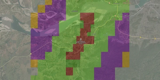
Guwahati airport funnel zone restrictions apply across a 56 km radius from Lokpriya Gopinath Bordoloi International Airport's Aerodrome Reference Point, because LGBIA operates under Instrument Flight Rules. The governing instrument is the Colour Coded Zoning Map published by AAI under GSR 751(E), 2015. It assigns a Permissible Top Elevation in metres AMSL to every grid square in the zone. The airport sits at Borjhar at an elevation of approximately 49 m AMSL, with a single runway oriented 02/20 (north-south).
The AMSL Trap: Why Guwahati Airport Height Restrictions Catch Buyers Off Guard
Guwahati's terrain is not flat. Plots on slopes in Jalukbari, Azara, or areas toward the Kamakhya hillside sit at higher ground elevations than the airport itself, which means their AMSL building ceiling is consumed faster than buyers expect. The critical number is not floors: it is the Permissible Top Elevation from the CCZM grid minus your plot's own ground elevation in metres AMSL.
Permitted Building Heights by Funnel Zone Surface (Guwahati)
The table below shows how permitted building height works across the key Obstacle Limitation Surfaces around Guwahati airport's runway 02/20.
Zone Type
Distance from Runway
Height Rule
AAI NOC Required?
Inner Horizontal Surface
Within ~4 km of runway ends
Max ~45 m AGL
Yes, if PTE is exceeded
Approach / Funnel Surface
Along runway 02/20 axis, up to ~9 km
2% of distance from runway edge
Mandatory in all cases
Conical Surface
4-15 km from ARP
Gradient slopes upward at 5%
Depends on CCZM grid colour
Outer Horizontal Surface
15-56 km from ARP (IFR airport)
Generally permissive; local bylaws dominate
Required if proposed height exceeds PTE
Guwahati's AAI NOC office is one of only nine designated regional offices in India, meaning all complex height clearance decisions for Northeast India pass through the Borjhar office. AAI takes a median of 25 days to approve NOC applications and approves only 58% of all processed applications nationwide. If your seller or developer has not obtained an AAI height NOC and your plot falls in a red-grid CCZM area, no municipal building permit from Guwahati Metropolitan Development Authority overrides that gap. Confirm the CCZM grid classification before signing anything.
Borjhar, Azara, Jalukbari: Which Guwahati Corridors the Funnel Zone Affects Most
Guwahati's fastest-growing real estate corridors run along the NH27 and NH17 alignments radiating from the city, and the airport's north-south runway orientation means the funnel zone bites hardest directly north and south of Borjhar. Areas east and west of the runway sit under the conical and horizontal surfaces, where height rules are more permissive but still apply.
The table below maps key Guwahati corridors against their funnel zone constraint profile.
Corridor / Locality
Airport Distance
Constraint Level
Growth Driver
Key Risk
Borjhar / Azara
0–3 km (immediate vicinity)
Very High (approach funnel)
Airport-linked demand; T2 terminal commissioned
Severe height caps; multi-storey development constrained
Jalukbari
~18 km (east-northeast)
Low-Moderate
IIT Guwahati proximity; NH27 access
Elevated terrain may reduce AGL allowance; check individual CCZM grid
Beltola / Six Mile
~20-22 km (east)
Low
GS Road commercial spine; Dispur proximity
Beyond critical funnel; local bylaws dominate
Lokhra / Dharapur
~15-17 km (east)
Low-Moderate
Affordable residential; expanding urban fringe
Verify CCZM grid; spot variation possible
Narengi / Garchuk
~12-14 km (northeast)
Moderate
NH17 / Ring Road alignment; industrial growth
Conical surface applies; height cap depends on site elevation
Borjhar is the most misunderstood corridor. Brokers marketing plots in Azara and Garal within 2–3 km of the runway ends promote them as airport-facing growth plays without disclosing that the 2% funnel slope formula limits buildings within 1,000 m of the runway edge to just 20 m of height above ground, roughly five to six floors. At 2,000 m from the runway edge, the ceiling rises to 40 m. These are hard limits enforced by GSR 751(E), not municipal discretion.
Was this layer helpful?
Anything wrong, outdated, or missing we want to hear it.
For Land Owners & Agents
Looking to sell your land in Assam?
I want to sell my land in Guwahati
10:32
Plz share your Land's location - We will list it on 1acre map, for Free.
10:32

For Land Buyers
Browse all verified lands & plots in Assam
Every listing goes through our Preliminary Verification Process.
More Layers in Assam
See all 3 layers
Guwahati GMDA Masterplan: Zone Check and Land Use Guide
View Guwahati Masterplan as a live map overlay – check any plot's land use zone for free on 1acre.in. Guwahati GMDA Mast...

Assam Survey Number Map — Find Any Plot's Dag Number Free | 1acre.in
See any plot's survey (dag) number in Assam on a free live map. Dag number, Jamabandi, Myadi patta and Dharitree explain...
More Layers in Assam
Guwahati GMDA Masterplan: Zone Check and Land Use Guide
View Guwahati Masterplan as a live map overlay – check any plot's land use zone for free on 1acre.in. Guwahati GMDA Mast...
Assam Survey Number Map — Find Any Plot's Dag Number Free | 1acre.in
See any plot's survey (dag) number in Assam on a free live map. Dag number, Jamabandi, Myadi patta and Dharitree explain...