Guwahati GMDA Masterplan: Zone Check and Land Use Guide
Guwahati Masterplan Preview
Try the Guwahati GMDA Masterplan on the map
Sign in once and explore the layer for a full day.
- No card details needed
- Find nearby verified lands for sale
Overview
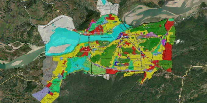
The Guwahati GMDA Master Plan 2025 governs land use across the 328 sq km Guwahati Metropolitan Area (GMA), administered by the Guwahati Metropolitan Development Authority (GMDA) under the GMDA Act 1985. Published July 7, 2009 and notified by the Government of Assam, it divides every plot in the GMA into one of nine use zones: Residential, Commercial, Industrial, Public and Semi-Public, Transportation, Green Belt, Eco-Sensitive/Eco-Friendly, Composite Use I, and Composite Use II. This layer, available to Premium subscribers on 1acre, maps those zones onto satellite imagery so you can cross-check any listing before approaching a seller.
Eco-Sensitive Zone Guwahati: The Zone That Kills Building Permission
The single costliest mistake buyers make in Guwahati is purchasing land in the Eco-Sensitive Zone without confirming zone status first. Plots in the zone trade at residential-land prices but cannot receive a GMDA building permit, and sellers rarely volunteer this fact.
The Master Plan defines the Eco-Sensitive Zone precisely: all notified forests, water bodies, and rivers, plus the entire area west of the Gorchuk-Pamohi Road, south of the National Highway bypass, up to Deepar Beel. This is not a vague environmental designation. It is a hard boundary on the GMDA proposed land use map (document 12.2), downloadable from the GMDA website. The Eco-Sensitive Zone accounts for 26% of the entire GMA land area, which means roughly one in four plots in the city's periphery carries this restriction.
The table below shows what each zone permits and what requires special authority approval.
Zone Code
Permitted Use
Construction Allowed?
Requires Special Permission?
R – Residential
Dwellings, schools, clinics, convenience shops
Yes, standard permit
No
C – Commercial
Offices, retail, hotels, banks
Yes, standard permit
No
I – Industrial
Factories, warehouses, specific industries
Yes, within Annex I list
No
P – Public/Semi-Public
Govt offices, hospitals, colleges
Yes
No
G – Green Belt
Parks, playgrounds, petrol pumps on NH only
No new construction
Yes, from GMDA
E – Eco-Sensitive
Notified forest, water bodies, Deepar Beel buffer
No new construction
Not granted for residential
Eco-Friendly (sub-zone of E)
Tourism, bungalow-type construction, integrated township
Limited: max 33% coverage, FAR 150, EIA clearance, 20+ ha minimum
Yes, full EIA required
CI – Composite Use I
Residential + commercial + public uses
Yes
No
CII – Composite Use II
Residential + commercial + public + existing industrial
Yes
No
A legal complaint on record shows that Assam State Co-operative Housing Federation (Housefed) sold plots in an area that was subsequently notified as Eco-Sensitive Zone, leaving buyers with land on which no building permission could be issued. The matter was referred to GMDA and the Gauhati High Court. The zone boundary existed in the plan before those plots were sold. Buyers who check the 1acre GMDA masterplan layer before purchase avoid this outcome entirely.
Guwahati Ring Road Land Corridors: Where the Master Plan Meets Live Infrastructure
Guwahati's most investable corridors right now sit at the intersection of two variables: Composite Use or Residential zone classification under the GMDA Master Plan 2025, and proximity to the ring road and bridge projects now under construction.
The 93 km Guwahati Ring Road (appointed date January 23, 2026, awarded to DRA Infracon at ₹57.30 billion) runs from Baihata Chariali via Kurua and Chandrapur to Sonapur. Construction started from the Baihata Chariali end in January 2026. The northern bypass section alone is 56 km of new greenfield alignment, and a 4-lane Kurua-Narengi bridge over the Brahmaputra is part of the same package. A separate 6-lane Guwahati-North Guwahati Bridge will cut cross-river travel time from one hour to 15 minutes. The JLL December 2025 report identifies Azara, Baihata, and Narengi as the three corridors that will see the most direct land value uplift.
The table below maps the current investment profile of key corridors against their GMDA zone classification.
Corridor / Locality
GMDA Zone
Growth Driver
Known Risk
Azara
Residential / Composite Use
Ring road access, airport proximity
Verify flood-plain status; check masterplan map
Narengi
Residential / Composite Use
Kurua-Narengi bridge north bank landing
Confirm E zone boundary; west-of-road plots may be Eco-Sensitive
Baihata Chariali
Residential
Ring road starting point, Greenfield alignment
Peripheral, longer appreciation timeline
North Guwahati (Amingaon belt)
Residential / Green Belt
6-lane bridge, 25-30% appreciation projected
Some Green Belt plots sold as residential; verify zone before purchase
Beltola / Khanapara
Composite Use II
Established market, GS Road commercial pull
Higher entry prices; less upside than ring road belt
Jalukbari
Residential / Composite Use I
Gauhati University, institutional demand, 3.9% rental yield
Tetelia corridor has active fake sale deed cases on record
The most misread corridor is the Narengi belt. Plots west of the Gorchuk-Pamohi Road in this zone fall into the Eco-Sensitive classification regardless of how a seller categorises them. Cross-referencing the GMDA proposed land use map (12.2) against any listing in this belt is not optional: it is the only way to confirm what you are actually buying.
Was this layer helpful?
Anything wrong, outdated, or missing we want to hear it.
For Land Owners & Agents
Looking to sell your land in Assam?
I want to sell my land in Guwahati
10:32
Plz share your Land's location - We will list it on 1acre map, for Free.
10:32

For Land Buyers
Browse all verified lands & plots in Assam
Every listing goes through our Preliminary Verification Process.
More Layers in Assam
See all 3 layers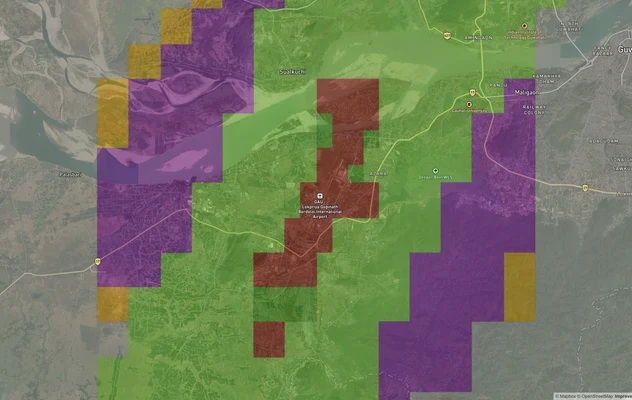
Guwahati Air Funnel Zones: Building Height Restrictions
View Guwahati Air Funnel Zones on a live map – check height clearance restrictions on any plot for free on 1acre.in. Guw...

Assam Survey Number Map — Find Any Plot's Dag Number Free | 1acre.in
See any plot's survey (dag) number in Assam on a free live map. Dag number, Jamabandi, Myadi patta and Dharitree explain...
More Layers in Assam
Guwahati Air Funnel Zones: Building Height Restrictions
View Guwahati Air Funnel Zones on a live map – check height clearance restrictions on any plot for free on 1acre.in. Guw...
Assam Survey Number Map — Find Any Plot's Dag Number Free | 1acre.in
See any plot's survey (dag) number in Assam on a free live map. Dag number, Jamabandi, Myadi patta and Dharitree explain...