Banur Masterplan
Banur Masterplan Preview
Try the Banur Masterplan on the map
Sign in once and explore the layer for a full day.
- No card details needed
- Find nearby verified lands for sale
Overview
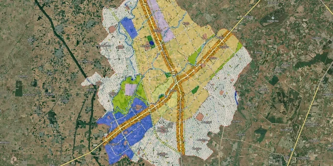
The Banur LPA Master Plan 2031 governs land use across 10,380.2 ha in the south-western corner of the Greater Mohali Region (GMR), Punjab, administered by GMADA. Prepared by JURONG Consultants for the Department of Town and Country Planning, Punjab, it designates Banur as the GMR's primary institutional hub, with residential use as the dominant land allocation (18.1% of total area), followed by mixed use and institutional zones (8%). Two roads, NH 64 and MDR A, anchor the LPA's spatial structure. This page covers the premium Banur Masterplan layer on 1acre, what each zone permits, the regulatory traps buyers encounter, and the corridors where this plan directly drives land value.
Growth Corridors and Micro-Markets Under the Banur Masterplan
The Banur LPA Master Plan 2031 makes a deliberate planning bet: institutional use as the economic engine, residential use as the supporting layer, and industry as a secondary driver in a contained western zone. That hierarchy creates distinct investment profiles across the LPA.
The table below maps the primary corridors to their zone designation and investment context, based entirely on facts sourced from the Banur LPA Master Plan report and GMADA plan map:
Corridor / Locality
Zone (Master Plan 2031)
Growth Driver
Known Risk
NH-64 (Patiala Road) frontage
Mixed Use + Residential
Primary road frontage; direct connectivity to Zirakpur, Chandigarh, Patiala; commercial and residential activity already established
Road widening or PR-1 GMADA Expressway alignment may affect parcels near frontage; verify right-of-way with GMADA
MDR A corridor
Mixed Use + Residential
Second main road spine of the LPA; serves existing built-up municipal area of 104.1 ha
Parcels near the intersection of NH-64 and MDR-A carry mixed-use overlay; check zone designation before assuming pure residential rights
Western industrial belt
Industrial (pharma/distillery)
Existing pharmaceutical and distillery industries; dedicated treatment plant within zone
No residential development permitted; scattered brick kilns near villages; truck terminal encroachment flagged in Master Plan report
Educational cluster (western LPA, NH-64 alignment)
Institutional
Concentration of medical, nursing, and engineering colleges along NH-64; Master Plan allocates 8% of LPA for institutional use
Land around institutional clusters is plan-protected; residential subdivision without CLU is not permitted
Azizpur / Khizergarh (Sub Tehsil Banur)
Residential colony zone
GMADA-licensed affordable colony project; proximity to NH-64 and Zirakpur
GMADA issued a public notice (2024) regarding dues default by the developer; verify current licence status before any transaction
The most misunderstood corridor is the educational cluster along NH-64. The Banur LPA Master Plan explicitly designates this zone for institutional use; it is not a residential buffer that can be colonised with plotted layouts. Buyers attracted by proximity to Chitkara University, Gian Sagar Medical College, and Plaksha University must verify that their specific khasra number carries residential or mixed-use designation before they assume building rights.
Was this layer helpful?
Anything wrong, outdated, or missing we want to hear it.
For Land Owners & Agents
Looking to sell your land in Punjab?
I want to sell my land in Punjab
10:32
Plz share your Land's location - We will list it on 1acre map, for Free.
10:32

For Land Buyers
Browse all verified lands & plots in Punjab
Every listing goes through our Preliminary Verification Process.
More Layers in Punjab
See all 8 layers
Derabassi Masterplan
View Derabassi Masterplan as a live map overlay – check any plot's land use zone for free on 1acre.in. Derabassi LPA Mas...
Kharar Masterplan
View Kharar Masterplan as a live map overlay – check any plot's land use zone for free on 1acre.in. Kharar masterplan zo...
Mohali - SAS Nagar Masterplan
View Mohali - SAS Nagar Masterplan as a live map overlay – check any plot's land use zone for free on 1acre.in. Mohali S...
More Layers in Punjab
Derabassi Masterplan
View Derabassi Masterplan as a live map overlay – check any plot's land use zone for free on 1acre.in. Derabassi LPA Mas...
Kharar Masterplan
View Kharar Masterplan as a live map overlay – check any plot's land use zone for free on 1acre.in. Kharar masterplan zo...
Mohali - SAS Nagar Masterplan
View Mohali - SAS Nagar Masterplan as a live map overlay – check any plot's land use zone for free on 1acre.in. Mohali S...