Mohali - SAS Nagar Masterplan
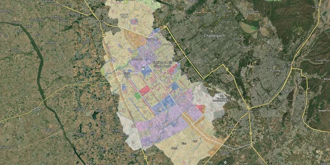
Mohali Sas Nagar Masterplan Preview
Try the Mohali - SAS Nagar Masterplan on the map
Sign in once and explore the layer for a full day.
- No card details needed
- Find nearby verified lands for sale
Overview
The Mohali SAS Nagar GMADA master plan land buying decision starts with one document: the GMADA Master Plan 2006–2031, prepared for the Greater Mohali Area Development Authority by Jurong Consultants. It covers the entire SAS Nagar local planning area and defines every zone, from residential and mixed-use to rural and agriculture, industry and technology, and airport reserve sites. The plan is live on 1acre as a Premium layer, letting you cross-reference any listed plot against its official zone before you call a broker. This page explains what the plan contains, where the regulatory traps are, and which corridors have the most movement right now.
Aerotropolis, Airport Road, and New Chandigarh: The Corridors Driving Mohali Land Values
Three corridors dominate land value movement in SAS Nagar right now. Each sits in a different risk and maturity profile.
The Airport Road corridor, running from the Shaheed Bhagat Singh International Airport through IT City and into Aerocity, is the most mature. GMADA's ongoing projects list confirms active construction of the 200-foot wide road from the Aerocity junction to the Kharar-Banur road (PR-9), and a direct road connecting Aerocity to the airport itself. Plots here are priced to reflect existing infrastructure.
The Aerotropolis corridor is the active acquisition zone. GMADA has initiated land acquisition for Blocks E through J, covering approximately 3,500 acres along the Banur-Zirakpur road under the Right to Fair Compensation Act of 2013. This is the expansion of Aerocity, planned to deliver around 8,600 residential plots ranging from 100 to 2,000 sq yards, alongside commercial, institutional, and industrial zones. Buyers here are pricing in future development, not current infrastructure.
Corridor
Status
Zone Classification
Key Risk
Airport Road / Aerocity (Sectors 66–68)
Developed
Residential, Mixed-Use, Airport Facilities
Pricing already elevated
Aerotropolis Blocks A–D (Banur-Zirakpur Road)
Under development
Residential, Commercial, Institutional
Possession timelines unclear
Aerotropolis Blocks E–J
Active acquisition
Reserved (under Land Act 2013)
Litigation risk; Block A under dispute
New Chandigarh / Mullanpur
Planned
Residential, Low-Density, PLPA Green
PLPA land cannot be built on
IT City (Sectors 82–83 Alpha)
Partly developed
Industry, Technology, R&D
Conversion required for non-IT use
The corridor most buyers get wrong is Mullanpur. The GMADA master plan allocates approximately 33% of New Chandigarh's total area to green space, including PLPA (Punjab Land Preservation Act) land. PLPA land looks like developable residential land on broker maps but carries a statutory restriction on construction. If your plot sits inside a PLPA buffer, no building plan will be approved regardless of what the colony license says.
Was this layer helpful?
Anything wrong, outdated, or missing we want to hear it.
For Land Owners & Agents
Looking to sell your land in Punjab?
I want to sell my land in Punjab
10:32
Plz share your Land's location - We will list it on 1acre map, for Free.
10:32

For Land Buyers
Browse all verified lands & plots in Punjab
Every listing goes through our Preliminary Verification Process.
More Layers in Punjab
See all 8 layers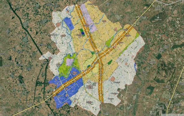
Banur Masterplan
View Banur Masterplan as a live map overlay – check any plot's land use zone for free on 1acre.in. Banur LPA Master Plan...
Derabassi Masterplan
View Derabassi Masterplan as a live map overlay – check any plot's land use zone for free on 1acre.in. Derabassi LPA Mas...
Kharar Masterplan
View Kharar Masterplan as a live map overlay – check any plot's land use zone for free on 1acre.in. Kharar masterplan zo...
More Layers in Punjab
Banur Masterplan
View Banur Masterplan as a live map overlay – check any plot's land use zone for free on 1acre.in. Banur LPA Master Plan...
Derabassi Masterplan
View Derabassi Masterplan as a live map overlay – check any plot's land use zone for free on 1acre.in. Derabassi LPA Mas...
Kharar Masterplan
View Kharar Masterplan as a live map overlay – check any plot's land use zone for free on 1acre.in. Kharar masterplan zo...