Zirakpur Masterplan
Overview
Every plot in Zirakpur sits inside a zone defined by the Zirakpur LPA Master Plan 2031, prepared under GMADA (Greater Mohali Area Development Authority) and governed by PUDA. The Local Planning Area covers 38.29 sq km and is one of six LPAs under the Greater Mohali Region. Zirakpur sits 12 km from Chandigarh, at the crossroads of NH-5, NH-7, and the Ambala-Chandigarh highway. That location explains both the price appreciation and the volume of unauthorized colonies that have sprouted here. This page covers the zone framework, the unauthorized colony problem, and the corridors where real value is moving.
Lohgarh, Baltana, Peer Muchalla: Where Zone Status Divides the Investable from the Speculative
The Zirakpur LPA Master Plan divided the 38.29 sq km into four growth clusters. The western cluster around the Ambala highway was designated for airport and business growth. The northern cluster was set as the regional centre. The eastern cluster, including Bir per Machhaila, was planned for institutional, Business Park, and FEZ growth. The southern residential pockets absorbed the bulk of workforce housing demand.
Lohgarh Road and Singhpura are in the northern cluster and were already flagged in the revised master plan for deviations against the 2031 plan. Residential colonies here sit in areas that were mapped differently. Baltana, on the Patiala Road NH-7 corridor, is genuinely within residential zone coverage and has seen the most consistent demand from workers commuting to Chandigarh and Mohali. Peer Muchalla is where the Zirakpur-Panchkula bypass originates: the Rs 800 crore NHAI project starts from McDonald's on the Ambala-Zirakpur highway, passes through Peer Muchalla, Sanoli, and Gazipur, and terminates near Sector 4 Panchkula. Land within the 17 km bypass alignment was under NHAI acquisition; any plot marketed along that stretch needs an acquisition status check before purchase.
On the western side, the Rs 3,167 crore Chandigarh-Ambala Greenfield Corridor (61.23 km, 95% complete as of mid-2025) has its connectivity impact felt most in the Ambala Highway corridor, where commercial and mixed-use plots have appreciated significantly ahead of the expressway opening.
Corridor / Locality
Zone Context (Zirakpur LPA 2031)
Growth Driver
Known Risk
Lohgarh / Singhpura
Residential (with documented deviations in 2031 plan)
Northern regional centre cluster
Plan deviations flagged; verify colony license
Baltana / Patiala Road (NH-7)
Residential
Chandigarh commuter belt, NH-7 connectivity
Unauthorized colonies mixed with licensed ones
Peer Muchalla / Gazipur
Residential; bypass alignment
Zirakpur-Panchkula bypass route
NHAI acquisition risk on specific plots
Bir per Machhaila
FEZ / Eastern cluster
Business Park, institutional
Residential colonies built on FEZ-designated land
Ambala Highway corridor
Commercial / mixed-use
Chandigarh-Ambala expressway connectivity
Acquisition land in expressway alignment
Bir per Machhaila is the most misunderstood corridor. It sits inside the FEZ eastern cluster designation, but residential plots have been sold there for years. The zone designation has not changed. Without a CLU, those plots cannot be legally used for residential construction.
Was this layer helpful?
Anything wrong, outdated, or missing we want to hear it.
For Land Owners & Agents
Looking to sell your land in Punjab?
I want to sell my land in Punjab
10:32
Plz share your Land's location - We will list it on 1acre map, for Free.
10:32

For Land Buyers
Browse all verified lands & plots in Punjab
Every listing goes through our Preliminary Verification Process.
More Layers in Punjab
See all 8 layers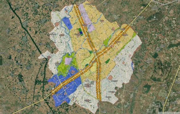
Banur Masterplan
View Banur Masterplan as a live map overlay – check any plot's land use zone for free on 1acre.in. Banur LPA Master Plan...
Derabassi Masterplan
View Derabassi Masterplan as a live map overlay – check any plot's land use zone for free on 1acre.in. Derabassi LPA Mas...
Kharar Masterplan
View Kharar Masterplan as a live map overlay – check any plot's land use zone for free on 1acre.in. Kharar masterplan zo...
More Layers in Punjab
Banur Masterplan
View Banur Masterplan as a live map overlay – check any plot's land use zone for free on 1acre.in. Banur LPA Master Plan...
Derabassi Masterplan
View Derabassi Masterplan as a live map overlay – check any plot's land use zone for free on 1acre.in. Derabassi LPA Mas...
Kharar Masterplan
View Kharar Masterplan as a live map overlay – check any plot's land use zone for free on 1acre.in. Kharar masterplan zo...