Kharar LPA Master Plan 2031: Zone Check & Land Use Guide
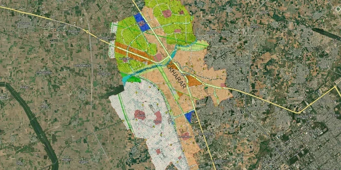
Kharar Masterplan Preview
Try the Kharar LPA Master Plan 2031 on the map
Sign in once and explore the layer for a full day.
- No card details needed
- Find nearby verified lands for sale
Overview
The Kharar LPA Master Plan 2031 is the governing land-use document for Kharar and its surrounding villages in SAS Nagar district. Prepared by the Greater Mohali Area Development Authority (GMADA) with Jurong Consultants Pte Ltd, the plan classifies every parcel across the Kharar Local Planning Area into residential zones (R1 through R6), mixed use, institutional, agricultural, and other categories. Before you negotiate price or sign any agreement on land in Kharar, this plan tells you what can legally be built, at what density, and whether a Change of Land Use is required. This page covers zone codes, regulatory traps specific to SAS Nagar, the active growth corridors, and how to use 1acre's premium map tools to verify your plot before committing.
NH-21 (renumbered as NH-205 since 2010), the IT City–Kurali corridor, and which Kharar pockets have real growth drivers
Not all Kharar land is equal. Three corridors have documented infrastructure backing, and two carry speculative risk that isn't always disclosed.
The IT City–Kharar–Kurali Greenfield Corridor is the most substantive driver. The IT City Chowk–Kharar–Kurali corridor opened to traffic on 22 December 2025 as Package-2 of the ₹3,167 crore Chandigarh-Ambala six-lane greenfield highway. It was built over 215 hectares involving 2,200 landowners and is access-controlled at 100 kmph. This is an active, operating corridor — not a speculative one. This corridor directly links Mohali's IT City development zone through Kharar toward Kurali, and the Kharar LPA 2031 plan designates a Future Development Corridor (Mixed Use) running along NH-21 toward Ropar. Land within the Mixed Use corridor on NH-21 benefits from permitted commercial and residential use without a separate CLU, provided the colony is licensed.
The table below maps active corridors against their status and planning zone.
Corridor / Locality
LPA 2031 Zone
Active Growth Driver
Known Risk
NH-21 corridor toward Ropar
Mixed Use (Future Development Corridor)
IT City–Kurali NHAI corridor; land acquisition completed
Plots outside licensed colonies still need CLU
Kharar–Landran Road
Residential (R3/R4)
Proximity to CGC Landran, student rental demand
Crowded development, verify licensed colony status
Sunny Enclave / Sector 125
Residential (R2/R3)
Established residential zone, direct NH-5 access
Premium pricing; limited raw land left
Siswan village fringe
Rural/Agriculture or PLPA-regulated
None; active HC enforcement and demolition orders
High: do not transact without GMADA clearance
MDR-A / PR-2 junction areas
Mixed Use / Institutional
Road widening proposals; proximity to SAS Nagar HQ
Some parcels within Periphery Control Act zone
The most misunderstood corridor is Siswan and its surrounding villages. Brokers market this area as "Chandigarh fringe" land with high appreciation potential. What they omit: this area is under active Punjab and Haryana High Court monitoring, with GMADA conducting a district-wide survey of violations through March 31, 2026, and FIRs being filed against landowners who built without sanction.
Was this layer helpful?
Anything wrong, outdated, or missing we want to hear it.
For Land Owners & Agents
Looking to sell your land in Punjab?
I want to sell my land in Punjab
10:32
Plz share your Land's location - We will list it on 1acre map, for Free.
10:32

For Land Buyers
Browse all verified lands & plots in Punjab
Every listing goes through our Preliminary Verification Process.
More Layers in Punjab
See all 8 layers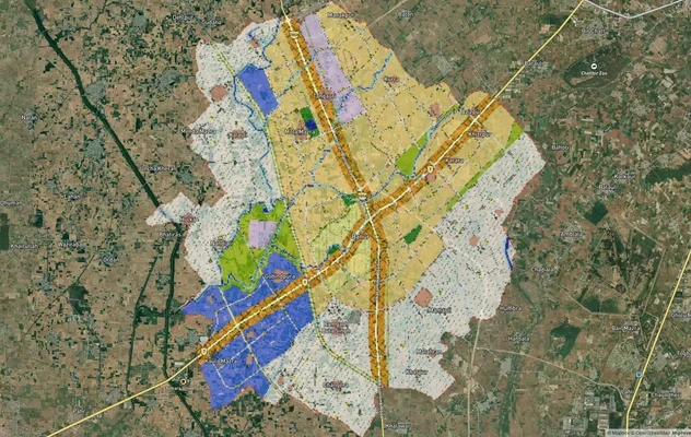
Banur Masterplan
View Banur Masterplan as a live map overlay – check any plot's land use zone for free on 1acre.in. Banur LPA Master Plan...
Derabassi Masterplan
View Derabassi Masterplan as a live map overlay – check any plot's land use zone for free on 1acre.in. Derabassi LPA Mas...
Mohali - SAS Nagar Masterplan
View Mohali - SAS Nagar Masterplan as a live map overlay – check any plot's land use zone for free on 1acre.in. Mohali S...
More Layers in Punjab
Banur Masterplan
View Banur Masterplan as a live map overlay – check any plot's land use zone for free on 1acre.in. Banur LPA Master Plan...
Derabassi Masterplan
View Derabassi Masterplan as a live map overlay – check any plot's land use zone for free on 1acre.in. Derabassi LPA Mas...
Mohali - SAS Nagar Masterplan
View Mohali - SAS Nagar Masterplan as a live map overlay – check any plot's land use zone for free on 1acre.in. Mohali S...