Dadra and Nagar Haveli Masterplan
Dadra And Nagar Haveli Masterplan Preview
Try the Dadra and Nagar Haveli Masterplan on the map
Sign in once and explore the layer for a full day.
- No card details needed
- Find nearby verified lands for sale
Overview
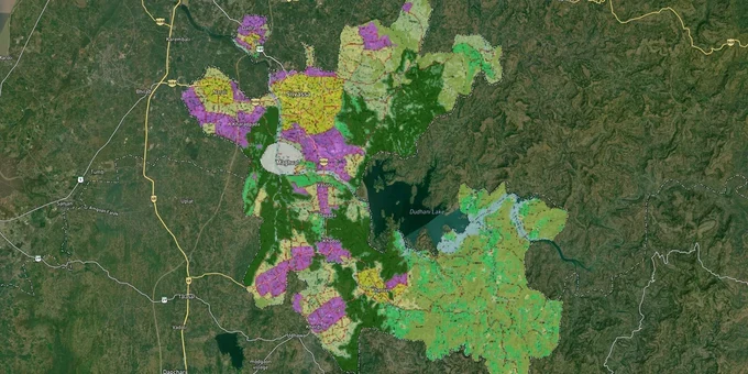
The Dadra and Nagar Haveli masterplan land zone is governed by the Revised Outline Development Plan (ODP), administered by the DNHPDA under the Town and Country Planning Act, 1974. The authority's jurisdiction spans 491 sq km, covering 1 municipal council, 6 census towns, and 66 villages across 20 Panchayats. The General Development Rules 2023 (GDR 2023), gazetted under Sections 30, 140(y), and 141 of the Act, define all permissible uses, FSI limits, and road-width requirements. This page covers how to read your plot's zone, the traps that catch buyers, and where growth is actually happening.
Silvassa's Growth Corridors: Khanvel, Naroli, Amli, and the Industrial Belt
DNH's real estate growth is concentrated along three distinct corridors, each with a different risk-return profile. Buyers who treat the entire 491 sq km as equivalent are making an expensive mistake.
The table below maps corridor character based on sourced data from active listings and the DNHPDA's planning frameworks.
Corridor / Locality
Zone Character
Growth Driver
Known Risk
Khanvel Road
Mixed residential and industrial
Luxury residential demand; large plot sizes
Distance from Silvassa core: water shortage complaints
Naroli Road / Naroli
Industrial and residential fringe
Industrial estate proximity; affordable housing
Pollution from nearby industrial units; active road widening near Dhapsa village
Amli / Amli Ind. Estate
Industrial N.A. land dominant
Established manufacturing cluster: Silvassa Phase II
Limited residential suitability; primarily industrial-zoned
Sayli Road
Mixed large residential plots available
Namo Sports Complex proximity: green land
Some plots still agricultural; N.A. conversion required
Khadoli / Masat / Piparia
Emerging; early-stage
Industrial estate expansion; lower per-square-meter rates
Infrastructure incomplete; verify DNHPDA layout approval
Tokarkhada / Samarvani
Urban fringe residential
Proximity to Silvassa town core; affordable pricing
Compact plots: verify approved colony status
The most misunderstood corridor is Amli. Industrial N.A. land here carries higher per-square-meter rates (up to ₹6,000/sq m quoted in active listings) precisely because it already has N.A. status and construction permission. Buyers who find "cheaper" Amli land without a confirmed N.A. status are not getting a deal; they are buying an agricultural plot that cannot legally be developed for industry or residence without going back to the Collector.
Was this layer helpful?
Anything wrong, outdated, or missing we want to hear it.
For Land Owners & Agents
Looking to sell your land in The Dadra And Nagar Haveli And Daman And Diu?
I want to sell my land in Daman and Diu
10:32
Plz share your Land's location - We will list it on 1acre map, for Free.
10:32

For Land Buyers
Browse all verified lands & plots in The Dadra And Nagar Haveli And Daman And Diu
Every listing goes through our Preliminary Verification Process.
More Layers in The Dadra And Nagar Haveli And Daman And Diu
See all 5 layers
Daman and Diu Masterplan
View Daman and Diu Masterplan as a live map overlay – check any plot's land use zone for free on 1acre.in. Daman Distric...
Daman CRZ
View Daman CRZ alignment as a live map overlay – check land acquisition risk and plot proximity free on 1acre.in.
Diu CRZ
View Diu CRZ alignment as a live map overlay – check land acquisition risk and plot proximity free on 1acre.in.
More Layers in The Dadra And Nagar Haveli And Daman And Diu
Daman and Diu Masterplan
View Daman and Diu Masterplan as a live map overlay – check any plot's land use zone for free on 1acre.in. Daman Distric...
Daman CRZ
View Daman CRZ alignment as a live map overlay – check land acquisition risk and plot proximity free on 1acre.in.
Diu CRZ
View Diu CRZ alignment as a live map overlay – check land acquisition risk and plot proximity free on 1acre.in.