Daman and Diu Masterplan
Daman And Diu Masterplan Preview
Try the Daman and Diu Masterplan on the map
Sign in once and explore the layer for a full day.
- No card details needed
- Find nearby verified lands for sale
Overview
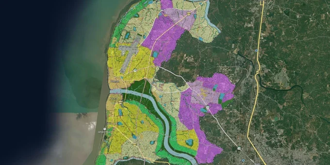
Every plot in Daman has its development rights set by the Revised Regional Plan 2005-2021 of Daman District, prepared under the Goa, Daman and Diu Town and Country Planning Act, 1974. The Planning and Development Authority Daman (PDAD), constituted in 2012 under Section 20 of the Daman and Diu Town and Country Planning (Amendment) Regulation, 1999, is the statutory body that issues layout approvals and building permits across the entire Daman planning area. That planning area divides the district into two well-known halves, Moti Daman and Nani Daman, split by the Daman Ganga River. Two zone types cut across everything buyers think they understand about land here: the CRZ overlay and the NA permission requirement for agricultural land. This page covers both, along with the corridors where genuine residential and industrial demand is concentrated.
CRZ Restrictions and NA Permission: The Two-Zone Traps That Catch Most Daman Land Buyers
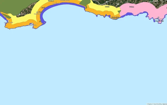
Daman sits on the Arabian Sea coast with the Kolak River to the north and the Kala Nadi to the south. That geography means a significant portion of the district falls under the Coastal Regulation Zone under the CRZ Notification 2019. The Daman and Diu Coastal Zone Management Authority, headquartered at Moti Daman, has published the CRZ Map of Daman and Diu, which shows CRZ-1A, CRZ-II, and CRZ-III designations across the district. PDAD's own Town Planning Scheme documents confirm that areas like Khariwad in Nani Daman carry a CRZ-1A overlay directly on top of the Core Area and Gaothan Zone. CRZ-1A prohibits any new construction. Land sold near the Devka or Jampore beachfronts as "residential plots" frequently sits within the No Development Zone under CRZ-IIIA or CRZ-IIIB, where the NDZ extends 50 meters or 200 meters from the High Tide Line depending on population density.
The second trap is NA permission. The Development Control Rules 2005 for Daman District, notified vide No. 20/LU-PRP-00/176 dated 12th July 2007, make clear that any agricultural land must obtain non-agricultural permission from the Collector before it can be used for residential, commercial, or industrial construction. Without a valid NA order from the Collector's office, a building plan submission to PDAD will not be accepted. The Suo-Motu publication of the Town and Country Planning Department confirms this is one of the department's core functions: "Technical Scrutiny and inspection of the site from planning point of view for proposal of N.A. Permission of land, received from Collector's Office."
The table below maps the key zone types under the Daman Regional Plan and what each means at the point of purchase.
Zone
Permitted Use
Key Restriction
Common Risk
Residential / Core Area
Housing, mixed residential
PDA building permit required
CRZ-1A overlay in Khariwad and riverfront areas
Gaothan / Gamtal
Village settlement, limited residential
GDR 2023 governs setbacks and height
Often sold as open residential without checking CRZ overlap
Industrial Zone
Manufacturing, warehousing
PDAD layout or industrial estate sanction
Marketed to residential buyers in labour housing corridors
Agricultural
Farming only
NA permission from Collector mandatory before any construction
Sold without NA as "plot," construction blocked
CRZ-1A / River Reserve
No private development
CZMP controls; violations prosecuted under Environment Protection Act, 1986
Beachfront and riverside plots marketed despite prohibition
One document the PDA Daman construction permission checklist demands for every building plan application is the NOC from Coast Guard Authority for height restrictions. This is a separate clearance from the CRZ check, and buyers who close a land deal without anticipating it face delays that can run months before a building permit is issued.
Kachigam, Bhimpore, Dabhel and the Devka Corridor: Where Genuine Demand Sits in Daman
Daman's real estate market is divided by function as much as by geography. Nani Daman hosts the industrial heartland, with manufacturing clusters at Kachigam, Bhimpore, Dabhel, and Dunetha driving a sustained demand for labour housing and ancillary commercial development. Moti Daman carries the administrative and tourism identity of the district, with Devka and Jampore beaches anchoring the coastal leisure demand. Understanding which corridor you are buying in determines whether the transaction makes sense at all.
The Kachigam and Bhimpore belt along the Vapi-Daman Road is the most active industrial corridor. Census towns Kadaiya, Dunetha, and Dabhel sit within this belt. PDAD's TP Schemes 04C and 04I identify Nani Daman as the district's primary area of residential densification pressure, with mushrooming labour housing as an acknowledged planning problem. The General Development Rules 2023, which now govern all building plan submissions across the UT, apply to this corridor. Plots here carry residential development potential but must be verified for the specific zone designation under the Regional Plan before any offer.
The Devka Road corridor in Nani Daman is where tourism-linked residential and hotel development concentrates. Devka village is listed as one of the 15 revenue villages under PDAD's planning jurisdiction. Plots here are consistently marketed for hospitality and weekend residential use, but proximity to Devka Beach brings automatic CRZ scrutiny into every transaction.
Corridor / Locality
Zone Context
Demand Driver
Known Risk
Kachigam, Bhimpore, Dabhel
Industrial / Residential
Manufacturing employment, Vapi-Daman road
CRZ overlay near Kala Nadi; NA permission for agricultural plots
Dunetha, Kadaiya
Residential / Census Town
Labour housing, industrial estate proximity
Haphazard development, building permits on unapproved layouts
Devka Road, Nani Daman
Residential / Tourism
Devka Beach proximity, weekend demand
CRZ restrictions; Coast Guard NOC for height
Moti Daman, Jampore
Core Area / Tourism
Administrative centre, Jampore Beach
CRZ-1A in riverfront and coastal pockets
Jampore is the corridor most buyers misjudge. It appears settled and built up, which leads buyers to assume CRZ-II applies and construction is permitted on the landward side of existing roads. The CRZ classification for any specific survey number in Jampore must still be verified against the published CZMP map, because CRZ-1A overlays exist in portions that appear fully developed at street level.
Was this layer helpful?
Anything wrong, outdated, or missing we want to hear it.
For Land Owners & Agents
Looking to sell your land in The Dadra And Nagar Haveli And Daman And Diu?
I want to sell my land in Dadra and Nagar Haveli
10:32
Plz share your Land's location - We will list it on 1acre map, for Free.
10:32

For Land Buyers
Browse all verified lands & plots in The Dadra And Nagar Haveli And Daman And Diu
Every listing goes through our Preliminary Verification Process.
More Layers in The Dadra And Nagar Haveli And Daman And Diu
See all 5 layers
Daman CRZ
View Daman CRZ alignment as a live map overlay – check land acquisition risk and plot proximity free on 1acre.in.
Dadra and Nagar Haveli Masterplan
View Dadra and Nagar Haveli Masterplan as a live map overlay – check any plot's land use zone for free on 1acre.in. Dadr...
Diu CRZ
View Diu CRZ alignment as a live map overlay – check land acquisition risk and plot proximity free on 1acre.in.
More Layers in The Dadra And Nagar Haveli And Daman And Diu
Daman CRZ
View Daman CRZ alignment as a live map overlay – check land acquisition risk and plot proximity free on 1acre.in.
Dadra and Nagar Haveli Masterplan
View Dadra and Nagar Haveli Masterplan as a live map overlay – check any plot's land use zone for free on 1acre.in. Dadr...
Diu CRZ
View Diu CRZ alignment as a live map overlay – check land acquisition risk and plot proximity free on 1acre.in.