Daman CRZ

Daman Crz Preview
Try the Daman CRZ on the map
Sign in once and explore the layer for a full day.
- No card details needed
- Find nearby verified lands for sale
Overview
The Daman CRZ land map is prepared under the CRZ Notification 2019 by the UT Administration of Dadra and Nagar Haveli and Daman and Diu, with the Coastal Zone Management Authority overseeing its implementation. The CRZ designates coastal land up to 500 metres from the High Tide Line (HTL) and 100 metres along tidal-influenced water bodies as regulated zones.
As of early 2025, the Daman CZMP (Coastal Zone Management Plan) under CRZ Notification 2019 had not received confirmed MoEFCC approval. Buyers should verify whether CRZ 2011 or CRZ 2019 is operative for their specific survey number with the Daman Coastal Zone Management Authority before any transaction.
No Development Zone Distances and CRZ Category Confusion: The Core Risks for Daman CRZ Land Buyers
The most consequential risk in Daman's coastal land market is buying a plot without confirming its CRZ category. Each category carries a different No Development Zone (NDZ) measured from the High Tide Line. Getting the category wrong by even one classification can mean the difference between a buildable plot and land that cannot legally carry any structure.
The governing document is the Coastal Zone Management Plan (CZMP) for Daman, prepared under the CRZ Notification 2019 by the UT Administration. The Daman and Diu Coastal Zone Management Authority is the enforcement body. CRZ clearance for CRZ-I ecologically sensitive areas requires MoEFCC approval at the central level; for CRZ-II and CRZ-III plots, clearance is processed at the UT administration level.
The table below shows the four CRZ categories applicable in Daman and the NDZ distance that applies to each:
CRZ Category
Area Type
No Development Zone (NDZ)
Construction Permitted
CRZ-I
Ecologically sensitive; between LTL (Low Tide Line) and HTL; mangroves
No new construction
Only atomic energy, trans-harbour sea links
CRZ-II
Developed areas within municipal limits up to shoreline
On landward side of hazard line
Buildings permitted; current FSI/FAR (Floor Space Index/Floor Area Ratio) applicable
CRZ-IIIA
Rural areas; population density more than 2,161/sq km
50 metres from HTL
Agriculture; limited public facilities beyond NDZ
CRZ-IIIB
Rural areas; population density less than 2,161/sq km
200 metres from HTL
Agriculture; limited public facilities beyond NDZ
CRZ-IV
Aquatic area up to 12 nautical miles seaward
N/A
Fishing and allied activities only
The Supreme Court's demolition of CRZ-violating high-rise towers in Kochi set a binding precedent: structures built in violation of CRZ limits are liable for court-ordered demolition regardless of sale deed registration or completion certificates. In Daman, where the coastline is the primary development driver, this precedent is directly relevant. Before purchasing any coastal plot, obtain the CZMP-certified zone classification for your specific survey number from the Daman Coastal Zone Management Authority. A sale deed alone does not override a CRZ restriction.
Moti Daman to the Beach Fringe: Which Coastal Zones in Daman Support Legal Development
Daman's land market splits clearly between the developed CRZ-II areas inside the municipal limits and the CRZ-III stretches outside. CRZ-II is where legal construction activity is most viable; CRZ-III demands strict HTL distance verification before any purchase.
The table below shows the key Daman micro-markets by CRZ classification and the realistic signal for buyers in each zone:
Zone / Locality
CRZ Category
Development Signal
Key Risk
Moti Daman (old town; municipal area)
CRZ-II
Buildings permitted; current FSI applicable
Hazard line boundary must be confirmed; no landward setback from hazard line
Nani Daman (commercial and residential belt)
CRZ-II (municipal limit portions)
Established commercial corridor; buildable
Confirm exact municipal limit extent for each survey number
Riverbank near Daman Ganga
CRZ 100m buffer from tidal body
100m NDZ applies along tidal-influenced stretch
No construction within 100m of tidal water body
Coastal belt beyond municipal limit
CRZ-IIIA or IIIB (depending on census density)
50m or 200m NDZ; only agriculture and limited facilities
NDZ width depends on 2011 census density; verify before purchase
Beachfront fringe plots
CRZ-I (if mangrove/sand dune) or CRZ-III
Potentially no-development zone
CRZ-I plots are entirely non-buildable
The CRZ-II designation within Daman's municipal limits is the most reliably developable classification, but even here buyers must confirm that the plot sits on the landward side of the hazard line. CRZ clearance maps in Daman are required at 1:4000 scale for each project site; a general CZMP boundary map is not sufficient for individual plot verification. The Daman Coastal Zone Management Authority maintains the official CZMP map; a certified extract for your survey number from this authority is the only document that definitively establishes which NDZ rule applies.
Was this layer helpful?
Anything wrong, outdated, or missing we want to hear it.
For Land Owners & Agents
Looking to sell your land in The Dadra And Nagar Haveli And Daman And Diu?
I want to sell my land in Dadra and Nagar Haveli
10:32
Plz share your Land's location - We will list it on 1acre map, for Free.
10:32

For Land Buyers
Browse all verified lands & plots in The Dadra And Nagar Haveli And Daman And Diu
Every listing goes through our Preliminary Verification Process.
More Layers in The Dadra And Nagar Haveli And Daman And Diu
See all 5 layers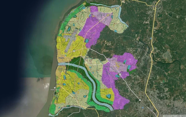
Daman and Diu Masterplan
View Daman and Diu Masterplan as a live map overlay – check any plot's land use zone for free on 1acre.in. Daman Distric...
Dadra and Nagar Haveli Masterplan
View Dadra and Nagar Haveli Masterplan as a live map overlay – check any plot's land use zone for free on 1acre.in. Dadr...
Diu CRZ
View Diu CRZ alignment as a live map overlay – check land acquisition risk and plot proximity free on 1acre.in.
More Layers in The Dadra And Nagar Haveli And Daman And Diu
Daman and Diu Masterplan
View Daman and Diu Masterplan as a live map overlay – check any plot's land use zone for free on 1acre.in. Daman Distric...
Dadra and Nagar Haveli Masterplan
View Dadra and Nagar Haveli Masterplan as a live map overlay – check any plot's land use zone for free on 1acre.in. Dadr...
Diu CRZ
View Diu CRZ alignment as a live map overlay – check land acquisition risk and plot proximity free on 1acre.in.