
Future City is a planned greenfield development south of Hyderabad, governed by the Future City Development Authority under a March 2025 notification. The area is notified. The comprehensive masterplan is not yet finalised. For anyone looking at land here, that distinction is the whole story.
- A 30,000 acre core project between the Srisailam and Nagarjunasagar highways in Rangareddy district
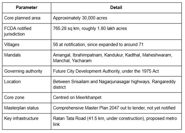
- FCDA governs a notified area of 765.28 sq km, originally 56 revenue villages, since expanded
- The comprehensive masterplan is out to tender, not yet approved
- Villages transferred from both HMDA and DTCP, which changes whose approval is valid
- Large tracts sit in the former conservation zone and need conversion before any layout approval
- Land acquisition from private holders is incomplete and has met resistance elsewhere
What Is Future City Hyderabad
Future City is a government-led greenfield urban project centred on roughly 30,000 acres between the Srisailam and Nagarjunasagar highways in Rangareddy district, south of the Outer Ring Road. It was approved by the Telangana Cabinet in March 2025 and is positioned as a net-zero city and Hyderabad's fourth urban hub after Hyderabad, Secunderabad and Cyberabad. It also appears as Bharat Future City in official and promotional material; both names describe the same project.
The state is attempting to build a new city rather than extend the existing one, which is why a separate authority was created instead of expanding HMDA's plan for the area.
One thing to hold onto throughout. A notified development area and an approved masterplan are different things, and only the first currently exists.
The FCDA and How Governance Works
The Future City Development Authority was constituted as a Special Area Development Authority under Section 3-A of the Telangana Urban Areas (Development) Act, 1975, notifying 56 revenue villages across 7 mandals spanning 765.28 sq km in Rangareddy district as the Future City Area. The mandals are Amangal, Ibrahimpatnam, Kandukur, Kadthal, Maheshwaram, Manchal and Yacharam.
Of the original 56 villages, 36 were excluded from HMDA jurisdiction and 20 came from the Directorate of Town and Country Planning. The area has since expanded, with a further 15 villages reported as added, taking coverage to around 71 revenue villages. Confirm the current notified list before relying on any village count, including this one.
In parallel, HMDA's own jurisdiction was expanded to 1,355 revenue villages across 11 districts, totalling 10,472.72 sq km, extending to the Regional Ring Road.
FCDA vs HMDA, What Changes for Buyers
Villages that were under HMDA have shifted to FCDA control. A layout approved by HMDA before the transfer does not automatically carry the same standing under the new authority. Confirm which body currently governs the specific village before accepting any plot's approval status, and treat pre-2025 approvals as needing verification rather than assumption. The FCDA map layer sets out the village-by-village position.
Masterplan Zones and Land Use Allocation
Reported allocations include an AI and technology hub, a life sciences park, a sports city anchored on a proposed international cricket stadium, the Young India Skill University and education hub, and residential and mixed-use zones. Around 13,973 acres was repurposed from the earlier Hyderabad Pharma City plan, which is why some land use categories carry over from that proposal.
Treat all of this as indicative. FCDA has invited global tenders for the Bharat Future City Comprehensive Master Plan 2047, with a nine-month deadline set and the tender process running through early 2026. A primary masterplan and detailed project report for the 30,000-acre core went to a Singapore-based consultancy. Until a plan is notified, zone boundaries shown in marketing material are projections, not approvals.
Key Infrastructure Driving the Masterplan
The core area centres on Meerkhanpet. The main corridor is the Ratan Tata Road, or Greenfield Radial Road 1, a 41.5 km expressway connecting the ORR at Raviryal to the RRR at Amangal, with Phase 1 covering 19.2 km from Raviryal to Meerkhanpet. It is under construction and not yet operational.
Metro connectivity toward the zone has been discussed as part of broader planning. A dedicated police commissionerate was established in September 2025, and an FCDA headquarters campus has been set up in the field.
The distinction that matters for a buyer is between infrastructure that is operational, under construction, and announced. Those three categories carry very different timelines, and marketing material routinely presents all three the same way.
Future City Hyderabad Masterplan at a Glance
Land Acquisition Status and What It Means for Buyers
Total FCDA jurisdiction runs to roughly 1.80 lakh acres. Within that, about 15,000 acres of government land has been acquired, and around 15,000 acres of forest area is proposed for eco-tourism uses. The government has stated it needs a further 15,000 acres from private landholders, and land pooling is being considered as a mechanism.
Acquisition on this scale has met farmer resistance elsewhere in the state, and that history is relevant context for anyone treating government backing as a guarantee of timeline.
Being inside the Future City boundary does not mean the surrounding land is secured, the zone finalised, or the infrastructure funded. Timelines here should be treated as evolving.
Due Diligence Checklist Before Buying Land Near Future City
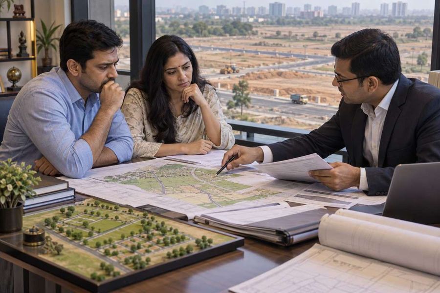
Check the conservation zone first. This is the single biggest trap in this corridor. More than 65,000 acres across the FCDA villages sit in the former HMDA conservation zone. Land conversion is mandatory before FCDA can approve a layout there. It is also why land in parts of Ibrahimpatnam and Maheshwaram is priced below residential-zone land, and why some of it is marketed as future residential without the conversion ever having happened. Ask for the conversion order and the payment receipt, not an assurance.
Confirm the governing authority. FCDA or HMDA, for that specific village, today.
Verify the survey number against the notified village list, not against a marketing map showing the boundary.
Run the standard Telangana restricted-land checks. Assigned land, Section 22A prohibited property, endowment and forest classification all appear in ordinary revenue records in growth corridors, and none of them can be legally sold. The Telangana buyer's guide covers each category.
Check for resettlement plot history, particularly in Ibrahimpatnam mandal, where registrations of resettlement plots from the earlier Pharma City acquisition have been actively disputed.
Pull the encumbrance certificate and the revenue record together. The Telangana EC guide covers the 1983 record limit and why a Nil EC is not automatically reassuring.
Assess real distance from operational infrastructure, not proximity to the boundary. If you have a location but no survey number, you can find the survey number from the map before starting.
Reading the Zone Against the Ground
Growth corridor land is where the gap between what a map shows and what a title supports is widest. The zone designation is public, the infrastructure is announced, and the marketing gets ahead of both.
1acre maintains an FCDA masterplan layer covering the village-by-village position, the HMDA to FCDA transition status, and the infrastructure corridors, alongside Telangana guides on the restricted land categories and the verification tracks that apply to plots as against agricultural land.
The honest limits. A map layer shows designation, not title, and it cannot tell you whether a specific parcel has a conversion order or a clean revenue entry. Those come from the portals and the Sub-Registrar. And no layer substitutes for a notified masterplan, which does not yet exist for this area.
Conclusion
Future City is a real notification with real infrastructure spending behind it. It is also, today, a development area with a masterplan out to tender, incomplete land acquisition, and tens of thousands of acres requiring conversion before anything can be approved on them.
Check which authority governs the village. Verify the survey number against the current notified list rather than a marketing map. Establish the conservation zone position and demand the conversion order where it applies. Run the restricted-land checks that apply anywhere in Telangana. And measure distance from operational infrastructure rather than from the boundary line.