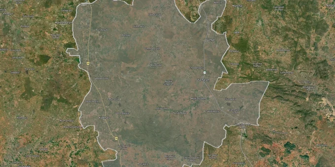
FCDA Masterplan — Bharat Future City Zone, Hyderabad
Future_city Preview
Try the FCDA Masterplan — Bharat Future City Zone, Hyderabad on the map
Sign in once and explore the layer for a full day.
- No card details needed
- Find nearby verified lands for sale
Overview
The Future City Development Authority (FCDA) master plan land Hyderabad layer covers 765.28 sq km spanning 56 revenue villages across seven mandals south of the Outer Ring Road, governed exclusively by the Future City Development Authority (FCDA) established via Telangana Cabinet order in March 2025 for the Bharat Future City project. Of those 56 villages, 36 were transferred from the Hyderabad Metropolitan Development Authority (HMDA) and 20 from the Directorate of Town and Country Planning (DTCP), creating a critical transition period that directly affects which authority's approval stamp is valid on any given plot today. Key infrastructure in this zone includes the Ratan Tata Road (Greenfield Radial Road 1), a 41.5 km expressway connecting the ORR at Raviryal to the RRR at Amangal. This layer is available to premium subscribers on 1acre and overlays FCDA boundary limits on satellite imagery.
Dual Jurisdiction Risk: Why HMDA and DTCP Approvals Issued Before March 2025 Need Reverification in FCDA Limits
FCDA did not begin issuing its own layout and building permissions until late 2025. Before that, despite the gazette notification transferring 56 villages to FCDA jurisdiction, HMDA and DTCP continued issuing layout permissions inside what was legally already FCDA territory. That gap has created a specific category of legal risk: plots carrying HMDA or DTCP approval numbers for layouts within the current FCDA boundary, where the issuing authority was no longer the competent authority at the time of approval.
The table below maps the three approval regimes that exist inside the FCDA zone and the verification action required for each.
Approval Type
Issued By
Period of Validity
Applicable Mandals
Verification Step Required
HMDA Layout Permission (LP) Number
HMDA
Pre-March 2025 (36 transferred villages)
Maheshwaram, Kandukur, Ibrahimpatnam, Yacharam, Manchala, Amangal
Cross-check LP number at hmda.gov.in; confirm village is NOT in transferred list
DTCP Layout Approval
DTCP
Pre-March 2025 (20 transferred villages)
Amangal, Kadthal, outer mandal areas
Verify LP number on DTCP Telangana portal; confirm village transfer status
FCDA Layout Permission
FCDA via BuildNow
Post-December 2025
All 56 villages, 765.28 sq km
Verify via BuildNow platform at buildnow.telangana.gov.in; confirm FCDA routing confirmed
Agricultural / Unclassified
None
Ongoing
Any of the 56 villages, particularly peri-village extents
No layout approval exists; any residential pricing is unsupported without Change of Land Use (CLU) order from FCDA
There is a second and more visible risk in this corridor. The opposition has formally raised the question of whether land previously acquired under the Land Acquisition Act for Hyderabad Pharma City can lawfully be repurposed for Future City, a separate project. That legal dispute has not been resolved. In Yacharam, Kandukur, Kadthal, and Ibrahimpatnam mandals specifically, plots offered as "FCDA-zone residential" may sit on land with competing acquisition claims dating to the Pharma City era, where ~19,333 acres were originally acquired. Ask any seller in those mandals for the exact survey number; check Dharani for encumbrance history; and confirm there is no acquisition notification against that survey number on Bhu Bharati before paying any advance. FCDA Real Estate Regulatory Authority (RERA)-approved plots in active allotment schemes are the safest entry point; private resale in transition-zone villages carries title risk that no FCDA boundary marker removes.
Where FCDA Zone Land Is Moving: Kandukur, Maheshwaram, Kadthal and the Srisailam Highway Corridor
FCDA's 30,000-acre development footprint is concentrated along the Srisailam Highway (NH-765) between the ORR and the Regional Ring Road. Not all 765.28 sq km is equal: land immediately adjacent to the two greenfield radial roads and the proposed AI City and Young India Skill University anchor institutions is in a different demand class from village extents further east toward Amangal.
The table below shows the five micro-market zones within the FCDA layer where zone classification and infrastructure proximity are actively influencing land pricing.
Micro-Market
FCDA Zone Type
Primary Growth Driver
Current Risk Level
Kandukur Mandal (Mirkhanpet)
Mixed use / institutional anchor
FCDA HQ campus (7.5 acres, Survey No. 112); first authority office in field
Low, direct authority presence establishes credibility
Maheshwaram Mandal
Residential, IT, innovation hub
Proximity to ORR, existing plotted market, AI City zone designation
Medium; high demand inflating prices ahead of infrastructure; verify HMDA-to-FCDA approval transition on pre-2025 layouts
Kadthal Mandal
Residential, greenfield
Direct Srisailam Highway FCDA residential zone; DTCP-era approvals transitioning to FCDA
Low to medium; verify approval authority for pre-2025 layouts
Amangal Mandal (Greenfield Road 1 corridor)
Mixed residential and industrial
Ratan Tata Road / Greenfield Radial Road 1 (Raviryal to Amangal, 41.5 km total; Phase 1: 19.2 km Raviryal-Meerkhanpet at Rs 1,665 Cr) connecting ORR to Regional Ring Road (RRR)
Medium: road under construction, not yet operational
Ibrahimpatnam Mandal
Residential
Adjacency to existing IT southeast corridor; farmer resettlement plots from Pharma City acquisition at Meerkhanpet
High active political dispute over resettlement plot registrations in this mandal
Kandukur is the most credible buy in this layer right now and also the most misunderstood. Brokers routinely pitch the whole FCDA zone as "Future City land," flattening the difference between a plot 500 meters from the FCDA headquarters campus at Mirkhanpet and a village extent 25 km further east with no road access. The FCDA headquarters building at Survey No. 112 is the clearest anchor point for authority-led appreciation. Ibrahimpatnam, despite being inside the FCDA zone boundary, carries the highest short-term title risk of any mandal in this layer because resettlement plots from the Pharma City acquisition are actively disputed and some registrations in this area have been flagged by opposition leaders.
Was this layer helpful?
Anything wrong, outdated, or missing we want to hear it.
For Land Owners & Agents
Looking to sell your land in Telangana?
I want to sell my land in Hyderabad HMDA
10:32
Plz share your Land's location - We will list it on 1acre map, for Free.
10:32

For Land Buyers
Browse all verified lands & plots in Telangana
Every listing goes through our Preliminary Verification Process.
More Layers in Telangana
See all 21 layers
Hyderabad HMDA Masterplan: Zone Check and Land Use Guide
View Hyderabad Masterplan as a live map overlay – check any plot's land use zone for free on 1acre.in. Hyderabad masterp...
Warangal Masterplan: WUDA Zone Check and Land Use Guide
View Warangal Masterplan as a live map overlay – check any plot's land use zone for free on 1acre.in. Warangal KUDA mast...
Hyderabad Outer Ring Road (ORR)
View the Hyderabad ORR Growth Corridor on a live map overlay - check HMDA layout approval, zone status and acquisition r...
More Layers in Telangana
Hyderabad HMDA Masterplan: Zone Check and Land Use Guide
View Hyderabad Masterplan as a live map overlay – check any plot's land use zone for free on 1acre.in. Hyderabad masterp...
Warangal Masterplan: WUDA Zone Check and Land Use Guide
View Warangal Masterplan as a live map overlay – check any plot's land use zone for free on 1acre.in. Warangal KUDA mast...
Hyderabad Outer Ring Road (ORR)
View the Hyderabad ORR Growth Corridor on a live map overlay - check HMDA layout approval, zone status and acquisition r...