Karaikal CRZ

Karaikal Crz Preview
Try the Karaikal CRZ on the map
Sign in once and explore the layer for a full day.
- No card details needed
- Find nearby verified lands for sale
Overview
The Karaikal CRZ layer plots the Coastal Regulation Zone footprint along Karaikal's 20 km coastline, the second longest in the U.T. of Puducherry after Pondicherry's 24 km. It mirrors the revised Coastal Zone Management Plan prepared by NCSCM (National Centre for Sustainable Coastal Management) under CRZ Notification 2019 (G.S.R. 37(E)), with the Karaikal region public hearing held on 7 November 2024. The Puducherry Coastal Zone Management Authority (PCZMA) is the regulatory body. This page shows what falls inside CRZ-I, CRZ-II, CRZ-III A, CRZ-III B, and CRZ-IV across Karaikal town, the Arasalar estuary, and the fishing villages. As of May 2026, the Puducherry CZMP under CRZ Notification 2019 has not received confirmed MoEFCC approval despite the November 2024 public hearing. CRZ 2011 rules continue to govern in the interim. Buyers should verify with PCZMA which notification is operative for their specific survey number.
Regulatory Red Flags Inside the No Development Zone
Karaikal sits on the Coromandel Coast, surrounded on three sides by the Cauvery delta districts of Tamil Nadu. Every coastal parcel here gets read against two CZMPs: the older 2011 plan still on PCZMA's map page, and the 2019 plan that went through public hearing in November 2024. Buyers routinely confuse the two, and brokers quote whichever is more favourable.
The fact-pack on what each zone permits in Karaikal, drawn from CRZ Notification 2019 and PCZMA's own SOP for clearance.
Zone Code
Permitted Use
Requires CRZ Clearance?
Prohibited Without?
Commonly Misrepresented?
CRZ-I A
Mangroves, sand dunes, fish breeding areas
No new construction; only utility/strategic
Any building
Sold as "estuary plots"
CRZ-I B
Inter-tidal area between LTL (Low Tide Line) and High Tide Line
Salt works, pipelines only
Houses, resorts
Marketed as "beach plots"
CRZ-II
Built-up Karaikal town municipal area
Yes, on landward side of existing road
Construction on seaward side
Confused with CRZ-III rural
CRZ-III A
Densely populated rural; NDZ 50 m from HTL (High Tide Line)
Beyond NDZ only
Construction inside 50 m
Quoted as "approved layout"
CRZ-III B
Sparse rural; NDZ 200 m from HTL
Beyond NDZ only
Anything inside 200 m
Sold without disclosure
CRZ-IV A
Sea up to 12 nautical miles
Fishing, traditional use
Solid waste, mining
Not applicable to plots
CRZ-IV B
Arasalar estuary and tidal water bodies
Fishing only
Reclamation, dwellings
Sold as "river-facing"
If a seller cannot show your survey number against the approved CZMP map on PCZMA's portal, that plot's CRZ status is unverified. The split between CRZ-III A and CRZ-III B in Karaikal turns on Census 2011 density, and the No Development Zone (NDZ) flips between 50 m and 200 m depending on which side of that threshold the village falls.
Growth Corridors Around Karaikal Beach, Arasalar Estuary and the Port
Karaikal has 12 fishing hamlets and a coastline anchored at three nodes: Karaikal Beach near the river mouth, the Arasalar river estuary north of it, and the deep-water Karaikal port and fishing harbour complex south of the Arasalar mouth. Each carries different CRZ exposure.
The corridors most asked about, mapped against CRZ classification under the 2019 CZMP.
Corridor / Locality
Zone (Karaikal CZMP 2019)
Growth Driver
Known Risk
Karaikal Town core
CRZ-II
French-quarter heritage, municipal
Construction only landward of existing roads
Karaikal Beach front
CRZ-III + CRZ-I B intertidal
Tourism, beach road, boat jetty
NDZ enforced; tourism plan needed
Arasalar estuary (north bank)
CRZ-IV B + CRZ-I A
Boating club, mangroves
Estuary buffer; no private build
Karaikal port / Sanmar terminal
CRZ-II + port limits
Industrial, deep-water harbour
Port operational area classified CRZ-II; new construction requires PCZMA clearance beyond existing authorised port limits.
Fishing harbour (south of Arasalar)
CRZ-III + harbour buffer
World-Bank funded reconstruction
Fish landing centre buffer
Coastal hamlets (12 villages)
CRZ-III A or III B per density
Fishing, semi-rural
Traditional rights; plot subdivision restricted
NH-32 ribbon (inland edge)
CRZ-III B fringe
Connectivity to Chennai-Thoothukudi
Rs 60 crore NH-32 strengthening announced October 2025 — improves connectivity but does not change CRZ classification for fringe parcels. Fringe parcels misquoted as "outside CRZ".
The most misunderstood corridor is the Arasalar estuary stretch. Buyers see the boating club and assume the area is open for resort development. Mangroves and the fish breeding area mark this as CRZ-I A and CRZ-IV B, where private construction is essentially blocked. The "river-facing" plots advertised here usually sit inside the 100 m tidal-water-body buffer or on the 50 m NDZ along the creek, both of which freeze build rights.
Was this layer helpful?
Anything wrong, outdated, or missing we want to hear it.
For Land Owners & Agents
Looking to sell your land in Puducherry?
I want to sell my land in Puducherry
10:32
Plz share your Land's location - We will list it on 1acre map, for Free.
10:32

For Land Buyers
Browse all verified lands & plots in Puducherry
Every listing goes through our Preliminary Verification Process.
More Layers in Puducherry
See all 6 layers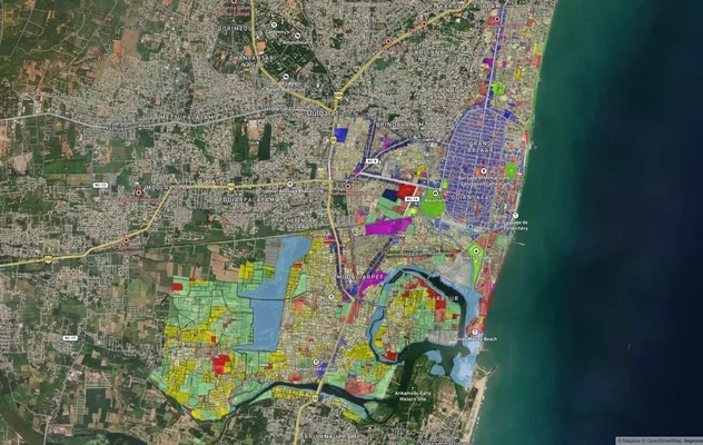
Puducherry Masterplan
View Puducherry Masterplan as a live map overlay – check any plot's land use zone for free on 1acre.in. Puducherry maste...
Mahe CRZ
View Mahe CRZ alignment as a live map overlay – check land acquisition risk and plot proximity free on 1acre.in.

Puducherry CRZ
View Puducherry CRZ alignment as a live map overlay – check land acquisition risk and plot proximity free on 1acre.in.
More Layers in Puducherry
Puducherry Masterplan
View Puducherry Masterplan as a live map overlay – check any plot's land use zone for free on 1acre.in. Puducherry maste...
Mahe CRZ
View Mahe CRZ alignment as a live map overlay – check land acquisition risk and plot proximity free on 1acre.in.
Puducherry CRZ
View Puducherry CRZ alignment as a live map overlay – check land acquisition risk and plot proximity free on 1acre.in.