Puducherry CRZ

Puducherry Crz Preview
Try the Puducherry CRZ on the map
Sign in once and explore the layer for a full day.
- No card details needed
- Find nearby verified lands for sale
Overview
The Puducherry CRZ layer plots the Coastal Regulation Zone footprint along Puducherry region's 24 km coastline on the Bay of Bengal. It mirrors the Coastal Zone Management Plan prepared by NCSCM (National Centre for Sustainable Coastal Management) under CRZ Notification 2019 (G.S.R. 37(E)), with the draft 2019 CZMP under public consultation by PCZMA (Puducherry Coastal Zone Management Authority). The Puducherry Coastal Zone Management Authority (PCZMA) was reconstituted in 2025. Puducherry has 192 km of tidal-influenced water bodies across all four regions and a French-era town surrounded entirely by Tamil Nadu's Villupuram and Kanchipuram districts. This page shows what falls inside CRZ-I, II, III A, III B, and IV across Puducherry town, the Promenade, and the surrounding villages.
Regulatory Red Flags Around the Puducherry Seawall and Lost Promenade Beach
Puducherry has India's most famously broken coastline. The harbour built in 1986 cut sand drift and the Promenade beach vanished within four years. The Government built 6 km of Puducherry seawall harbour erosion protection that pushed erosion further north into Auroville and Tamil Nadu villages. The 2018 NCCR (National Centre for Coastal Research) report flagged 57% of Puducherry's coastline as eroding, the second highest rate in India. Buyers underestimate this when "beachfront" plots get sold along the riprap stretch.
The fact-pack on what each zone permits in Puducherry, drawn from CRZ Notification 2019 and the draft 2019 CZMP.
Zone Code
Permitted Use
Requires CRZ Clearance?
Prohibited Without?
Commonly Misrepresented?
CRZ-I A
Mangroves (Thengaithittu), sand dunes, mudflats, salt marshes, turtle nesting
No new construction; only utility
Any building
Sold as "private beach plots"
CRZ-I B
Inter-tidal between LTL (Low Tide Line) and High Tide Line
Salt works, pipelines only
Houses, resorts
Marketed as "Promenade-side"
CRZ-II
Built-up Puducherry municipal area, French Quarter
Yes, on landward side of existing road
Construction on seaward side
Confused with CRZ-III rural
CRZ-III A
Densely populated rural; NDZ 50 m from HTL
Beyond NDZ only
Construction inside 50 m
Quoted as "DTCP approved"
CRZ-III B
Sparse rural; NDZ 200 m from HTL
Beyond NDZ only
Anything inside 200 m
Sold without ESA cross-check
CRZ-IV A/B
Sea up to 12 nautical miles + Ariyankuppam estuary
Fishing only
Reclamation, dwellings
Sold as "river-facing"
The local enforcement gap is real. NCSCM mapped only 82.64 acres of mangroves in Puducherry and Karaikal, but CPRM's 2024 study identified an additional 228 acres of mangroves and 355.19 acres of sand dunes missing from the draft 2019 CZMP. If a parcel sits on stretches that environmentalists have flagged as unmapped ESAs, expect that classification to tighten before the final notified plan, not loosen.
Growth Corridors Along the Promenade, Ariyankuppam and the French Quarter
Puducherry property splits into two distinct markets. The French Quarter and Tamil Quarter inside Puducherry Municipality are CRZ-II urban with FSI freeze rules under the 2019 notification. Outside the town, the Promenade Ariyankuppam Thengaithittu belt and the rural villages running south to the Tamil Nadu border are CRZ-III mix. The Tamil Nadu border surrounds the entire enclave, so cross-border parcels need TNSCZMA jurisdiction, not PCZMA clearance.
The corridors most asked about, mapped against CRZ classification under the draft 2019 CZMP.
Corridor / Locality
Zone (Puducherry CZMP 2019)
Growth Driver
Known Risk
Promenade (Goubert Avenue)
CRZ-II + CRZ-IV B (artificial reef)
Heritage, tourism, beach restoration
Construction only landward of existing roads
French Quarter (White Town)
CRZ-II
UNESCO heritage push, boutique hotels
FSI as per 1991 levels; redevelopment limited
Tamil Quarter (Black Town)
CRZ-II
Commercial core
Built-up over 50%; CRZ-II rules apply
Ariyankuppam estuary
CRZ-IV B + CRZ-I A
Harbour, fishing
Estuary buffer; private builds blocked
Thengaithittu mangroves
CRZ-I A (afforested 1990s)
Mangrove conservation
Blanket restriction on construction
Auroville coastal villages (north)
CRZ-III A and III B mix
Coastal community, Auroville housing
Severe erosion north of harbour; geo-tube zones
Karikalampakkam, Murungapakkam
CRZ-III B
Residential expansion
NDZ 200 m; 2011 Census drives classification
The most misunderstood corridor is the Auroville stretch immediately north of the Puducherry harbour. The 1986 harbour and breakwaters caused continuous erosion at Chinna Mudaliyar Chavady and Quiet Healing Centre. The Tamil Nadu PWD built groynes and a seawall in 2013 at Chinnamudaliarchavadi, but the construction was halted after 400 m. Plots advertised as "Auroville-adjacent beachfront" usually sit inside this active erosion belt, where the shoreline retreated by an estimated 40 m by 2014.
Was this layer helpful?
Anything wrong, outdated, or missing we want to hear it.
For Land Owners & Agents
Looking to sell your land in Puducherry?
I want to sell my land in Puducherry
10:32
Plz share your Land's location - We will list it on 1acre map, for Free.
10:32

For Land Buyers
Browse all verified lands & plots in Puducherry
Every listing goes through our Preliminary Verification Process.
More Layers in Puducherry
See all 6 layers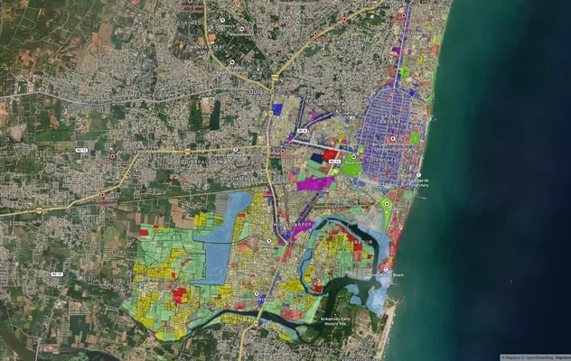
Puducherry Masterplan
View Puducherry Masterplan as a live map overlay – check any plot's land use zone for free on 1acre.in. Puducherry maste...

Karaikal CRZ
View Karaikal CRZ alignment as a live map overlay – check land acquisition risk and plot proximity free on 1acre.in.
Mahe CRZ
View Mahe CRZ alignment as a live map overlay – check land acquisition risk and plot proximity free on 1acre.in.
More Layers in Puducherry
Puducherry Masterplan
View Puducherry Masterplan as a live map overlay – check any plot's land use zone for free on 1acre.in. Puducherry maste...
Karaikal CRZ
View Karaikal CRZ alignment as a live map overlay – check land acquisition risk and plot proximity free on 1acre.in.
Mahe CRZ
View Mahe CRZ alignment as a live map overlay – check land acquisition risk and plot proximity free on 1acre.in.