Yanam CRZ
Yanam Crz Preview
Try the Yanam CRZ on the map
Sign in once and explore the layer for a full day.
- No card details needed
- Find nearby verified lands for sale
Overview
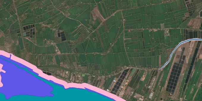
The Yanam CRZ layer plots the Coastal Regulation Zone footprint across the 30 sq km enclave of Puducherry on the Godavari delta, surrounded entirely by Andhra Pradesh's East Godavari district. Yanam has no direct sea coast; the entire CRZ here runs along the Gauthami-Godavari river and the Coringa channel that branch off at Yanam itself. The layer mirrors the Coastal Zone Management Plan prepared by PCZMA under CRZ Notification 2019 (G.S.R. 37(E)), with public hearing held on 12 April 2023. This page shows what falls inside CRZ-I, II, III A, III B, and IV across Yanam town and the six villages.
Regulatory Red Flags Around the Coringa CVCA
Yanam is bounded on the east and south by the Gauthami-Godavari river, which discharges into the Bay of Bengal 14 km east of the town. The river is tidal up to 45 km from the mouth (per NCSCM CRZ survey data), which puts the entire enclave within the CRZ zone via tidal-water-body classification. The Coringa CVCA mangroves, India's second largest mangrove stretch covering 320 sq km, sits immediately south. CRZ Notification 2019 lists Coringa as a Critical Vulnerable Coastal Area, requiring management with fisher community involvement.
The fact-pack on what each zone permits in Yanam, drawn from CRZ Notification 2019 and the PCZMA SOP.
Zone Code
Permitted Use
Requires CRZ Clearance?
Prohibited Without?
Commonly Misrepresented?
CRZ-I A
Coringa CVCA mangroves, mudflats, tidal creeks
No new construction; only utility
Any building
Sold as "river-mouth plots"
CRZ-I B
Inter-tidal area along the Gauthami-Godavari
Salt works, pipelines only
Houses, resorts
Marketed as "ferry-side plots"
CRZ-II
Built-up Yanam municipal urban area
Yes, on landward side of existing road
Construction on seaward side
Confused with CRZ-III rural
CRZ-III A
Densely populated rural; NDZ 50 m from HTL
Beyond NDZ only
Construction inside 50 m
Quoted without 2011 census check
CRZ-III B
Sparse rural; NDZ 200 m from HTL
Beyond NDZ only
Anything inside 200 m
Sold without disclosure
CRZ-IV B
Gauthami-Godavari tidal stretch up to 5 ppt salinity
Fishing only
Reclamation, dwellings
Sold as "river-facing villa plots"
The No Development Zone (NDZ) along the Gauthami-Godavari river in CRZ-III is 50 metres from HTL or river width, whichever is less. If a seller in Yanam quotes only the 500 m sea CRZ rule, they are reading the wrong section. Yanam has no direct seafront; the entire CRZ here is driven by tidal water body rules under the 2019 notification, and the Coringa CVCA listing strengthens the case for refusing any clearance near the southern boundary.
Growth Corridors Across Yanam Town and the Six Villages
Yanam region is one municipality covering Yanam municipality six villages plus the town. The town sits on the spot where the Coringa river branches off from the Gauthami-Godavari. Property activity concentrates on the river-front ferry road, the walkway corridor, and the villages bordering the East Godavari district. The Puducherry Coastal Zone Management Authority treats the entire 30 sq km enclave as one CZMP zone, but the river side and the village interiors carry very different CRZ exposure.
The corridors most asked about, mapped against CRZ classification under the 2019 CZMP.
Corridor / Locality
Zone (Yanam CZMP 2019)
Growth Driver
Known Risk
Yanam town riverfront
CRZ-II + CRZ-IV B
French heritage, Rajiv Park, walkway
Construction only landward of existing roads
Ferry Road / Yedurlanka Bridge
CRZ-II + CRZ-I A pockets
Tourism, photoshoot zones
River buffer + intertidal restriction
Yanam mangrove forest (south)
CRZ-I A (Coringa CVCA range)
Boating, eco-tourism
Blanket restriction; private builds blocked
Six villages interior
CRZ-III A or III B per Census 2011
Residential, semi-rural
NDZ varies; verify per survey number
AP-border ribbon (Kakinada, Konaseema side)
Falls outside Puducherry CRZ
Rajahmundry-Kakinada corridor
Cross-border parcels need APCZMA, not PCZMA
Gauthami-Godavari river bank
CRZ-IV B + CRZ-I A
Walkway, water sports
50 m river NDZ stacks on tidal classification
The most misunderstood corridor is the southern village belt facing the Coringa channel. Buyers see open land and assume agricultural plots are unlocked. Coringa is a CVCA listed in CRZ Notification 2019 itself, with mangrove and mudflat stretches classified as CRZ-I A. The Coringa range extends into the Yanam administrative area, and PCZMA treats clearance applications in this belt with explicit CVCA-specific scrutiny.
Was this layer helpful?
Anything wrong, outdated, or missing we want to hear it.
For Land Owners & Agents
Looking to sell your land in Puducherry?
I want to sell my land in Puducherry
10:32
Plz share your Land's location - We will list it on 1acre map, for Free.
10:32

For Land Buyers
Browse all verified lands & plots in Puducherry
Every listing goes through our Preliminary Verification Process.
More Layers in Puducherry
See all 6 layers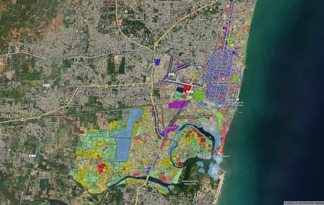
Puducherry Masterplan
View Puducherry Masterplan as a live map overlay – check any plot's land use zone for free on 1acre.in. Puducherry maste...

Karaikal CRZ
View Karaikal CRZ alignment as a live map overlay – check land acquisition risk and plot proximity free on 1acre.in.
Mahe CRZ
View Mahe CRZ alignment as a live map overlay – check land acquisition risk and plot proximity free on 1acre.in.
More Layers in Puducherry
Puducherry Masterplan
View Puducherry Masterplan as a live map overlay – check any plot's land use zone for free on 1acre.in. Puducherry maste...
Karaikal CRZ
View Karaikal CRZ alignment as a live map overlay – check land acquisition risk and plot proximity free on 1acre.in.
Mahe CRZ
View Mahe CRZ alignment as a live map overlay – check land acquisition risk and plot proximity free on 1acre.in.