Mahe CRZ
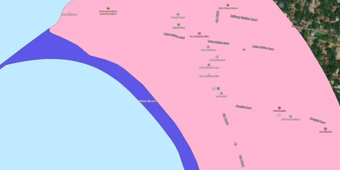
Mahe Crz Preview
Try the Mahe CRZ on the map
Sign in once and explore the layer for a full day.
- No card details needed
- Find nearby verified lands for sale
Overview
The Mahe CRZ layer plots the Coastal Regulation Zone footprint across the smallest district in India by land area, just 8.69 sq km, with only 1 km of seafront on the Arabian Sea. It mirrors the Coastal Zone Management Plan prepared for Mahe by the Puducherry Coastal Zone Management Authority (PCZMA) under CRZ Notification 2019 (G.S.R. 37(E)). Mahe is part of Puducherry U.T. but surrounded on three sides by Kannur district and on one side by Kozhikode district of Kerala. This page shows what falls inside CRZ-I, II, III A, III B, and IV across Mahe town and the four Naluthara villages.
Regulatory Red Flags Around the Mayyazhi River Estuary
Mahe is a regulatory anomaly. The land is governed by Puducherry under CRZ Notification 2019 and PCZMA, but the Mayyazhi river estuary that defines its northern boundary flows from Wayanad through Kerala before reaching the sea at Mahe. The CZMP map for Puducherry-Mahe is separate from the Kerala CZMP for Kannur and Kozhikode, but the river course is documented in both, and lawyers routinely confuse which authority's clearance applies to a given parcel.
The fact-pack on what each zone permits in Mahe, drawn from CRZ Notification 2019 and the PCZMA SOP.
Zone Code
Permitted Use
Requires CRZ Clearance?
Prohibited Without?
Commonly Misrepresented?
CRZ-I A
Sand dunes, mangroves, ecologically sensitive features
No new construction; only utility/strategic
Any building
Sold as "river-mouth plots"
CRZ-I B
Inter-tidal between LTL and High Tide Line
Salt works, pipelines only
Houses, resorts
Marketed as "beachfront"
CRZ-II
Built-up Mahe municipal urban area
Yes, on landward side of existing road
Construction on seaward side
Confused with CRZ-III rural
CRZ-III A
Densely populated; NDZ 50 m from HTL
Beyond NDZ only
Construction inside 50 m
Quoted as "DTCP approved"
CRZ-III B
Sparse rural; NDZ 200 m from HTL
Beyond NDZ only
Anything inside 200 m
Sold without CZMP cross-check
CRZ-IV A
Sea up to 12 nautical miles
Fishing, traditional use
Solid waste, mining
Not applicable to plots
CRZ-IV B
Mahe river tidal stretch and estuary
Fishing only
Reclamation, dwellings
Sold as "river-facing villa plots"
Given Mahe's tiny 9 sq km footprint, almost every parcel sits within either the 500 m sea CRZ or the 50 m No Development Zone (NDZ) along the tidal river. If a seller cannot show the survey number against PCZMA's approved Mahe CZMP map, that plot's CRZ status is unverified, and a Kannur or Kozhikode broker who quotes the Kerala CZMP is reading the wrong document.
Growth Corridors Across Mahe Town and the Naluthara Villages
Mahe is administratively one municipality with two parts: Mahe town and Naluthara villages. Naluthara comprises Pandakkal, Pallur, Chalakara, and Chembra. The seafront sits on the Mahe town side. The river bank stretches across both. The Puducherry Coastal Zone Management Authority treats the entire enclave as one CZMP zone, but classification within the 8.69 sq km area varies sharply by village density and proximity to the Mayyazhi river.
The corridors most asked about, mapped against CRZ classification under the 2019 CZMP.
Corridor / Locality
Zone (Mahe CZMP 2019)
Growth Driver
Known Risk
Mahe town seafront
CRZ-II + CRZ-I B intertidal
French heritage, St. Teresa's Church
Construction only landward of existing roads
Mahe river mouth (Azhimukham)
CRZ-IV B + CRZ-I A
Walkway, water sports complex
Estuary buffer; private build blocked
Pandakkal
CRZ-III A by density
NRI-driven plot demand
NDZ enforced from river bank
Pallur
CRZ-III A or III B per Census
Residential, semi-rural
50 m or 200 m NDZ depending on density
Chalakara
CRZ-III B largely
Quiet residential pockets
200 m setback freezes large parcels
Chembra
CRZ-III mix
Connectivity to Thalassery
Mixed CRZ-II and III; verify per survey number
Mahe-Thalassery border ribbon
CRZ-III fringe
Kannur Airport corridor demand
Fringe parcels misquoted as "outside CRZ"
The most misunderstood corridor is the river-bank stretch. Buyers see the Mayyazhi promenade and assume the entire river frontage is CRZ-II urban. CRZ Notification 2019 places a 50 m NDZ along tidal water bodies in CRZ-III, plus the river mouth and adjacent mangrove patches as CRZ-I A. River-facing parcels in Pandakkal or Pallur usually sit inside this band, regardless of the panchayat classification.
Was this layer helpful?
Anything wrong, outdated, or missing we want to hear it.
For Land Owners & Agents
Looking to sell your land in Puducherry?
I want to sell my land in Puducherry
10:32
Plz share your Land's location - We will list it on 1acre map, for Free.
10:32

For Land Buyers
Browse all verified lands & plots in Puducherry
Every listing goes through our Preliminary Verification Process.
More Layers in Puducherry
See all 6 layers
Puducherry Masterplan
View Puducherry Masterplan as a live map overlay – check any plot's land use zone for free on 1acre.in. Puducherry maste...

Karaikal CRZ
View Karaikal CRZ alignment as a live map overlay – check land acquisition risk and plot proximity free on 1acre.in.

Puducherry CRZ
View Puducherry CRZ alignment as a live map overlay – check land acquisition risk and plot proximity free on 1acre.in.
More Layers in Puducherry
Puducherry Masterplan
View Puducherry Masterplan as a live map overlay – check any plot's land use zone for free on 1acre.in. Puducherry maste...
Karaikal CRZ
View Karaikal CRZ alignment as a live map overlay – check land acquisition risk and plot proximity free on 1acre.in.
Puducherry CRZ
View Puducherry CRZ alignment as a live map overlay – check land acquisition risk and plot proximity free on 1acre.in.