Puducherry Masterplan
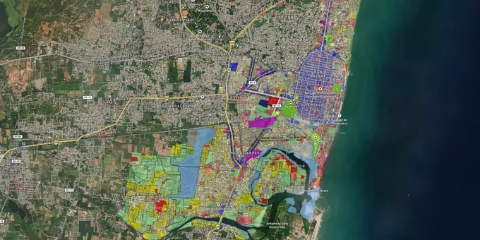
Puducherry Masterplan Preview
Try the Puducherry Masterplan on the map
Sign in once and explore the layer for a full day.
- No card details needed
- Find nearby verified lands for sale
Overview
The Puducherry masterplan land zone for every plot in the region is determined by the Comprehensive Development Plan for Puducherry Planning Area 2036 (PPA CDP 2036). Approved vide G.O. Ms. No. 21/2019-Hg on 31 October 2019 and published in Extraordinary Gazette Part-I No. 202, the plan is administered by the Puducherry Planning Authority (PPA) under the Puducherry Town and Country Planning Act, 1969. It governs Puducherry Municipality, Oulgaret Municipality, and five commune panchayats: Villianur, Ariankuppam, Nettapakkam, Bahour, and Mannadipet. This page covers the zone classifications, regulatory traps, and active growth corridors you need to evaluate before committing to any land purchase.
Unapproved Layouts and the CDP Boundary Trap That Catches Puducherry Buyers
The most expensive mistake buyers make in Puducherry is assuming that a registered sale deed equals a legally buildable plot. It does not.
A large share of the city's residential growth happened outside the formal PPA approval system. The Puducherry One-Time Regularization Scheme for Unpermitted Constructions and Deviations 2025, notified on 16 July 2025, is direct evidence of how widespread the problem is. The scheme offers a path to legalize unauthorized constructions built between 1 May 1987 and 16 July 2025. It explicitly excludes three categories: plots lacking clear land title, encroachments on government land, and constructions that cannot be regularised under applicable planning and safety norms. If your target plot falls into any of those three, no regularization route exists.
The second trap is the CDP boundary itself. PPA CDP 2036 applies full development controls to Puducherry Municipality and Oulgaret Municipality. For the five commune panchayats, the PPA issues building permits only in existing settlements or developed areas. Brokers regularly present commune panchayat land as "CDP-approved." It is not. Any non-agricultural use on commune panchayat land outside an existing settlement requires a Land Use Conversion (LUC) recommendation from the designated committee before any construction can begin.
The third risk is specific to the core city: the Boulevard Area (White Town) sits under a Heritage Conservation overlay in the CDP 2036. The State Level Heritage Conservation and Advisory Committee (SLHCAC) maintains an active list of notified heritage buildings in the Boulevard. Height restrictions and facade controls that apply to these properties are almost never disclosed at the point of sale.
The table below maps the three main zone contexts in the Puducherry CDP 2036 and what each one means for a buyer.
Zone Context
Permit Regime
Critical Risk
Puducherry and Oulgaret Municipalities (within CDP)
Full PPA building permit required
Unapproved layouts on earmarked land cannot be regularized
Commune Panchayats: Villianur, Ariankuppam, Nettapakkam, Bahour, Mannadipet
Permit only in existing settlements; LUC needed for non-agricultural use
Frequently marketed as CDP-compliant by brokers
Boulevard Area (Heritage Conservation overlay)
CDP 2036 Conservation Zone + SLHCAC heritage register
Height and renovation restrictions not visible in sale documents
The Puducherry Building Bye-Laws and Zoning Regulations 2012, most recently amended in September 2025 (G.O. Ms.No.16/2025-Hg), govern all construction inside the planning area. If a seller cannot produce a PPA layout approval or building permit for an existing structure on the plot, that is a reason to walk away.
Oulgaret, Villianur, and the Commune Panchayat Growth Corridors Worth Watching
The PPA CDP 2036 structures growth around three spatial strategies: the Boulevard Conservation Zone (heritage core), the Conurbation Densification Zone covering Puducherry and Oulgaret municipalities, and three designated growth centres at Madagadipet, Nettapakkam, and Bahour. PPA invited expressions of interest for Detailed Development Plans (DDPs) for these growth centres in 2021, but those DDPs have not yet been notified.
Oulgaret Municipality is the city's most active residential corridor. It absorbs demand displaced from the congested Boulevard core and carries full CDP permit coverage, making it the safer bet for buyers who need regulatory clarity now. The ECR (East Coast Road) corridor running through Villianur commune connects Puducherry to Chennai and Cuddalore and anchors significant institutional demand: Aarupadai Veedu Medical College and Vinayaka Mission's Research Foundation sit along this stretch. That institutional pull creates residential demand, but Villianur remains a commune panchayat, meaning the land use conversion requirement applies.
The table below sets out each corridor and its current zone status under the PPA CDP 2036.
Corridor / Locality
Zone Context (CDP 2036)
Growth Driver
Known Risk
Oulgaret Municipality
Conurbation Densification Zone
Core urban residential expansion
Unapproved layouts, ongoing Change of Land Use (CLU) requests
Villianur Commune (ECR stretch)
Outside CDP; existing settlements only
ECR connectivity, medical institutions
Non-agricultural LUC required
Nettapakkam Commune
Designated Growth Centre (DDP pending)
PPA-designated expansion zone
DDP not notified; full CDP controls not yet operative
Bahour Commune
Designated Growth Centre (DDP pending)
PPA-designated expansion zone
DDP not notified; commune panchayat rules apply
Mannadipet Commune
Outside CDP; existing settlements only
Peripheral residential
LUC required; minimal infrastructure
Nettapakkam is the most misread corridor. Buyers see the PPA's "growth centre" designation and assume the same permit clarity as Oulgaret. They are wrong. Until PPA notifies the Nettapakkam Detailed Development Plan (DDP), the commune panchayat building permit rules govern every transaction there.
Was this layer helpful?
Anything wrong, outdated, or missing we want to hear it.
For Land Owners & Agents
Looking to sell your land in Puducherry?
I want to sell my land in Puducherry
10:32
Plz share your Land's location - We will list it on 1acre map, for Free.
10:32

For Land Buyers
Browse all verified lands & plots in Puducherry
Every listing goes through our Preliminary Verification Process.
More Layers in Puducherry
See all 6 layers
Puducherry CRZ
View Puducherry CRZ alignment as a live map overlay – check land acquisition risk and plot proximity free on 1acre.in.

Karaikal CRZ
View Karaikal CRZ alignment as a live map overlay – check land acquisition risk and plot proximity free on 1acre.in.
Mahe CRZ
View Mahe CRZ alignment as a live map overlay – check land acquisition risk and plot proximity free on 1acre.in.
More Layers in Puducherry
Puducherry CRZ
View Puducherry CRZ alignment as a live map overlay – check land acquisition risk and plot proximity free on 1acre.in.
Karaikal CRZ
View Karaikal CRZ alignment as a live map overlay – check land acquisition risk and plot proximity free on 1acre.in.
Mahe CRZ
View Mahe CRZ alignment as a live map overlay – check land acquisition risk and plot proximity free on 1acre.in.