Panchkula Extension 2 (Alipur) Masterplan
Overview
The Panchkula Extension 2 masterplan zone covers the Alipur area along NH-73 (Chandigarh-Yamunanagar highway), governed by the Draft Development Plan 2021 prepared by the Town and Country Planning Department (TCP), Haryana. The plan spans 24 proposed sectors, is designed for approximately 2,73,700 residents, and integrates residential, industrial, commercial, and green-belt land uses. This layer on 1acre, available to Premium subscribers, maps the exact zone classification for each survey number in this area, so you can verify land use before you sign anything.
NH-73 Corridor: Where the Real Opportunity Is and Where It Is Not
Extension 2 sits at the intersection of two genuinely strong tailwinds: spillover demand from prime Panchkula sectors (where one-kanal plots now fetch ₹14–20 crore) and HSIIDC's 600-acre pollution-free industrial presence in Sectors 10 and 13, which creates sustained employment demand for nearby residential land. Plots across the NH-73 corridor are currently priced between ₹50,000 and ₹1 lakh per square yard, a fraction of established Panchkula sector rates above ₹2 lakh per square yard.
The table below maps the key sub-zones by risk profile.
Sector / Locality
Primary Land Use (Draft Plan 2021)
Growth Driver
Known Risk
Sectors 10, 13 (Alipur)
Industrial (Haryana State Industrial and Infrastructure Development Corporation (HSIIDC))
Established industry, IT Park
No residential construction permitted
Sectors 12, 14 (Barwala highway)
Residential
NH-73 access, Shivalik views, RERA projects active
Unauthorised layouts active in same zone
Barwala village belt
Agricultural / Transition
Proximity to model town plan
Highest incidence of unlicensed colonies
Sectors 15, 16
Emerging residential
32m sector roads proposed, link road to Mohali planned
Infrastructure timeline uncertain
The most misread corridor is Barwala village itself. Brokers sell plots here at Extension 2 prices, but much of this land has not received CLU and sits outside licensed colony boundaries. Check the HRERA portal before any booking, not after.
Was this layer helpful?
Anything wrong, outdated, or missing we want to hear it.
For Land Owners & Agents
Looking to sell your land in Haryana?
I want to sell my land in Haryana
10:32
Plz share your Land's location - We will list it on 1acre map, for Free.
10:32

For Land Buyers
Browse all verified lands & plots in Haryana
Every listing goes through our Preliminary Verification Process.
More Layers in Haryana
See all 14 layers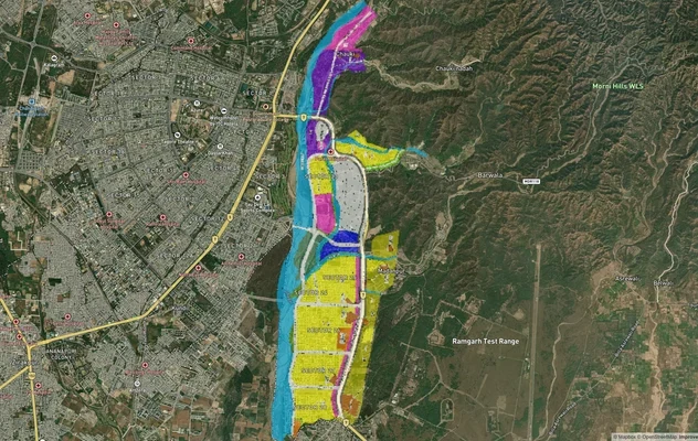
Panchkula Extension 1 Masterplan
View Panchkula Extension 1 Masterplan as a live map overlay – check any plot's land use zone for free on 1acre.in. Panch...
Panchkula Masterplan
View Panchkula Masterplan as a live map overlay – check any plot's land use zone for free on 1acre.in. Panchkula Master ...
Hodal Masterplan 2031: DTCP Zone Check and Land Use Guide
View Hodal Masterplan as a live map overlay – check any plot's land use zone for free on 1acre.in. Hodal Masterplan 2031...
More Layers in Haryana
Panchkula Extension 1 Masterplan
View Panchkula Extension 1 Masterplan as a live map overlay – check any plot's land use zone for free on 1acre.in. Panch...
Panchkula Masterplan
View Panchkula Masterplan as a live map overlay – check any plot's land use zone for free on 1acre.in. Panchkula Master ...
Hodal Masterplan 2031: DTCP Zone Check and Land Use Guide
View Hodal Masterplan as a live map overlay – check any plot's land use zone for free on 1acre.in. Hodal Masterplan 2031...