Pinjore - Kalka Masterplan
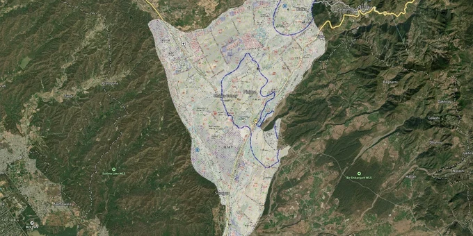
Pinjore Kalka Masterplan Preview
Try the Pinjore - Kalka Masterplan on the map
Sign in once and explore the layer for a full day.
- No card details needed
- Find nearby verified lands for sale
Overview
The Pinjore Kalka Urban Complex Master Plan 2031 (PKUC 2031), prepared by Haryana's Town and Country Planning Department, covers a total urbanisable area of 3,811.73 hectares across Pinjore and Kalka towns in Panchkula district. Both towns sit within the Punjab New Capital Periphery Controlled Area, declared in 1972, which means any land purchase here falls under an additional layer of state regulation that most brokers never explain upfront. This layer on 1acre requires a Premium subscription. This page covers zone classifications, Change of Land Use (CLU) rules, the Supreme Court land acquisition freeze, and the corridors where the plan concentrates future industrial and residential growth.
Illegal Layouts and the HUDA Acquisition Freeze: The Regulatory Risk Pinjore Buyers Routinely Ignore
Here is the fact most brokers selling Pinjore Kalka Urban Complex plots skip entirely. In 2012, the Supreme Court of India held that HUDA's acquisition of over 809 acres in the Pinjore Kalka Urban Complex was "prima facie illegal", land had been acquired under the guise of public purpose but effectively benefited private builders. In April 2012 the Supreme Court initially held the acquisition prima facie illegal and temporarily halted construction. By December 2012 the court dismissed all challenges, vacated the stay, and cleared HUDA's acquisition to proceed. Buying land on any parcel that traces its title back to that 2007 acquisition without verifying the current status of that Supreme Court direction is a serious risk that title insurance will not cover.
Separately, the entire Pinjore Kalka area is a Periphery Controlled Area under the Punjab New Capital (Periphery) Control Act, 1952. Any change of land use requires a CLU permission from the Director, Town and Country Planning, Haryana. This is not a formality, without a valid CLU, a plot sold to you as "residential" or "commercial" may legally remain agricultural. Haryana's Town and Country Planning (TCP) rules do not allow industrial units in the agriculture zone of Hyper or High Potential Zones; non-polluting SSI units under 2 acres are the narrow exception.
The table below lists the zone categories proposed in the PKUC 2031 plan and their share of total planning area.
Zone
Allocated Area (Hectares)
Share of Total Plan Area
CLU Required to Change Use?
Residential
1,100.28
28.86%
Yes
Commercial
243.46
6.38%
Yes
Industrial
598.78
15.70%
Yes
Transportation
434.41
11.40%
N/A
Open Space
1,295.59
33.98%
Not permissible
Public/Semi-Public
83.19
2.18%
Yes
Public Utilities
56.68
1.50%
N/A
Before you pay any token amount, ask for the survey number of the plot and cross-check the zone against the PKUC 2031 plan map at tcpharyana.gov.in. If the broker cannot show you the zone classification for that specific survey number, do not proceed.
NH-21A Industrial Corridor and Sector 30 Pinjore: Where the Plan Concentrates Growth
The PKUC 2031 plan is direct about where it expects Pinjore Kalka's economic future to come from. Except for the existing HMT facility, neither town had significant industrial activity at the time the plan was drafted. The plan addresses this by reserving 598.78 hectares specifically for industrial use along the Pinjore Nalagarh Road (NH-21A). The rationale is explicit: Panchkula's industrial area is already exhausted, Pinjore is positioned as the next industrial base, and the plan expects it to serve as an ancillary hub for the 2,500+ companies in the Baddi Barotiwala Nalagarh belt located approximately 10 km away.
Only non-polluting industries are permitted in the proposed Phase II industrial area along NH-21A. The 36-km Pinjore–Nalagarh four-lane project was launched in April 2022, slated for completion by September 2024. As of early 2026, large portions remain unfinished, with expenditure exceeding Rs 774.78 crore against a revised budget of Rs 670 crore, which will directly improve freight movement on this corridor.
The table below maps the key corridors against their plan designation and investment logic.
Corridor / Locality
PKUC 2031 Zone
Growth Driver
Known Risk
Pinjore Nalagarh Road (NH-21A)
Industrial Phase II
Ancillary to Baddi-Barotiwala belt; non-polluting only
CLU mandatory; polluting industry not permitted
Sector 30 Pinjore
Residential
HUDA sector; developed node within plan boundary
Verify title chain for pre-2007 acquisitions
NH-5 (Ambala-Shimla corridor)
Mixed / Transportation
Gateway corridor; thickly built up
Limited expansion scope; bypass proposed
Civil Aviation Club area (NH-21A)
Transport Communication
40.48 hectares reserved; adjacent to industrial zone
No residential use permissible in this buffer
Kalka town centre
Commercial/Residential
Railway terminus; historic built-up area
Congestion limits further densification
The most misread corridor is the Civil Aviation Club buffer along NH-21A. Plots adjacent to this 40-hectare reserved transport zone regularly get marketed as "industrial-facing" land. They may be, but the reservation itself is off-limits for construction and the buffer setbacks reduce usable area on neighbouring parcels.
Was this layer helpful?
Anything wrong, outdated, or missing we want to hear it.
For Land Owners & Agents
Looking to sell your land in Haryana?
I want to sell my land in Haryana
10:32
Plz share your Land's location - We will list it on 1acre map, for Free.
10:32

For Land Buyers
Browse all verified lands & plots in Haryana
Every listing goes through our Preliminary Verification Process.
More Layers in Haryana
See all 14 layers
Hodal Masterplan 2031: DTCP Zone Check and Land Use Guide
View Hodal Masterplan as a live map overlay – check any plot's land use zone for free on 1acre.in. Hodal Masterplan 2031...

Kot - Behla Masterplan
View Kot - Behla Masterplan as a live map overlay – check any plot's land use zone for free on 1acre.in. Panchkula Kot B...
Mansa Devi Complex (MDC) Panchkula: HSVP Zone Check and Plot Guide
View Mansa Devi Complex Masterplan as a live map overlay – check any plot's land use zone for free on 1acre.in. Mansa De...
More Layers in Haryana
Hodal Masterplan 2031: DTCP Zone Check and Land Use Guide
View Hodal Masterplan as a live map overlay – check any plot's land use zone for free on 1acre.in. Hodal Masterplan 2031...
Kot - Behla Masterplan
View Kot - Behla Masterplan as a live map overlay – check any plot's land use zone for free on 1acre.in. Panchkula Kot B...
Mansa Devi Complex (MDC) Panchkula: HSVP Zone Check and Plot Guide
View Mansa Devi Complex Masterplan as a live map overlay – check any plot's land use zone for free on 1acre.in. Mansa De...