
Trans-Haryana Expressway - NH-152D


Trans Haryana Expressway Nh 152d Preview
Try the Trans-Haryana Expressway - NH-152D on the map
Sign in once and explore the layer for a full day.
- No card details needed
- Find nearby verified lands for sale
Overview
NH-152D, the Trans-Haryana Expressway, is a 227 km, six-lane, access-controlled greenfield expressway from Gangheri near Ismailabad in Kurukshetra district, where it meets NH-152, to the Narnaul bypass on NH-148B in Mahendragarh district. It opened to traffic on 1 August 2022 at a total cost of Rs 5,108 crore. The right of way is 70 metres wide, with 122 bridges and underpasses and over 1,36,000 trees along the alignment. It passes through eight districts: Kurukshetra, Kaithal, Karnal, Jind, Rohtak, Bhiwani, Charkhi Dadri and Mahendragarh, and about 112 villages, with 16 interchanges and two main toll plazas. The expressway forms part of the wider Ambala-Kotputli Economic Corridor. For Trans Haryana Expressway land buying, the route comes first: a plot's value depends on its road distance from an interchange, not on how close it looks to the carriageway. This page covers the NH-152D route map and towns, its length and distances, the Rohtak and Narnaul stretches, the zone rules, the document checks that matter, and the corridors where appreciation is real versus speculative.
NH-152D route map and towns on the route
Searches for the 152D highway route map want three things: where the road runs, which towns it serves and where you can get on and off. From north to south, the main interchanges and the roads they connect are:
NH-152D route map and towns on the route
Interchange area
District
Connects to
Gangheri, near Ismailabad (start)
Kurukshetra
NH-152 (Ambala to Pehowa)
East of Pehowa
Kurukshetra
SH-6 (Pehowa, Kurukshetra, Yamunanagar)
Dhand, near Kaul
Kaithal
SH-9 (Pehowa to Karnal)
East of Pundri
Kaithal
SH-8 (Kaithal to Karnal)
Badhana-Popran, north-east of Jind
Jind
SH-12 (Jind, Assandh, Karnal)
Near Pilu Khera
Jind
Delhi-Amritsar-Katra Expressway; SH-14 (Jind to Panipat) at Jamni
East of Jind
Jind
SH-11 (Jind, Gohana, Sonipat)
Kila Zafargarh, south of Julana
Jind
NH-352 (Jind, Julana, Lakhan Majra, Rohtak)
Kharkara and Kalanaur
Rohtak
NH-9; NH-709 (Bhiwani to Rohtak)
East of Charkhi Dadri
Charkhi Dadri
NH-334B (Loharu, Charkhi Dadri, Jhajjar)
Buchawas, east of Mahendragarh
Mahendragarh
SH-24 (Mahendragarh, Kanina, Rewari)
Narnaul bypass (end)
Mahendragarh
NH-148B (Narnaul to Kotputli)
Towns that appear in searches, such as Pehowa, Kaul, Pundri, Julana, Kalanaur, Charkhi Dadri, Kanina and Narnaul, are reached through these interchanges rather than from the carriageway. Two-wheelers, three-wheelers, tractors and other slow vehicles are not allowed on the expressway. View the full alignment and interchange points on the 1acre map layer, and measure a plot's road distance to the nearest interchange, not its straight-line distance to the highway.
NH-152D length, start and end points and distance
NH-152D is 227 km long. It starts at Gangheri village near Ismailabad in Kurukshetra district, on NH-152, and ends on the Narnaul bypass (NH-148B) in Mahendragarh district, near the Haryana-Rajasthan border. NHAI built it under Bharatmala Pariyojana in eight packages. The foundation stone was laid on 14 July 2020, when the project cost was put at Rs 8,650 crore, and the road opened to traffic in August 2022.
NH-152D length, start and end points and distance
Package
Section
Length
1
Ismailabad to Dhand
23 km
2
Dhand to Rajound
33 km
3
Rajound to Kheri
24 km
4
Kheri to Julana
28 km
5
Julana to Kharkara (Rohtak)
23 km
6
Kharkara to Charkhi Dadri
34 km
7
Charkhi Dadri to Kanina
35 km
8
Kanina to Narnaul
27 km
Package
Section
Length
1
Ismailabad to Dhand
23 km
2
Dhand to Rajound
33 km
3
Rajound to Kheri
24 km
4
Kheri to Julana
28 km
5
Julana to Kharkara (Rohtak)
23 km
6
Kharkara to Charkhi Dadri
34 km
7
Charkhi Dadri to Kanina
35 km
8
Kanina to Narnaul
27 km
On distance, the corridor cuts the Ambala to Kotputli trip by about 50 km. In Kaithal district alone, the highway runs for about 35 km in two packages, from Salimpur Mehdood to Kaul and from Kaul to Mandwal. To work out the 152D highway distance from a plot, measure to the nearest interchange in the route table above, because there is no access in between. The two main toll plazas mean a trip along the full length is tolled, so local buyers who need the road for daily trips should price that in.
The 152D expressway Rohtak stretch and the Narnaul bypass
The 152D expressway Rohtak stretch is the middle of the route, built as Package 5 (Julana to Kharkara, 23 km) and Package 6 (Kharkara to Charkhi Dadri, 34 km). It has three connections that matter for Rohtak: NH-352 at Kila Zafargarh, south of Julana, which runs via Lakhan Majra to Rohtak; NH-9 near Kharkara; and NH-709 at Kalanaur on the Bhiwani to Rohtak road. Rohtak city is not on the expressway, so land near Kalanaur or Lakhan Majra reaches Rohtak by these roads. Plots here can fall under Rohtak's urban development plan as well as the controlled area, so check both before buying. At the southern end, NH-152D joins the Narnaul bypass on NH-148B. A separate project, a 40.8 km six-lane Narnaul bypass on NH-148B and NH-11, together with the Narnaul to Ateli Mandi section of NH-11, had its foundation stone laid in July 2020 at a cost of Rs 1,380 crore. From the bypass, NH-148B continues about 45 km south to Kotputli on NH-48, completing the Ambala-Kotputli corridor, and the planned 86.5 km Paniyala to Barodameo link would join this end to the Delhi-Mumbai Expressway. Searches for a Narnaul bypass road map are usually about land beside this stretch. Check the bypass alignment and its service roads on the NHAI project plan before buying land next to it, because access-controlled sections give no direct entry.
Regulatory Red Flags Specific to NH-152D Land Buyers
Three failures sink most plot deals along this corridor. The first is the Haryana DTCP CLU Haryana licence requirement. Under the Punjab Scheduled Roads and Controlled Areas Restriction of Unregulated Development Act 1963, no use of agricultural land for residential, commercial, industrial or institutional purpose is permitted in a controlled area without explicit Change of Land Use (CLU) approval from the Director, DTCP, Haryana, through the concerned DTP. There is no restriction on buying agricultural land itself, but converting it to non-farm use is not a matter of right. It is conditional on qualifying parameters set by the state. A registered sale deed on agricultural land near an interchange is not a building permission. The second trap is the HDRUA Act 1975 colonizer licence. The Haryana Development and Regulation of Urban Areas Act 1975 requires anyone developing a residential or commercial colony to obtain a licence from DTCP. The colonizer must pay Infrastructure Development Charges, External Development Charges and submit an indemnity bond. Plots advertised in "new colonies" along the Trans-Haryana belt are routinely sold without a colonizer licence. DTCP has issued repeated demolition notices and conducted enforcement drives in Sohna, Bhondsi, Rithoj, Pataudi, Farrukhnagar and Sultanpur belts in 2022 and 2023, with letters to the registrar's office not to execute sale deeds in identified illegal colonies and FIR recommendations against developers. The October 2023 regularisation of 21 colonies across approximately 186 acres in Gurgaon, Manesar, Sohna, Pataudi and Farrukhnagar created an online NOC route, but only for those specific colonies. Other unauthorised plottings remain demolition-eligible. The third trap is the access-control reality. NH-152D is fully access-controlled with only 16 interchanges across 227 km. Plots advertised as "expressway-facing" do not connect directly to it. Service road provision is partial. A plot's value depends on its distance from a notified interchange, not its visual proximity to the carriageway. Verify the nearest authorised interchange before paying. Use this screen before you transfer any earnest money on a plot in this belt.
Regulatory Red Flags Specific to NH-152D Land Buyers
Layer
Permitted Use
Approval Required
Construction Allowed?
Controlled Area, agricultural
Farming only
None for purchase
No, without CLU
Controlled Area, post-CLU
Residential, commercial, industrial
CLU from DTCP Director
Yes, subject to bylaws
Colony / Layout
Plotted housing
Colonizer licence under HDRUA 1975
Yes, with licence \+ EDC \+ IDC
HSIIDC industrial estate
Manufacturing, warehousing
HSIIDC allotment
Yes, industrial use
Regularised colony (Oct 2023)
Residential
Online NOC from DTCP
Yes, only for listed 21 colonies
Unauthorised colony
Pending or demolition-eligible
None recognised
No
Green belt / Forest
Conservation
Not permitted
No layout
The minimum legal stack on this corridor is a registered sale deed, the CLU order, the colonizer licence number (where a layout is involved), the EDC and IDC paid receipts, and a Haryana RERA registration for any plotted development of eight units or more. Anything less is a leap of faith.
Growth Corridors and Micro-Markets on the NH-152D Belt
Not every kilometre of the Trans-Haryana belt carries the same upside. The investable belts share three traits: location within 5 to 10 km of one of the 16 authorised interchanges, CLU plus colonizer licence in the underlying layout, and proximity to an industrial anchor (HSIIDC, Saha Growth Centre, Manesar spillover, or Narnaul industrial estate). Speculative pockets sit on unconverted agricultural land beyond 10 km from interchanges. High-risk pockets sit on unauthorised colony plottings of the type DTCP is actively demolishing. The table below maps the major Kaul Pundri Charkhi Dadri belt and the Ambala Kotputli Economic Corridor pockets to drivers and risks.
Growth Corridors and Micro-Markets on the NH-152D Belt
Corridor / Interchange
District
Growth Driver
Known Risk
Gangheri / Ismailabad (NH-152 junction)
Kurukshetra
NH-152D north terminus, Chandigarh link
A-land pricing
Kaul
Kaithal
NH-152 interchange, Pehowa route
Agricultural belt, CLU critical
Pundri
Kaithal
Highway midpoint, district town
2021 flyover collapse history
Assandh / Dhatrath
Karnal / Jind
Industrial corridor anchor
Mixed sanction status
Pillu Khera / Julana
Jind
NH-71 interchange, Sangrur link
Limited urban depth
Lakhan Majra / Kalanaur
Rohtak
Rohtak district headquarters proximity
Urban DP overlay considerations
Charkhi Dadri
Charkhi Dadri
District headquarters, mineral belt
Mining belt restrictions
Kanina
Mahendragarh
Industrial growth, Narnaul belt
Older revenue records
Surana / Narnaul Bypass (NH-148B)
Mahendragarh
South terminus, NH-48 link via Kotputli
Border interchange
Paniyala (south of Narnaul)
Mahendragarh / Alwar
Paniyala-Barodameo link to Delhi-Mumbai Expressway
Construction ongoing, completion shifted
Saha Growth Centre catchment
Ambala
HSIIDC 2,300-acre expansion plan
Industrial allotments preferred
The most misunderstood corridor on this belt is the Paniyala-Narnaul stretch. Buyers see the upcoming Paniyala-Barodameo link to the Delhi-Mumbai Expressway, the proximity to Kotputli on NH-48 and the planned aerocity catchment near Bhiwadi airport, and assume the upside is locked in. They miss that several agricultural parcels in this catchment are being marketed as "approved plots" without CLU, that the Paniyala-Barodameo link tendering completed in late 2022 with a two-year construction timeline that has since shifted, and that timing of value capture depends on the link's commissioning, not the announcement. The second misunderstood pocket is the Saha Growth Centre Ambala area. The state has announced plans to acquire 2,300 acres to expand the centre and widen the Ambala-Saha Road for easier NH-152D access. Speculative plottings in adjoining villages without colonizer licences are demolition-eligible until layouts are sanctioned. Industrial allotments via HSIIDC are the lower-risk route here.
Data Sources & Verification
This page is based on official releases on NH-152D, NHAI package records as compiled in public sources, and established news reports, read in October 2026. The zone rules, enforcement history and corridor notes kept from the earlier version were not changed; where they could not be re-checked against a current official source, they are listed for confirmation.
* Press Information Bureau (14 July 2020): 227 km, eight packages, Rs 8,650 crore; 40.8 km Narnaul bypass, Rs 1,380 crore * Drishti IAS summary of the August 2022 opening and Swarajya (PTI, August 2022): eight districts, about 112 villages, 16 interchanges, two main toll plazas, slow-vehicle ban * The Tribune (March 2022): Kaithal stretch, packages and the 50 km saving between Ambala and Kotputli * Wikipedia, Trans-Haryana Expressway (citing NHAI and PIB): start and end points, package lengths, interchanges and connecting roads, Narnaul to Kotputli distance, Paniyala to Barodameo link * The Metro Rail Guy (December 2023): package junctions and the Narnaul end near the Haryana-Rajasthan border * Haryana RERA and DTCP Haryana rules as described in the regulatory section
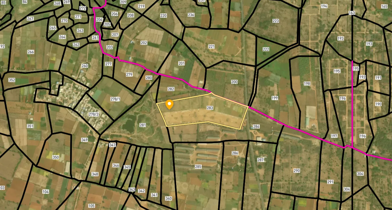
Access Survey NumbersAccess Haryana
Survey Numbers
Boundaries and numbers come from published state cadastral records. See all map layers.
Looking to sell your land in Haryana?

Browse all verified lands & plots in Haryana
More Layers in Haryana
See all 17 layers
Hodal Masterplan 2031: DTCP Zone Check and Land Use Guide
View Hodal Masterplan as a live map overlay – check any plot's land use zone for free on 1acre.in. Hodal Masterplan 2031...

Kot - Behla Masterplan
View Kot - Behla Masterplan as a live map overlay – check any plot's land use zone for free on 1acre.in. Panchkula Kot B...

Mansa Devi Complex (MDC) Panchkula: HSVP Zone Check and Plot Guide
View Mansa Devi Complex Masterplan as a live map overlay – check any plot's land use zone for free on 1acre.in. Mansa De...
More Layers in Haryana
Hodal Masterplan 2031: DTCP Zone Check and Land Use Guide
View Hodal Masterplan as a live map overlay – check any plot's land use zone for free on 1acre.in. Hodal Masterplan 2031...
Kot - Behla Masterplan
View Kot - Behla Masterplan as a live map overlay – check any plot's land use zone for free on 1acre.in. Panchkula Kot B...
Mansa Devi Complex (MDC) Panchkula: HSVP Zone Check and Plot Guide
View Mansa Devi Complex Masterplan as a live map overlay – check any plot's land use zone for free on 1acre.in. Mansa De...
Frequently Asked Questions
Yes. The 227 km six-lane access-controlled expressway opened on 1 August 2022, reducing Ambala-Narnaul travel time from 9-10 hours to 4-5 hours. Real estate activity has picked up around the 16 authorised interchanges, particularly in Kaithal, Jind, Charkhi Dadri and Mahendragarh districts.
A CLU permits conversion of agricultural or controlled-area land to a different use category, granted by the Director, DTCP under the Punjab Scheduled Roads and Controlled Areas Act 1963. A colonizer licence under the HDRUA Act 1975 permits actual development of a residential or commercial colony. Both are needed for plotted layouts.
DTCP enforcement targets colonies built on agricultural land without CLU and without a colonizer licence. The department has issued show-cause notices, written to registrar offices to halt sale deed execution, recommended FIRs against developers, and carried out demolition drives in Sohna, Pataudi, Farrukhnagar and Sultanpur belts.
A colonizer licence requires the developer to pay External Development Charges, Infrastructure Development Charges and submit an indemnity bond. Licensed colonies follow town-level infrastructure norms and qualify for bank financing. Plots in unlicensed colonies offer no statutory protection and risk demolition under DTCP enforcement.
Yes for purchase under the Punjab Scheduled Roads Controlled Areas Act, but only farming is permitted without CLU. Conversion to residential or commercial use requires explicit DTCP approval. Plots advertised as "ready to build" near NH-152D interchanges without a CLU order are sub-registrar transactions with no construction rights.
The 86.5 km Paniyala-Barodameo link is a 6-lane access-controlled greenfield expressway connecting the southern end of NH-152D near Narnaul to the Delhi-Mumbai Expressway at Barodameo in Alwar. Once commissioned, it will lift logistics and real-estate value across the southern Trans-Haryana belt.
Yes. The Ambala-Saha Road has been widened at a distance of 23 km from NH-152D to ease access, and the state is pursuing acquisition of 2,300 acres to expand the centre. Industrial allotments through HSIIDC at Saha are the lowest-risk entry route compared to speculative private layouts nearby.
Yes. Haryana RERA registration is mandatory for plotted developments of eight plots or more, or 500 sq m and above. Verification on haryanarera.gov.in confirms layout sanction, possession timeline and escrow obligations. Unregistered projects offer no statutory consumer protection on this corridor.
NH-152D is 227 km long, built in eight packages by NHAI under Bharatmala Pariyojana. It is a six-lane, access-controlled greenfield expressway with a 70 metre right of way, 16 interchanges and two main toll plazas. It runs through eight Haryana districts and about 112 villages, and it opened to traffic in August 2022.
It starts at Gangheri village near Ismailabad in Kurukshetra district, where it meets NH-152 from Ambala, and ends on the Narnaul bypass (NH-148B) in Mahendragarh district, near the Rajasthan border. From there NH-148B runs about 45 km on to Kotputli on NH-48, completing the Ambala-Kotputli corridor.
The expressway passes through Kurukshetra, Kaithal, Karnal, Jind, Rohtak, Bhiwani, Charkhi Dadri and Mahendragarh districts. Towns reached through its interchanges include Pehowa, Kaul, Pundri, Pilu Khera, Julana, Kalanaur, Charkhi Dadri, Mahendragarh, Kanina and Narnaul. The road does not pass through town centres, so access is only at the 16 interchanges.
The nearest interchanges for Rohtak are Kila Zafargarh, south of Julana, on NH-352 via Lakhan Majra; Kharkara, on NH-9; and Kalanaur, on NH-709 from Bhiwani to Rohtak. They sit on Packages 5 and 6 of the expressway, between Julana and Charkhi Dadri. Rohtak city itself is linked to the expressway by these roads.
No. Two-wheelers, three-wheelers, tractors and other slow or non-motorised vehicles are not allowed on NH-152D, because it is an access-controlled expressway. Local traffic uses the state and national highways that cross it at the interchanges. For land buyers this also means a plot beside the carriageway gets no direct access from the expressway.
Source
Official National Highways Authority of India (NHAI) documents
Official Website
nhai.gov.in
Coordinate Reference System
EPSG:4326 (WGS 84)
Geometry Type
LineString / MultiLineString
Data Format
Vector (GeoJSON) + Raster Tiles
Last Verified
2026
Status
Active
Was this layer helpful?
Anything wrong, outdated, or missing we want to hear it.