Panchkula Masterplan
Panchkula Masterplan Preview
Try the Panchkula Masterplan on the map
Sign in once and explore the layer for a full day.
- No card details needed
- Find nearby verified lands for sale
Overview
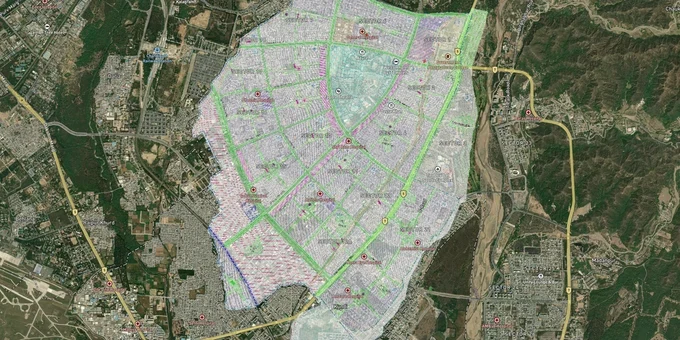
Before you sign anything in Panchkula, the Master Plan is the document that determines what your land is legally worth. Administered by the Haryana Shehri Vikas Pradhikaran (HSVP) and the Department of Town and Country Planning (DTCP), the plan covers Panchkula's 32 developed sectors plus the Panchkula Extension areas across the Ghaggar river. The Panchkula Master Plan zone check plot tool on 1acre gives you this information overlaid on satellite imagery. This page covers how to read the zone map, where the regulatory traps sit, and which corridors are actually worth your attention in 2026.
Change of Land Use (CLU) Fraud and Illegal Layouts: What the Department of Town and Country Planning (DTCP) Records Show in Panchkula
Panchkula has a well-documented pattern of unauthorised colonisation inside the notified urban area, and DTCP enforcement has been active. The mechanics are always the same: land is carved into plots and advertised without a valid DTCP licence, buyers register sale deeds for individual plots, and the colony is later demolished or frozen.
The table below shows the key zone categories under the Panchkula Master Plan and the CLU status each requires before construction or colony development can begin.
Zone
Permitted Use
CLU / DTCP Licence Required?
Common Fraud Pattern
Residential (HSVP Sectors)
Housing, group housing
No CLU needed if within licensed HSVP sector
Fake "HSVP approved" claims on unlicensed colonies
Residential (Extension areas)
Housing, subject to licenced colony
Yes, DTCP licence mandatory before plotting
Advertised plots without DTCP licence, FIR risk
Industrial
Non-polluting manufacturing
CLU mandatory; Micro, Small and Medium Enterprises (MSME) registration required
Agricultural land sold as "ready for industry" without CLU
Agricultural / Controlled Area
Farming only
Full CLU from DTCP Director required before any change of use
Plots sold on agricultural land inside controlled area without CLU
Green Belt / Open Space
No construction
Change of land use not permissible
Plots advertised adjacent to green belts with exaggerated area claims
The Panchkula Barwala area, now earmarked for Extension 2 sectors along NH-73, has seen demolitions of structures built without CLU permission as recently as 2025. If a broker cannot show you a copy of the DTCP licence number for the colony and the corresponding TCP Haryana approval letter, walk away before the paperwork starts.
Panchkula Extension 2, Kalka Highway and the Micro-Markets That Actually Have Traction
The original 32 Panchkula sectors are fully built out. HSVP has confirmed no room for further expansion inside the core. Every genuine growth play now sits in one of three corridors outside it, and they are not equal.
The table below maps the corridors as they stand against the Master Plan zones they fall within.
Corridor
Master Plan Zone
Key Driver
Known Risk
Extension 2 (Sectors 1–24, Kot Billa–Alipur, NH-73)
Residential / Mixed Use (Draft Development Plan; confirm current status on tcpharyana.gov.in)
Land pooling policy, MC-led development, plots at ₹50,000–₹1 lakh per sq yd (indicative; verify current rates) vs ₹2 lakh+ in prime sectors (indicative; verify current rates)
No land pooling policy formally notified in Haryana yet; timeline uncertain
Panchkula–Kalka Highway (DLF Valley corridor, Sector 14 Extension)
Residential, Real Estate Regulatory Authority (RERA)-registered projects
DLF Phase I plots appreciated from ₹2,000 to ₹8,000+ per sq ft (indicative; verify current rates) since 2010; Trident Hills Phase II live
Premium entry prices; Shivalik Hill proximity creates green buffer restrictions
Raipur Rani / Barwala (Tehsil-level, NH-73 industrial belt)
Industrial, Agricultural (conversion-dependent)
Industrial land at ₹70 lakh–₹6 crore (indicative; verify current rates) range; agricultural land at ₹22–₹35 lakh per bigha (indicative; verify current rates)
Any residential use requires full CLU; many listings advertise conversion potential not yet granted
The most misread corridor is Raipur Rani. It appears in broker pitches as the next growth pocket because of its location on the Chandigarh–Panchkula axis, but land there sits under agricultural or industrial zoning in the TCP Haryana controlled area. Residential use is not possible without a formal DTCP CLU, and that process is neither fast nor guaranteed. Buy agricultural land there for what it is, not for what a broker says it will become.
Was this layer helpful?
Anything wrong, outdated, or missing we want to hear it.
For Land Owners & Agents
Looking to sell your land in Haryana?
I want to sell my land in Panchkula Extension
10:32
Plz share your Land's location - We will list it on 1acre map, for Free.
10:32

For Land Buyers
Browse all verified lands & plots in Haryana
Every listing goes through our Preliminary Verification Process.
More Layers in Haryana
See all 13 layers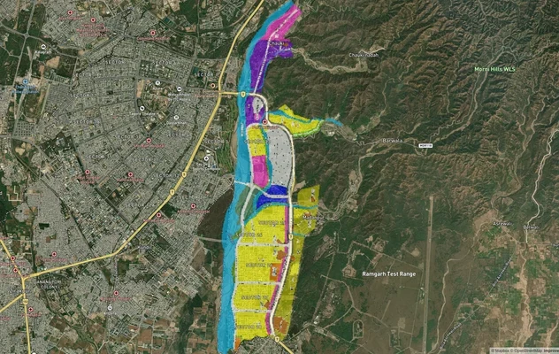
Panchkula Extension 1 Masterplan
View Panchkula Extension 1 Masterplan as a live map overlay – check any plot's land use zone for free on 1acre.in. Panch...

Panchkula Extension 2 (Alipur) Masterplan
View Panchkula Extension 2 (Alipur) Masterplan as a live map overlay – check any plot's land use zone for free on 1acre....
Hodal Masterplan 2031: DTCP Zone Check and Land Use Guide
View Hodal Masterplan as a live map overlay – check any plot's land use zone for free on 1acre.in. Hodal Masterplan 2031...
More Layers in Haryana
Panchkula Extension 1 Masterplan
View Panchkula Extension 1 Masterplan as a live map overlay – check any plot's land use zone for free on 1acre.in. Panch...
Panchkula Extension 2 (Alipur) Masterplan
View Panchkula Extension 2 (Alipur) Masterplan as a live map overlay – check any plot's land use zone for free on 1acre....
Hodal Masterplan 2031: DTCP Zone Check and Land Use Guide
View Hodal Masterplan as a live map overlay – check any plot's land use zone for free on 1acre.in. Hodal Masterplan 2031...