Jaipur Air Funnel Zones: Building Height Restrictions
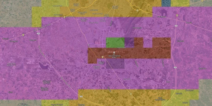
Jaipur Air Funnel Zones Preview
Try the Jaipur Air Funnel Zones on the map
Sign in once and explore the layer for a full day.
- No card details needed
- Find nearby verified lands for sale
Overview
Jaipur airport height restriction zones, mapped under AAI's Colour Coded Zoning Map (CCZM), regulate permissible building heights across a 20-km radius from Sanganer airport. The governing rules are the Ministry of Civil Aviation Height Restrictions Rules 2015 (G.S.R. 751(E)), which make an AAI NOC via NOCAS mandatory before any construction begins within this radius. Jaipur carries the tightest height threshold among comparable Indian cities: at 9 km from the airport, buildings are capped at just 19.6 m.
Regulatory Red Flags in Jaipur Airport Height Restriction Zones: The JDA Low Height Tag and What It Enforces
The JDA Master Development Plan 2025, approved in September 2011, explicitly designates large sections of land around Sanganer airport as "Low height Residential (Subject to Airport)." That designation is sourced from AAI's enforceable CCZM and is not a planning note. JDA has since amended its building bylaws under direct AAI recommendations made pursuant to G.S.R. 751(E). When the JDA land-use map marks a plot with that label, it means a funnel surface runs over it and vertical development rights are permanently restricted.
Rajasthan has codified specific caps through formal government action: maximum 10 metres within 200 metres of the airport boundary, up to 30 metres in the 450-500 metre band, and 34 metres beyond. Three high-rise buildings in Sanganer were stalled by direct state government intervention after civil aviation and intelligence reviews. The UDH division separately cancelled building permissions for high-rises in this corridor. In Jagatpura and Siddharth Nagar, G+3 structures sitting within 300 feet of the airport boundary wall came under formal scrutiny.
The regulatory exposure is active, not theoretical. Nationally, 40% of AAI NOC applications are rejected. Any structure above 15 m above ground level requires a height clearance NOC from AAI through NOCAS before a single brick is laid. Violations under the Aircraft Act can result in Occupancy Certificate denial, building permission cancellation, or demolition orders. These carry statutory force under aviation safety law, with no goodwill window for correction after construction begins.
The table below maps the Jaipur airport height restriction zones by distance band, based on state government notification and AAI CCZM rules.
Distance from Airport Boundary
Maximum Permitted Height
Approving Authority
Within 200 m
10 m
AAI mandatory NOC
200 m to 500 m
30 m
AAI NOC plus JDA
Beyond 500 m, within 20 km
Per CCZM colour grid
NOCAS; JDA if below Permissible Top Elevation
Distance from Airport Boundary
Maximum Permitted Height
Approving Authority
Within 200 m
10 m
AAI mandatory NOC
200 m to 500 m
30 m
AAI NOC plus JDA
Beyond 500 m, within 20 km
Per CCZM colour grid
NOCAS; JDA if below Permissible Top Elevation
If a broker cannot produce the CCZM grid reference for the specific survey number being evaluated in Sanganer or Jagatpura, verify independently on NOCAS and confirm the Permissible Top Elevation for that grid before proceeding further.
Sanganer, Jagatpura, and the 15 km Break: Development Rights Across Jaipur Airport Zones
The airport proximity spectrum in Jaipur splits into three distinct investment tiers with materially different height environments. Understanding which tier a plot sits in before negotiating price is not a formality; it determines whether the intended use is even legally viable.
Sanganer and the immediate airport boundary sit in the tightest restriction tier. Heights are government-enforced at 10-34 m, JDA bylaws have been formally amended, and multiple projects have been stalled by state authority. The investment case for land here rests on location premium, low-rise logistics, or hospitality use, not on vertical development potential. Buying for developer resale means working against a documented enforcement environment.
Jagatpura is the most actively misread corridor in this zone. High transactional volume and strong Tonk Road branding position it as a growth belt. In practice, much of Jagatpura sits inside AAI obstacle limitation surfaces that impose a G+3 practical ceiling. Existing buildings in Jagatpura and the adjacent Siddharth Nagar area have already faced compliance scrutiny from civil aviation authorities. A developer paying Tonk Road rates for a Jagatpura plot that cannot exceed G+3 is buying a constraint, not an opportunity.
The critical break point is Tonk Road at 15 km from the airport. Prosperiti's analysis of AAI CCZM data shows that in Jaipur, the height threshold stays low and largely flat up to the 15 km mark, then increases by approximately 600%. That inflection point changes development economics and therefore what land in this corridor is actually worth.
Corridor
Proximity to Airport
Height Environment
Investor Risk
Sanganer
0 to 3 km
10-34 m, state-enforced
High, active enforcement
Jagatpura and Siddharth Nagar
3 to 8 km
G+3 practical ceiling
Medium, compliance scrutiny
Tonk Road beyond 15 km
15 km or more
~600% height increase past threshold
Lower restriction
Jagatpura consistently prices as though it belongs to the open Tonk Road belt. The CCZM data does not agree.
Was this layer helpful?
Anything wrong, outdated, or missing we want to hear it.
For Land Owners & Agents
Looking to sell your land in Rajasthan?
I want to sell my land in Rajasthan
10:32
Plz share your Land's location - We will list it on 1acre map, for Free.
10:32

For Land Buyers
Browse all verified lands & plots in Rajasthan
Every listing goes through our Preliminary Verification Process.
More Layers in Rajasthan
See all 8 layers
Jaipur JDA Masterplan: Zone Check and Land Use Guide
View Jaipur Masterplan as a live map overlay – check any plot's land use zone for free on 1acre.in. Jaipur masterplan zo...

Alwar UIT Masterplan 2031: Zone Check and Land Use Guide
View Alwar Masterplan as a live map overlay – check any plot's land use zone for free on 1acre.in. Alwar Master Plan 205...
Jodhpur JODA Masterplan 2031: Zone Check and Land Use Guide
View Jodhpur Masterplan as a live map overlay – check any plot's land use zone for free on 1acre.in. Jodhpur masterplan ...
More Layers in Rajasthan
Jaipur JDA Masterplan: Zone Check and Land Use Guide
View Jaipur Masterplan as a live map overlay – check any plot's land use zone for free on 1acre.in. Jaipur masterplan zo...
Alwar UIT Masterplan 2031: Zone Check and Land Use Guide
View Alwar Masterplan as a live map overlay – check any plot's land use zone for free on 1acre.in. Alwar Master Plan 205...
Jodhpur JODA Masterplan 2031: Zone Check and Land Use Guide
View Jodhpur Masterplan as a live map overlay – check any plot's land use zone for free on 1acre.in. Jodhpur masterplan ...