
Jaipur JDA Masterplan: Zone Check and Land Use Guide
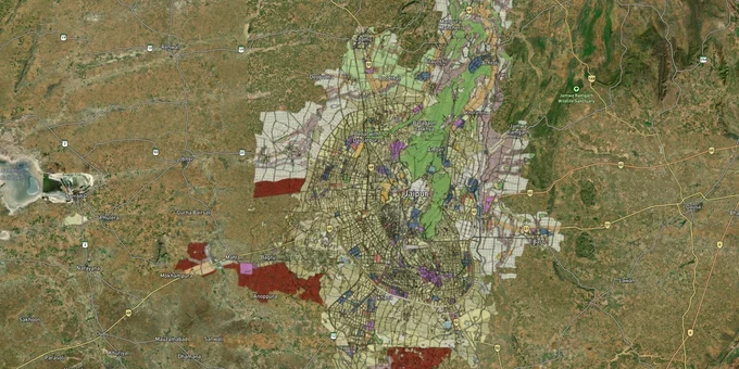

Jaipur Masterplan Preview
Try the Jaipur JDA Masterplan on the map
Sign in once and explore the layer for a full day.
- No card details needed
- Find nearby verified lands for sale
Overview
The JDA Masterplan 2025, formally the Master Development Plan 2025 (MDP-2025), is the governing land-use document for a 2,940 sq km region covering Jaipur city, 725 villages, and two municipal councils. Approved at the 60th Authority Meeting on 5 September 2011, it divides the entire region into five policy zones: U1, U2, U3, the ecological zone (G1/G2), and rural area. As of October 2026 it is still the plan in force: JDA extended it in 2025 until 5 September 2027, or until a new master plan is notified, whichever comes first. Its replacement, Master Plan 2047, has not been published as a draft on the JDA website. Whether you are buying a residential plot in Jagatpura or agricultural land near Kalwar Road, your plot's zone classification under this plan determines what you can build, whether a bank will finance the purchase, and whether the land can ever be legally converted. This page covers which plan applies today, what each land-use code means, the JDA zone-wise list, where the official PDF maps are published, the zone rules, the fraud patterns buyers encounter most often, and the growth corridors where the plan is creating real value.
Which JDA master plan applies in 2026: MDP-2025 or Master Plan 2047
Searches for a JDA master plan 2026 or a Jaipur master plan 2026 lead to the same document: there is no separate 2026 plan. MDP-2025 was due to lapse on 5 September 2025. A JDA notification in mid-2025 (the notice is dated 24 June 2025 and was reported on 4 July 2025) extended it for two years, to 5 September 2027, or until a new Master Development Plan is notified, whichever comes first. The next plan looks ahead to 2047. JDA invited bids to prepare it in July 2024, and its service portal runs a public questionnaire for MDP-2047, which is being planned for a population of up to 1.5 crore. As of October 2026, no draft of Master Plan 2047 has been published on the JDA website for objections, and a July 2026 report in Rajasthan Patrika said work on the new plan had not gained pace. The JDA region itself has grown. By October 2025 the state had notified the addition of 679 revenue villages, taking the region to about 6,000 sq km, and a revised notification in July 2026 added 41 villages and removed 12. In March 2026 the Rajasthan High Court imposed an interim stay on construction in 539 of the 679 newly added villages; the case is pending.
Which JDA master plan applies in 2026: MDP-2025 or Master Plan 2047
Plan or notification
Status as of October 2026
What it means for a buyer
MDP-2025 (approved 5 September 2011)
In force, extended to 5 September 2027
The MDP-2025 zone decides use, conversion and approvals
Master Plan 2047
Under preparation, no draft published
No 2047 zoning exists yet; treat any seller's "2047 zone" claim with caution
JDA region expansion (679 villages, 2025; revised July 2026)
Notified; High Court interim stay on construction in 539 of the 679 added villages since March 2026
Land in added villages is under JDA; in the 539 villages covered by the stay, building work is on hold
Land use codes explained: U1, U2 HIZ, U3, G1, G2 and rural area
Every part of the MDP-2025 land use map carries a policy zone code, and HIZ is the one most often misread. In the plan, HIZ means High Intensity Zone. Both U2 and U3 are split into a High Intensity Zone (HIZ) and a Low Intensity Zone (LIZ). The part that overlaps the G2 ecological buffer is LIZ, where FAR is limited to standard FAR and low-impact development is required. The rest is HIZ, the main area planned for urban growth. So U2 HIZ land use means land in the urbanisable fringe around the city that is outside the ecological buffer. In Hindi, it is the U2 उच्च सघनता क्षेत्र (high intensity zone), and U3 HIZ is the high intensity part of the transit corridor zone. Neither code means a plot is approved: agricultural land in U2 HIZ or U3 HIZ still needs 90A conversion and a JDA-sanctioned layout.
Land use codes explained: U1, U2 HIZ, U3, G1, G2 and rural area
Code
Name in MDP-2025
Hindi meaning
What the plan says
Area (sq km)
U1
Urban area
नगरीय क्षेत्र
Compact urban core and satellite towns
954
U2 HIZ
Urban area U2, High Intensity Zone
U2 उच्च सघनता क्षेत्र
Periphery of U1 planned for urban growth
391
U2 LIZ
Urban area U2, Low Intensity Zone
U2 निम्न सघनता क्षेत्र
U2 overlapping G2; standard FAR only
116
U3 HIZ / LIZ
Transit corridor development area
परिवहन कॉरिडोर विकास क्षेत्र
Influence area of NH, SH, Ring Road and bypasses: 1,000 m each side of an NH and 500 m of an SH
96 / 39
G1
Eco-sensitive area
पारिस्थितिक संवेदनशील क्षेत्र
Rivers, ponds, forests and hills; conservation
281
G2
Buffer to G1
बफर क्षेत्र
Eco-friendly housing, biotech parks, motels, resorts; other uses discouraged
196
Ecological area
Ecological area
पारिस्थितिक क्षेत्र
Agriculture and eco-sensitive uses
417
Rural area
Rural area
ग्रामीण क्षेत्र
Agriculture-based rural economy
450
JDA zone-wise list: administrative zones in Jaipur
JDA uses two kinds of zone, and they are often confused. Planning zones (1 to 16, with Zone 11 split into 11A and 11B) come from MDP-2025 and are the basis of the zonal development plans. Administrative zones are the JDA offices that handle pattas, 90A conversion and layout approvals. A plot's administrative zone does not tell you its land use; check its MDP-2025 code for that. JDA's administrative zone map dated 20 December 2018 shows 18 zones: Zones 1 to 14 and four Prithviraj Nagar (PRN) zones, PRN North-I, PRN North-II, PRN South-I and PRN South-II. After the region expansion, JDA demarcated the roughly 6,000 sq km region into 27 administrative zones in October 2025.
JDA zone-wise list: administrative zones in Jaipur
Zone
Change in October 2025
Areas confirmed in official maps or reports
Zones 1 to 8
Unchanged
Zone 2 includes Akera Dungar village (JDA enforcement, September 2025)
Zone 9
Boundary modified
Villages from Sanganer
Zone 10
Boundary modified
Added villages from the Nayla and Bhuj revenue circles of Jamwaramgarh tehsil
Zone 11
Boundary modified
Bounded by Ajmer Road to the north and Mauzamabad and Phagi to the west
Zones 12 to 14
Boundary modified
Not itemised in public reports
From PRN North and PRN South
Two zones carved out
Prithviraj Nagar North and South areas
Zones 15 to 25
Newly created
Not itemised in public reports
JDA has not published a locality-by-locality list as text. The official boundaries are on the JDA website under Town Planning: the Zonal Boundary map (Administrative Zone Boundary) and the Administrative Zone JDA map (Key Maps). The JDA home page also has a Know Your Zone service. Because zone numbers changed in 2025, confirm the current zone with the JDA office before filing a 90A or patta application, and view the plot's land use on the 1acre map layer.
JDA master plan PDF download, zonal plans and road plans
The official files are published on the JDA website (jda.rajasthan.gov.in) under Town Planning; 1acre does not host them. The MDP-2025 page was last updated on 15 October 2026 and still carries only the 2025 plan documents, so a JDA master plan 2026 PDF download is the same MDP-2025 set. A Hindi version of the page exists, but the volumes are in English.
JDA master plan PDF download, zonal plans and road plans
Document
What it contains
Where on the JDA website
Volumes 1 to 4
Existing profile; Development Plan 2025 (policy zones, planning zones); satellite towns and growth centres; Development Promotion and Control Regulations
Master Development Plan 2025
Mapbooks 1 to 4
Base map, existing map, land utilisation map, land use plan
Master Development Plan 2025
Zonal development plans
Approved plans for planning zones 1 to 16 (with Zone 10 revised, 11A and 11B), as high-resolution images
Zonal Development Plan
Sector plans
71 approved sector plans, for example Sector 2 (Vidyut Nagar, Moti Nagar, Chitrakoot, Ajmer Road)
Sector Plan
Road network plans
Draft plans for planning zones 11A, 12, 13, 14, 15 and 16
Road Network Plan
Sector roads
JDA sector road data
Notice Board, JDA Sector Road
Interactive map
MDP-2025 land use on a GIS map
Jaipur Master Plan 2025 GIS portal
Searches for a JDA site plan usually mean the approved layout of a scheme or the building map of a plot. These are not in the master plan PDFs: JDA lists approved building maps on its notice board, and a colony's sanctioned layout comes with its 90A and layout approval. ZDP roads (roads proposed in a zonal development plan) and sector roads appear in the zonal and sector plans. Check the JDA road plan and sector road map before buying, because a proposed road can cut through a plot.
Unapproved colonies and the 90A trap: Jaipur's most common land fraud
The single biggest risk in buying Jaipur Masterplan zone land is purchasing a plot in a colony developed without JDA approval. This is not a theoretical risk. In December 2025, JDA enforcement demolished illegal colony development at three sites, Vijaypura (Agra Road), Gram Machwa (Kalwar Road), and Gram Pachar, all built on agricultural land without any conversion or layout sanction. The buyers in those colonies had no recourse. The drive has continued in 2026. In the latest reported colony demolitions, in April 2026, JDA razed two colonies of about 4 bigha each on JDA land at Jaisinghpura Khor and cleared Radha Vallabhnagar in Sumel for the third time, with JDA saying it would file FIRs against repeat violators. Later that month JDA tore up the roads and boundary walls of an unapproved colony on about 6 bigha of agricultural land at Kalwad village and said it would recover the cost of the action from the developer. Each time, JDA asked buyers to check a colony's approval in JDA records before paying. The mechanism is almost always the same: a coloniser buys agricultural khasra land in a rural or U2 zone, plots it out, and sells on the basis of a society patta, a document issued internally by the society, not by any government authority. The society patta looks like an ownership document but carries no legal weight under the JDA Act 1982. The table below shows the four zone types most frequently misrepresented to buyers.
Unapproved colonies and the 90A trap: Jaipur's most common land fraud
Zone
What sellers claim
Legal reality
G2 (ecological buffer)
"Farmhouse zone, you can build"
Not a general building zone: MDP-2025 allows only low-impact uses such as eco-friendly housing, biotech parks, motels and resorts and discourages the rest; narrow exemptions are cited for marriage gardens on 1 ha and medical institutes on 2 ha on an 18 m road; Rajasthan HC has separately flagged unauthorized zone changes in ecological land
Rural area
"Just outside city limits, cheap entry"
Not planned for urbanisation; kept for the agriculture-based rural economy, with limited non-farm uses such as large industries only after permissions like EIA; not eligible for residential layout approval
U2 (agricultural portions)
"Future development zone, assured returns"
Residential layouts permitted only after 90A conversion and JDA layout sanction; plots sold before conversion have no bank financing or building approval eligibility
U1 unapproved colonies
"Colony regularization is coming"
Regularization is not guaranteed; HC orders have directed JDA to resist regularizing violations; the Rajasthan High Court has directed removal of unauthorized constructions across 87 colonies on Housing Board land in Sanganer, and in October 2025 the Supreme Court declined to interfere after the state government appealed
Before you pay a token, ask for the 90A conversion certificate and the JDA-sanctioned layout plan. If either is missing, the plot cannot be registered, cannot get a home loan, and cannot receive a building plan approval, regardless of how long the colony has existed.
Growth corridors under the JDA Masterplan 2025: where zone classification drives value
The Jaipur Master Development Plan 2025 (MDP-2025) is not uniformly investable. U1 is the core urban zone, fully developed, legally safest, but with the lowest appreciation upside. The real action for buyers seeking growth is in U2 and the U3 corridor zones, where Masterplan classification, infrastructure projects, and 90A conversion status combine to determine whether a parcel is a genuine opportunity or a trap. The corridors below are all within the JDA Masterplan 2025 planning area and each has a distinct risk-return profile.
Growth corridors under the JDA Masterplan 2025: where zone classification drives value
Corridor / Locality
Zone
Primary growth driver
Key risk
Ajmer Road (Bhankrota to Mahapura)
U3 / U2
Delhi-Mumbai Industrial Corridor alignment, 6-lane expressway
Verify plot is not in remaining agricultural pocket without 90A
Kalwar Road (Machwa, Pachar)
U2
Emerging suburban; major road development ongoing; lower entry price
JDA demolished illegal colonies here in Dec 2025 and at Kalwad in April 2026; verify layout sanction
Tonk Road (Jagatpura, Sitapura)
U1 / U2 HIZ
Established IT and industrial presence; retail hubs; consistent rental demand; Jaipur Metro Phase 2 (Prahladpura to Todi Mod, approved April 2026, target September 2031) will serve Sitapura and Tonk Road
Premium pricing; fewer raw land opportunities
Ring Road alignment
U3 / U2
Southern Ring Road (Mahapura on Ajmer Road to Bagrana on Agra Road) is built; northern arms to Chandwaji on Delhi Road are proposed, with service roads
Northern section is still a paper corridor; road completion timelines historically run 5-7 years
Bassi and Sikar Road
U2
Satellite town designation in MDP; long-horizon appreciation
5+ year investment horizon; limited current infrastructure
The most misunderstood corridor is Kalwar Road. It appears cheap relative to Ajmer Road, but JDA has been active with demolitions there precisely because colonisers are exploiting the price gap between agricultural land and converted U2 land. A verified, 90A-converted layout on Kalwar Road is a legitimate opportunity. An unconverted society-patta plot in the same village is not.
Data Sources & Verification
This page is based on JDA's own planning documents and maps, read in October 2026, with news reports used only for events JDA does not publish as notices, such as enforcement drives and court orders. Zone codes, areas and rules come from the MDP-2025 volumes. Where a fact could not be confirmed from an official or established source, it was left out.
* JDA, Master Development Plan 2025 page: list of volumes and mapbooks, last update date * JDA, MDP-2025 Volume 2 (Development Plan 2025): policy zones, HIZ and LIZ, U3 buffer widths, land utilisation areas, planning zones * JDA, MDP-2025 Volume 4 (Development Promotion and Control Regulations): land use categories * JDA, Zonal Development Plan, Approved Sector Plans and Draft Road Network Plan pages: zonal, sector and road plans available * JDA, Administrative Zone map (20 December 2018), Zonal Boundary and Key Maps pages: administrative zones * JDA, MDP-2047 questionnaire: status and population target of the 2047 plan * JDA notice extending MDP-2025 (June 2025, as reproduced and reported in July 2025) and Rajasthan Patrika (July 2026): validity to 2027 * First India (July 2024, October 2025) and Rajasthan Patrika (March, July and October 2026): 2047 plan tender, region expansion, 27 zones, revised notification, High Court stay * Rajasthan Patrika (September 2025, December 2025, April 2026): JDA enforcement against illegal colonies * First India (August 2025) and Deccan Herald (October 2025): Sanganer Housing Board colonies case * Prime Minister's Office and Business Standard (April 2026): Jaipur Metro Phase 2 * Maritime Gateway (February 2024): Ring Road northern arms
For Land Owners & Agents
Looking to sell your land in Rajasthan?
I want to sell my land in Rajasthan
10:32
Plz share your Land's location - We will list it on 1acre map, for Free.
10:32

For Land Buyers
Browse all verified lands & plots in Rajasthan
Every listing goes through our Preliminary Verification Process.
More Layers in Rajasthan
See all 16 layers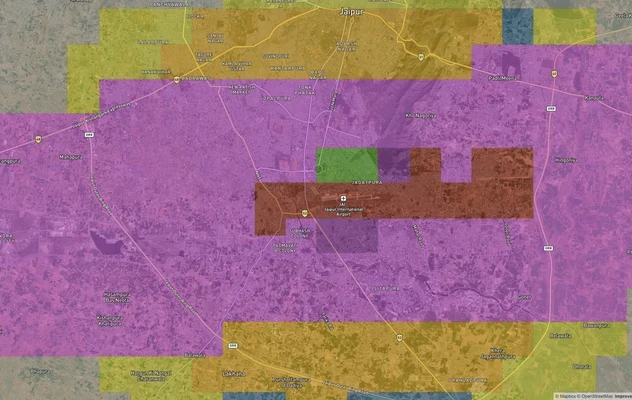
Jaipur Air Funnel Zones: Building Height Restrictions
View Jaipur Air Funnel Zones on a live map – check height clearance restrictions on any plot for free on 1acre.in. Jaipu...

Ajmer Masterplan Land: ADA Zones, 90A Rules | 1acre.in
Ajmer masterplan land zone: what every buyer must verify before signing
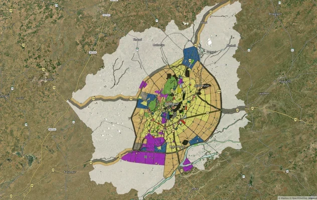
Jodhpur JODA Masterplan 2031: Zone Check and Land Use Guide
View Jodhpur Masterplan as a live map overlay – check any plot's land use zone for free on 1acre.in. Jodhpur masterplan ...
More Layers in Rajasthan
Jaipur Air Funnel Zones: Building Height Restrictions
View Jaipur Air Funnel Zones on a live map – check height clearance restrictions on any plot for free on 1acre.in. Jaipu...
Ajmer Masterplan Land: ADA Zones, 90A Rules | 1acre.in
Ajmer masterplan land zone: what every buyer must verify before signing
Jodhpur JODA Masterplan 2031: Zone Check and Land Use Guide
View Jodhpur Masterplan as a live map overlay – check any plot's land use zone for free on 1acre.in. Jodhpur masterplan ...
Frequently Asked Questions
Yes. JDA extended the Masterplan 2025 by two years via a notification dated 24 June 2025 (reported on 4 July 2025). It remains legally valid until 5 September 2027, or until the new Masterplan 2047 is officially notified, whichever comes first.
JDA is preparing a new Masterplan for the horizon year 2047. As of October 2026, no draft has been published for objections, so the extended Masterplan 2025 remains in force until it is notified. Separately, the state expanded JDA's jurisdiction from roughly 3,000 sq km to approximately 6,000 sq km in 2025 by adding 679 villages, and JDA reorganised its administrative zones from 18 to 27. If your plot falls in a newly added village, it now comes under JDA, which affects development rights and land value, but since March 2026 the Rajasthan High Court has stayed construction in 539 of the 679 added villages, so check whether your village is one of them.
Enter your khasra number in the JDA land-use map tool at jda.rajasthan.gov.in, or use the Jaipur Masterplan overlay on 1acre (Premium) to check the exact zone (U1, U2, U3, G1/G2, or rural) directly on an interactive map.
Only after 90A conversion approval and JDA layout sanction. Without both, U2 agricultural land cannot be registered, is ineligible for home loans, and cannot receive building plan approval.
A society patta is issued by a housing society, not the government. It has no legal validity for registration or bank financing unless backed by a 90A conversion certificate and JDA-sanctioned layout.
Strictly limited. MDP-2025 treats G2 as a buffer to the G1 eco-sensitive area and allows only low-impact uses such as eco-friendly housing, biotech parks, motels and resorts; other uses are discouraged. Marriage gardens on 1-hectare plots and medical institutes on 2-hectare plots abutting an 18-metre road are permitted. Any construction needs JDA approval for that specific use.
Use the JDA landuse maps on jda.rajasthan.gov.in, or the Jaipur Masterplan layer on 1acre (Premium) to locate your survey number and confirm zone classification directly on an interactive map.
U1 is the developed urban core, legally safest, highest cost. U2 is the mixed periphery with growth potential but requires 90A conversion. U3 runs along highways and ring roads with strong appreciation potential but slow infrastructure timelines.
JDA demolished illegal colony development at three sites, Vijaypura (Agra Road), Gram Machwa (Kalwar Road), and Gram Pachar, in December 2025. In September 2025 it also razed an unapproved colony on about 17 bigha of agricultural land at Akera Dungar in Zone 2. The Rajasthan High Court separately directed removal of unauthorized constructions across 87 colonies in Sanganer.
Yes. JDA approval confirms the layout is sanctioned, not the seller's title chain. A title search and encumbrance certificate remain essential to confirm there are no prior sales, mortgages, or ownership disputes on the specific plot.
In the JDA Masterplan 2025, U2 is the urban fringe around the U1 core, and HIZ means High Intensity Zone. U2 HIZ is the part of U2 outside the G2 ecological buffer, planned for urban growth. In Hindi it is the U2 उच्च सघनता क्षेत्र. U3 HIZ is the same idea along highways and the Ring Road. Agricultural land in U2 HIZ still needs 90A conversion and a JDA layout sanction before you can build.
There is no separate 2026 plan. The Masterplan 2025, extended to 5 September 2027, is the current plan. Its four volumes and four mapbooks, including the land use plan, are published as PDFs on the JDA website under Town Planning, Master Development Plan 2025. A Hindi version of the page exists, though the volumes are in English. The zonal development plans and sector plans are on separate pages in the same menu.
JDA had 18 administrative zones (Zones 1 to 14 and four Prithviraj Nagar zones) until October 2025, when it divided the expanded 6,000 sq km region into 27 zones. Zones 1 to 8 were unchanged and Zones 15 to 25 are new. The official zone boundary maps are on the JDA website under Town Planning, Administrative Zone Boundary and Key Maps, and the home page has a Know Your Zone service.
The master plan sets the land use policy for the whole region, such as U1, U2 or G2. A zonal development plan (ZDP) details one planning zone: land use of each area, ZDP roads and facilities. Under MDP-2025, Jaipur has approved zonal development plans for planning zones 1 to 16, published on the JDA website. Sector plans go one level further for named localities. A plot should match all three.
No. JDA's website lists only the Master Development Plans for 1991 (extended to 1998), 2011 and 2025. The 2025 plan has been extended to 5 September 2027, and the next plan is being prepared for 2047. The 2031 horizon belongs to other Rajasthan cities, such as the Alwar, Udaipur and Jodhpur master plans. For Jaipur, use MDP-2025 until a new plan is notified.
JDA publishes sector road data on its notice board (JDA Sector Road), 71 approved sector plans under Town Planning, and draft road network plans for planning zones 11A, 12, 13, 14, 15 and 16. Together these show the sector roads and planned road widths around a plot. Check them before buying, because land on a proposed road alignment cannot be built on.
Source
Official Jaipur Development Authority (JDA) documents
Official Website
jda.rajasthan.gov.in
Coordinate Reference System
EPSG:4326 (WGS 84)
Geometry Type
Polygon / MultiPolygon
Data Format
Vector (GeoJSON) + Raster Tiles
Last Verified
2026
Status
Active
Was this layer helpful?
Anything wrong, outdated, or missing we want to hear it.