Ahmedabad Air Funnel Zones: Building Height Restrictions
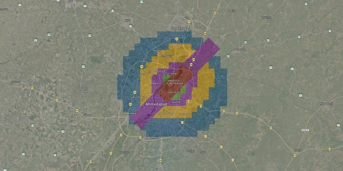
Ahmedabad Air Funnel Zones Preview
Try the Ahmedabad Air Funnel Zones on the map
Sign in once and explore the layer for a full day.
- No card details needed
- Find nearby verified lands for sale
Overview
Buying land or a flat near Sardar Vallabhbhai Patel International Airport (SVPIA) in Ahmedabad means your plot falls inside a legally regulated airspace layer governed by AAI's Color Coded Zoning Map (CCZM). This is the Ahmedabad airport height restriction zone land-buying check that most buyers skip, and it costs them later. Every structure within 20 km of the airport's aerodrome reference point requires a No Objection Certificate from AAI under the Ministry of Civil Aviation (Height Restrictions for Safeguarding of Aircraft Operations) Rules, 2015. SVPIA's single runway 05/23 runs northeast to southwest, which means the funnel zone extends directly over densely built corridors north and south of the airport. This page explains exactly what the CCZM zones mean, where the demolition risk is real, and how to check your plot before any money changes hands.
Ahmedabad Airport OLS Violations: Why 46 Demolition Orders Were Issued Near SVPIA
Ahmedabad has a documented, not theoretical, demolition problem. Following a 2022 aeronautical survey, the DGCA issued 46 demolition notices in January 2024 under the Aircraft (Demolition of Obstructions) Rules, 1994. As of November 2025, 13 of those structures are being razed by AMC because the owners did not comply. Investigators found that most violations arose from a specific and avoidable error: builders declared incorrect plinth elevations, which made their AMSL height appear compliant when the actual structure was not.
DGCA and AAI now require AMC and AUDA to conduct physical on-site elevation checks before issuing any Building Use (BU) permission near SVPIA. The table below shows the six color-coded height-control zones that now govern all construction around the airport.
Zone
Max Permissible Height (AMSL)
NOC Requirement
Red
Highly restricted (immediate vicinity)
Mandatory AAI clearance
Grey
Up to 77 m
AAI NOC
Yellow
Up to 95 m
AAI NOC
Pink
Up to 115 m
AAI NOC
Green
Up to 135 m
AAI NOC
Blue
Up to 155 m
AAI NOC
Zone
Max Permissible Height (AMSL)
NOC Requirement
Red
Highly restricted (immediate vicinity)
Mandatory AAI clearance
Grey
Up to 77 m
AAI NOC
Yellow
Up to 95 m
AAI NOC
Pink
Up to 115 m
AAI NOC
Green
Up to 135 m
AAI NOC
Blue
Up to 155 m
AAI NOC
The trap most buyers fall into: the permissible height shown in the CCZM is measured in meters above mean sea level (AMSL), not above ground level. A plot on raised ground near the runway approach path may appear in a green or blue zone yet carry only a few meters of usable building height once site elevation is subtracted. Any developer who cannot give you a signed site elevation certificate from a licensed surveyor with WGS84 coordinates is not in compliance with current AUDA requirements, and that project cannot legally receive BU permission.
Hansol, Chandkheda and the SVPIA Funnel: Where the Ahmedabad Airport Zone Tightest Affects Buyers
SVPIA sits at Hansol, approximately 9 km north of Ahmedabad's city center. The runway runs northeast to southwest, which concentrates the most restrictive funnel zone over localities aligned with those approach and take-off paths. Corridors directly under the approach funnel carry the sharpest height caps: at 1,000 meters from the runway edge, the maximum permissible height is just 20 meters above ground.
The table below maps sourced locality data against zone risk for buyers.
Corridor / Locality
Zone Position
Growth Driver
Key Risk
Hansol
Immediately adjacent to airport
Metro Phase II extension (Koteshwar–Airport)
Red/Grey zone; most buildings require AAI clearance regardless of height
Chandkheda
North of airport, outside primary funnel
Metro connectivity, GIFT City proximity
Yellow–Pink zone: height gains allowed but AMSL calculation still critical
Sabarmati / Motera
South of airport, near runway 23's end
Motera Stadium, metro Phase I
Verify funnel alignment before purchase; approach path extends this direction
Gota / Jagatpur
Outer belt, east of airport
Affordable housing demand
Green–Blue zone: higher permissible heights, standard NOCAS check sufficient
The most misread corridor is Chandkheda. Brokers routinely market it as fully outside the airport zone. It is not; it sits in a transition between yellow and pink zones, meaning mid-rise projects above 95 meters AMSL still require a separate AAI NOC. For reference, Ahmedabad's ground elevation is roughly 53 metres AMSL, which means a Yellow-zone plot in Chandkheda yields about 42 meters of buildable height before an NOC is required, fewer floors than many projects in that market currently advertise.
Was this layer helpful?
Anything wrong, outdated, or missing we want to hear it.
For Land Owners & Agents
Looking to sell your land in Gujarat?
I want to sell my land in Gujarat
10:32
Plz share your Land's location - We will list it on 1acre map, for Free.
10:32

For Land Buyers
Browse all verified lands & plots in Gujarat
Every listing goes through our Preliminary Verification Process.
More Layers in Gujarat
See all 11 layers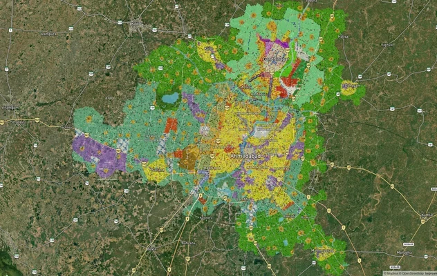
Ahmedabad - Gandhinagar Masterplan
View Ahmedabad - Gandhinagar Masterplan as a live map overlay – check any plot's land use zone for free on 1acre.in. Ahm...
GIFT City Masterplan: GIFT UDA and GUDA Zone Check
View GIFT City Masterplan as a live map overlay – check any plot's land use zone for free on 1acre.in. GIFT City Master ...
Vadodara VUDA Masterplan 2031: Zone Check and Land Use Guide
View Vadodara Masterplan as a live map overlay – check any plot's land use zone for free on 1acre.in. Vadodara VUDA Mast...
More Layers in Gujarat
Ahmedabad - Gandhinagar Masterplan
View Ahmedabad - Gandhinagar Masterplan as a live map overlay – check any plot's land use zone for free on 1acre.in. Ahm...
GIFT City Masterplan: GIFT UDA and GUDA Zone Check
View GIFT City Masterplan as a live map overlay – check any plot's land use zone for free on 1acre.in. GIFT City Master ...
Vadodara VUDA Masterplan 2031: Zone Check and Land Use Guide
View Vadodara Masterplan as a live map overlay – check any plot's land use zone for free on 1acre.in. Vadodara VUDA Mast...