Dholera Air Funnel Zones: Building Height Restrictions
Dholera Air Funnel Zones Preview
Try the Dholera Air Funnel Zones on the map
Sign in once and explore the layer for a full day.
- No card details needed
- Find nearby verified lands for sale
Overview
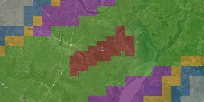
Every plot within 20 km of the Dholera International Airport's Aerodrome Reference Point falls under an AAI-regulated airspace layer. This is the Dholera Airport height restriction zone land buying check that almost no broker explains upfront. The airport, currently under construction near Navagam village in Dholera taluka, Ahmedabad district, is being developed by Dholera International Airport Company Limited (DIACL) across a 1,426-hectare site. Under the Ministry of Civil Aviation (Height Restrictions for Safeguarding of Aircraft Operations) Rules, 2015, every structure in the zone requires a verified height clearance.
Why the Dholera Airport CCZM Creates a Silent Height Cap Over TP1 and TP2 Plots
Dholera is unique among Indian real estate markets. Buyers are checking TP scheme approvals, NA status, and DSIRDA sanctions, which is correct. What almost none of them are checking is whether their DSIRDA-approved plot also falls inside the AAI air funnel zone, which imposes a completely separate, legally senior height cap that DSIRDA itself cannot override.
Under the MoCA 2015 Rules, AAI issues Color Coded Zoning Maps (CCZM) covering all areas within 20 km of an airport's Aerodrome Reference Point. The CCZM assigns each grid a permissible top elevation measured in meters above mean sea level (AMSL). The maximum permissible height for any structure is calculated as the CCZM permitted top elevation minus the site elevation. Dholera's terrain sits at roughly 10 to 15 meters AMSL, meaning the effective building height ceiling is considerably tighter than buyers assume when they read only the DSIRDA General Development Control Regulations (GDCR). The table below shows the standard AAI CCZM height bands relevant to an under-construction greenfield airport.
Zone
Typical Distance from ARP
Max Permissible Height (AMSL)
AAI NOC Required?
Red / Inner
Immediately adjacent (0–1 km)
Highly restricted
Yes, mandatory clearance
Grey
1–3 km
Up to 77 m AMSL
Yes, AAI NOC
Yellow
3–6 km
Up to 95 m AMSL
Yes, AAI NOC
Pink
6–10 km
Up to 115 m AMSL
Yes, AAI NOC
Green
10–15 km
Up to 135 m AMSL
Yes, AAI NOC
Blue
15–20 km
Up to 155 m AMSL
Yes, AAI NOC
The critical trap: AAI's rules apply from the date the airport is technically cleared, not from the date operations begin. Dholera received site clearance in July 2014 and environmental ministry approval in December 2015. The CCZM obligation has therefore been active for years, covering plots that sellers routinely market as unrestricted. If a developer cannot show you a NOCAS-generated height clearance letter alongside the DSIRDA NOC, the project has not completed its full legal stack.
Was this layer helpful?
Anything wrong, outdated, or missing we want to hear it.
For Land Owners & Agents
Looking to sell your land in Gujarat?
I want to sell my land in Ahmedabad - Gandhinagar
10:32
Plz share your Land's location - We will list it on 1acre map, for Free.
10:32

For Land Buyers
Browse all verified lands & plots in Gujarat
Every listing goes through our Preliminary Verification Process.
More Layers in Gujarat
See all 9 layers
Ahmedabad - Gandhinagar Masterplan
View Ahmedabad - Gandhinagar Masterplan as a live map overlay – check any plot's land use zone for free on 1acre.in. Ahm...
GIFT City Masterplan: GIFT UDA and GUDA Zone Check
View GIFT City Masterplan as a live map overlay – check any plot's land use zone for free on 1acre.in. GIFT City Master ...
Vadodara VUDA Masterplan 2031: Zone Check and Land Use Guide
View Vadodara Masterplan as a live map overlay – check any plot's land use zone for free on 1acre.in. Vadodara VUDA Mast...
More Layers in Gujarat
Ahmedabad - Gandhinagar Masterplan
View Ahmedabad - Gandhinagar Masterplan as a live map overlay – check any plot's land use zone for free on 1acre.in. Ahm...
GIFT City Masterplan: GIFT UDA and GUDA Zone Check
View GIFT City Masterplan as a live map overlay – check any plot's land use zone for free on 1acre.in. GIFT City Master ...
Vadodara VUDA Masterplan 2031: Zone Check and Land Use Guide
View Vadodara Masterplan as a live map overlay – check any plot's land use zone for free on 1acre.in. Vadodara VUDA Mast...