Ahmedabad - Gandhinagar Masterplan
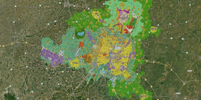
Ahmedabad Gandhinagar Masterplan Preview
Try the Ahmedabad - Gandhinagar Masterplan on the map
Sign in once and explore the layer for a full day.
- No card details needed
- Find nearby verified lands for sale
Overview
Buying land in the Ahmedabad-Gandhinagar region without checking the masterplan zone first is the single fastest way to lock capital in a plot you cannot build on. The Ahmedabad Urban Development Authority (AUDA) Revised Development Plan 2021 (RDP-2021) governs 1,866 sq km across Ahmedabad and its 169 surrounding villages, while the Gandhinagar Urban Development Authority (GUDA) Development Plan 2024 covers Gandhinagar capital city and 39 villages across 388 sq km. Together, these two plans define what you can build, how much floor space you can use, and whether your agricultural land can be legally converted at all. This page covers both plans, the regulatory traps specific to this combined urban region, and the growth corridors where zoning actively supports long-term land value. AUDA is also preparing DP-2041, a 20-year plan targeting the potential 2036 Olympics, which will supersede the current RDP-2021 framework.
Zone mismatches and agricultural conversion traps in AUDA and GUDA areas
The most expensive mistake buyers make in the Ahmedabad-Gandhinagar belt is purchasing land that sits inside one of the restricted agricultural zones without understanding the conversion rules. Under the AUDA Development Plan, NA (Non-Agricultural) conversion is permitted only in rare cases across roughly 68 villages within AUDA's jurisdiction, covering approximately 880 sq km of the total area. Where NA conversion has already been partially approved, only 5% construction is permissible on the farmland, not full residential development. If a broker is showing you an "NA plot" in this belt and cannot produce a verified Collector's permission order, treat it as unverified.
The zone code structure in AUDA's plan identifies 16 distinct zones. The table below shows the key ones buyers encounter in AUDA-governed land transactions.
Zone Code
Permitted Use
Build Without Conversion?
Commonly Misrepresented?
R-1
Residential (base Floor Space Index (FSI) 1.8, purchasable up to 2.7)
Yes, within General Development Control Regulations (GDCR) limits
No
R-2
Residential (base FSI 1.2, purchasable up to 1.8)
Yes, within GDCR limits
No
R-AH
Affordable housing along ~76 km Sardar Patel Ring Road belt
Only with Town Planning (TP) Scheme approval
Yes
IG
Industrial General
No residential use
Yes, sold as "convertible"
GME
Gamtal Extension (village core fringe)
Restricted, panchayat rules apply
Yes
Prime Agriculture
Protected double-cropped farmland
No conversion, construction prohibited
Frequently
In GUDA's jurisdiction, plots near the GIFT City expansion corridor carry an additional layer of complexity: in June 2024, the Gujarat government transferred planning authority over ~2,460 acres (996 hectares) of GIFT City's proposed expansion zone from GIFT UDA to GUDA, annulling previous notifications from November 2022 and November 2023. The existing ~1,065-acre GIFT City core remains under GIFT UDA. Any plot whose seller cites approvals under the pre-June 2024 GIFT UDA framework must be re-verified against GUDA's current zoning.
The Ahmedabad CID Crime branch has registered multiple land fraud cases involving forged ownership documents, including a ₹200 crore case in Vadaj where fraudsters cancelled a lis pendens through false information to obtain government clearance. Document forgery, rather than zone misrepresentation, is the dominant fraud pattern in Ahmedabad. Verify the seller's name on the 7/12 extract or Record of Rights (RoR) through the anyRoR Gujarat portal (anyror.gujarat.gov.in) or e-Dhara kiosk before any money changes hands.
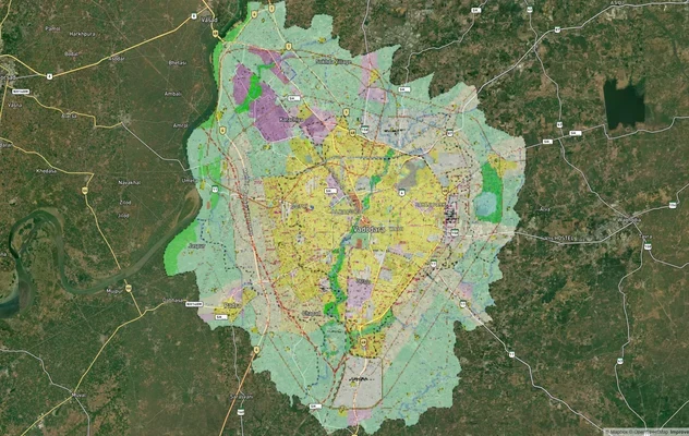
Where AUDA and GUDA zoning actively supports land value: corridors to watch
Not all land in the AUDA-GUDA zone is equally positioned for appreciation. The plan structure directly separates high-upside corridors from speculative ones.
The most clearly defined growth corridor in the plan is the 1 km band around the Sardar Patel Ring Road (76 km), which AUDA has designated as the R-AH Affordable Housing Zone. FSI of up to 4 is permitted here, supporting high-density residential development. Land in this belt sits inside active TP Schemes, and AUDA has been adding new schemes: in October 2025, the board approved seven new TP schemes covering Sanand, Godhavi, Kaneti, Nindrada, and Matnuru villages, adding approximately 1,000 hectares to the planned development zone.
Corridor
Zone Anchor
Growth Driver
Risk Level
SP Ring Road belt (1 km band)
R-AH, FSI up to 4
Active TP Schemes, transit access
Low to medium
SG Highway (Chandkheda, Tragad, Zundal)
R-1/R-2 under AUDA
GIFT City proximity, metro corridor
Low in TP areas
Sanand (Godhavi, Kaneti, Nindrada)
Industrial + new R-AH schemes (semiconductor hub — Micron, CG Power)
Auto and semiconductor industry (Micron, CG Power), 7 new TP schemes approved Oct 2025 (AUDA 307th board)
Medium
GIFT City periphery (Gandhinagar)
GUDA 2024, SEZ adjacency
IFSC expansion, ~2,460-acre GIFT expansion zone transferred to GUDA June 2024
Low in GUDA areas
Village fringe (GME / Prime Ag zones)
Restricted or prohibited
Speculative only
High
The most commonly misunderstood corridor is the village fringe zone east and north of Chandkheda. Brokers often present Prime Agriculture or GME-zoned parcels as "within AUDA limits and therefore buildable." Being within AUDA limits is not the same as being inside a TP Scheme or a development-ready zone. Confirm the TP Scheme number before treating any fringe parcel as investable.
Was this layer helpful?
Anything wrong, outdated, or missing we want to hear it.
For Land Owners & Agents
Looking to sell your land in Gujarat?
I want to sell my land in Gujarat
10:32
Plz share your Land's location - We will list it on 1acre map, for Free.
10:32

For Land Buyers
Browse all verified lands & plots in Gujarat
Every listing goes through our Preliminary Verification Process.
More Layers in Gujarat
See all 11 layers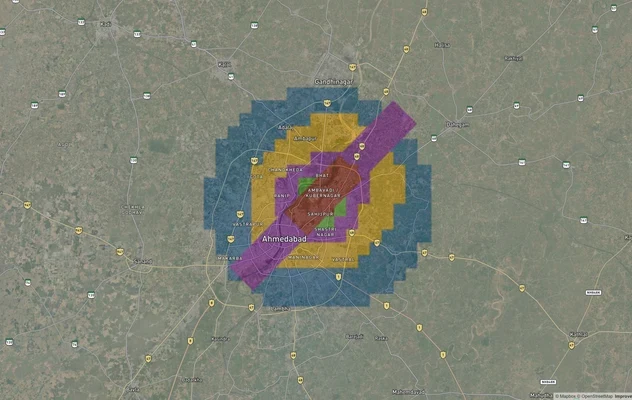
Ahmedabad Air Funnel Zones: Building Height Restrictions
View Ahmedabad Air Funnel Zones on a live map – check height clearance restrictions on any plot for free on 1acre.in. Ah...
GIFT City Masterplan: GIFT UDA and GUDA Zone Check
View GIFT City Masterplan as a live map overlay – check any plot's land use zone for free on 1acre.in. GIFT City Master ...
Vadodara VUDA Masterplan 2031: Zone Check and Land Use Guide
View Vadodara Masterplan as a live map overlay – check any plot's land use zone for free on 1acre.in. Vadodara VUDA Mast...
More Layers in Gujarat
Ahmedabad Air Funnel Zones: Building Height Restrictions
View Ahmedabad Air Funnel Zones on a live map – check height clearance restrictions on any plot for free on 1acre.in. Ah...
GIFT City Masterplan: GIFT UDA and GUDA Zone Check
View GIFT City Masterplan as a live map overlay – check any plot's land use zone for free on 1acre.in. GIFT City Master ...
Vadodara VUDA Masterplan 2031: Zone Check and Land Use Guide
View Vadodara Masterplan as a live map overlay – check any plot's land use zone for free on 1acre.in. Vadodara VUDA Mast...