
IAF Air Funnel Zones - Sirsa


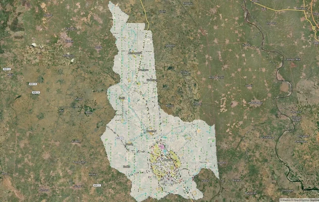
Iaf_air_funnel_zones_sirsa Preview
Try the IAF Air Funnel Zones - Sirsa on the map
Sign in once and explore the layer for a full day.
- No card details needed
- Find nearby verified lands for sale
Overview
The Sirsa Air Force Station land height restriction question begins with understanding why this base exists in the first place, since its original purpose shapes how it continues to operate today. Sirsa Air Force Station, under the Indian Air Force's Western Air Command, was established in the early-to-mid 1960s specifically as a diversionary airfield, designed to allow aircraft dispersal from primary hubs like Hindon Air Force Station and reduce vulnerability to concentrated attacks amid escalating tensions with Pakistan. Located at Sirsa in Haryana, it currently hosts No. 21 Squadron and No. 15 Squadron of the Indian Air Force. It covers the base's documented wartime attack history, why it has not developed a civil enclave the way a nearby sister base has, and what the officially named "Air Force Station" locality actually refers to for land buyers.
Sirsa Air Force Station Land: Regulatory Red Flags You Cannot Ignore
The first red flag is baked into the base's founding purpose. Sirsa was purpose-built as a dispersal and diversionary airfield, a design philosophy centred on spreading military assets across multiple locations rather than concentrating them at a single vulnerable point. Before the 1971 war, it served as a satellite and forward operating base for squadrons detached from Hindon Air Force Station, hosting Mystère IVa fighter-bombers and enabling rapid readiness exercises. A base founded on this strategic logic is structurally oriented toward maintaining operational flexibility and security margins around its perimeter, which supports a genuinely conservative approach to nearby civilian development, not a temporary wartime posture that has since relaxed.
The second red flag is a documented, historical attack on this specific base, which underscores why its restricted zone exists for real operational reasons rather than administrative caution. During the 1971 Indo-Pakistani War, the Pakistan Air Force launched a coordinated pre-emptive raid on twelve Indian Air Force stations, explicitly including Sirsa alongside Faridkot, Halwara, and other targets. The raid caused only pothole damage to the runway, which was quickly repaired, and Sirsa-based Mystère IV jets went on to strike Pakistan Army positions at the Battle of Sabuna Drain shortly after. This is not a hypothetical security concern; Sirsa has been a confirmed military target in an actual conflict, and that history is part of why its surrounding land continues to warrant careful clearance review.
The table below sets out the base's core confirmed parameters.
Parameter
Confirmed Detail
Command
Western Air Command
Current squadrons
No. 21 Squadron and No. 15 Squadron, IAF
Founding purpose
Diversionary/dispersal airfield to reduce vulnerability of concentrated IAF assets
Wartime history
Confirmed target in the 1971 Pakistan Air Force pre-emptive raid on 12 IAF stations
Runway
Single runway, aligned northeast-southwest (05-23)
Civil enclave status
None currently; base remains purely military
Parameter
Confirmed Detail
Command
Western Air Command
Current squadrons
No. 21 Squadron and No. 15 Squadron, IAF
Founding purpose
Diversionary/dispersal airfield to reduce vulnerability of concentrated IAF assets
Wartime history
Confirmed target in the 1971 Pakistan Air Force pre-emptive raid on 12 IAF stations
Runway
Single runway, aligned northeast-southwest (05-23)
Civil enclave status
None currently; base remains purely military
The third red flag is a useful comparison that buyers should not misapply. Ambala Air Force Station, also located in Haryana and also under Western Air Command, has developed a civil enclave, Ambala Domestic Airport, under the Government of India's UDAN regional connectivity scheme. Sirsa has not followed this same path and remains a purely military installation as of the most recent available information. Buyers should not assume Sirsa is quietly on a similar trajectory toward civilian passenger access simply because a comparable, geographically nearby Western Air Command base in the same state has already done so. The two bases have followed different development tracks, and any claim of upcoming civil access at Sirsa specifically needs independent confirmation rather than inference from Ambala's example.
The fourth consideration is a naming detail that matters directly for property searches. The immediate area surrounding the base is officially registered as its own locality named "Air Force Station," within Sirsa district, spanning roughly 7.74 square kilometres with a population of 10,361. Any land search referencing this specific locality name should be understood as referring to land directly adjacent to the operational airbase itself, not a loosely descriptive term.
Areas and Micro-Markets Affected by the Sirsa Restricted Zone
Land exposure near Sirsa Air Force Station concentrates most directly around the officially named "Air Force Station" locality itself, with the broader Sirsa city and surrounding towns carrying progressively lower but still relevant exposure.
Locality
Position Relative to the Base
Character
Restriction Exposure
"Air Force Station" locality
Officially registered village directly surrounding the base
Population 10,361 across 7.74 sq km, within Sirsa district
Highest exposure; this locality's name itself denotes direct adjacency to the airfield
Sirsa city core
District headquarters, Hisar Division
Established Haryana town, population over 200,000
Moderate exposure depending on exact distance and bearing from the runway
Rania, Kalanwali, Ellenabad
Nearby towns in Sirsa district
Established regional settlements
Generally lower exposure, but proximity should still be individually verified
Broader Sirsa district (Ghaggar belt)
Surrounding agricultural region
Agricultural land along the Ghaggar River corridor
Exposure varies significantly by actual distance to the airfield
Locality
Position Relative to the Base
Character
Restriction Exposure
"Air Force Station" locality
Officially registered village directly surrounding the base
Population 10,361 across 7.74 sq km, within Sirsa district
Highest exposure; this locality's name itself denotes direct adjacency to the airfield
Sirsa city core
District headquarters, Hisar Division
Established Haryana town, population over 200,000
Moderate exposure depending on exact distance and bearing from the runway
Rania, Kalanwali, Ellenabad
Nearby towns in Sirsa district
Established regional settlements
Generally lower exposure, but proximity should still be individually verified
Broader Sirsa district (Ghaggar belt)
Surrounding agricultural region
Agricultural land along the Ghaggar River corridor
Exposure varies significantly by actual distance to the airfield
The "Air Force Station" locality deserves the most direct attention on this list, precisely because its official name confirms what its geography already implies. With just over 10,000 residents in a compact 7.74 square kilometre footprint immediately around the base, any construction plan here needs runway-alignment-specific verification before proceeding, given both the base's founding dispersal-and-security purpose and its documented history as a wartime target.
Sirsa city itself, while carrying a meaningfully larger population and a more diversified local economy, still needs the same careful, distance-and-bearing-specific verification rather than a blanket assumption that its status as the district headquarters places it safely outside restricted airspace. As with any funnel zone evaluation, the runway's northeast-southwest alignment matters more than straight-line distance from the base.
Was this layer helpful?
Anything wrong, outdated, or missing we want to hear it.

Access Survey NumbersAccess Haryana
Survey Numbers
Boundaries and numbers come from published state cadastral records. See all map layers.
Looking to sell your land in Haryana?

Browse all verified lands & plots in Haryana
More Layers in Haryana
See all 17 layers
Ambala Chandigarh Air Funnel Zones: Height Rules
Check IAF and AAI air funnel height restrictions around Ambala Air Force Station and Chandigarh's airport before buying ...
Hodal Masterplan 2031: DTCP Zone Check and Land Use Guide
View Hodal Masterplan as a live map overlay – check any plot's land use zone for free on 1acre.in. Hodal Masterplan 2031...

Kot - Behla Masterplan
View Kot - Behla Masterplan as a live map overlay – check any plot's land use zone for free on 1acre.in. Panchkula Kot B...
More Layers in Haryana
Ambala Chandigarh Air Funnel Zones: Height Rules
Check IAF and AAI air funnel height restrictions around Ambala Air Force Station and Chandigarh's airport before buying ...
Hodal Masterplan 2031: DTCP Zone Check and Land Use Guide
View Hodal Masterplan as a live map overlay – check any plot's land use zone for free on 1acre.in. Hodal Masterplan 2031...
Kot - Behla Masterplan
View Kot - Behla Masterplan as a live map overlay – check any plot's land use zone for free on 1acre.in. Panchkula Kot B...