
Foundation & Subsoil Check for Any Plot in India
Whether the ground swells, how firm the subsoil is, and what that does to your foundation cost — from national soil mapping, before you commission a survey.
What this tool tells you
Four readings, in the order they matter when you are buying land.
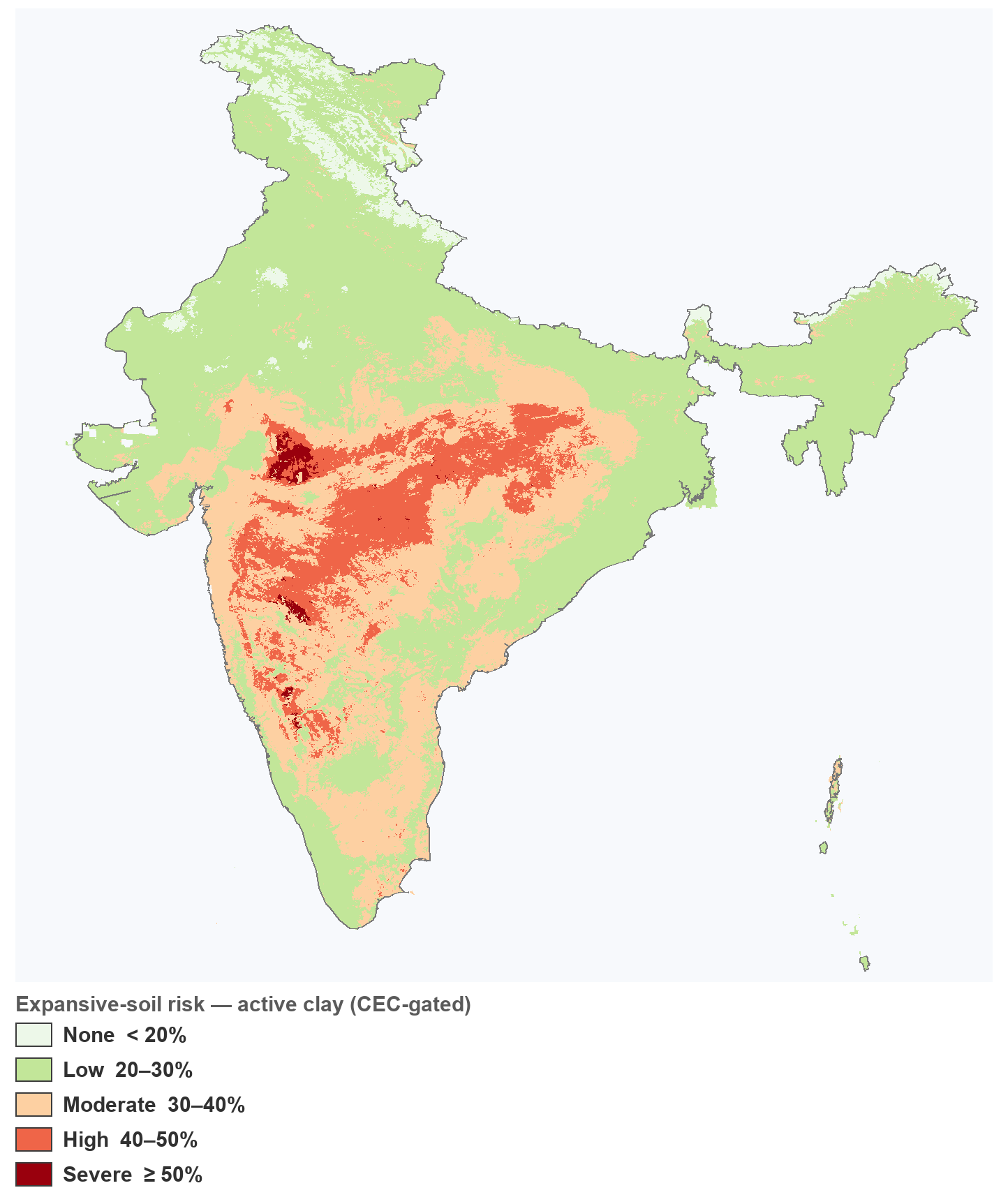
Whether the ground swells and shrinks with the seasons. This is the headline — it is the finding that changes what a foundation costs, and it is decided by the clay’s mineralogy, not its quantity.
Topsoil, foundation zone and deep subsoil, read separately. Clay that thins with depth is harmless; clay that thickens through the footing zone is the expensive case.
Whether standard isolated or strip footings are plausible, or whether the site points to deeper or engineered foundations — with an indicative cost premium.
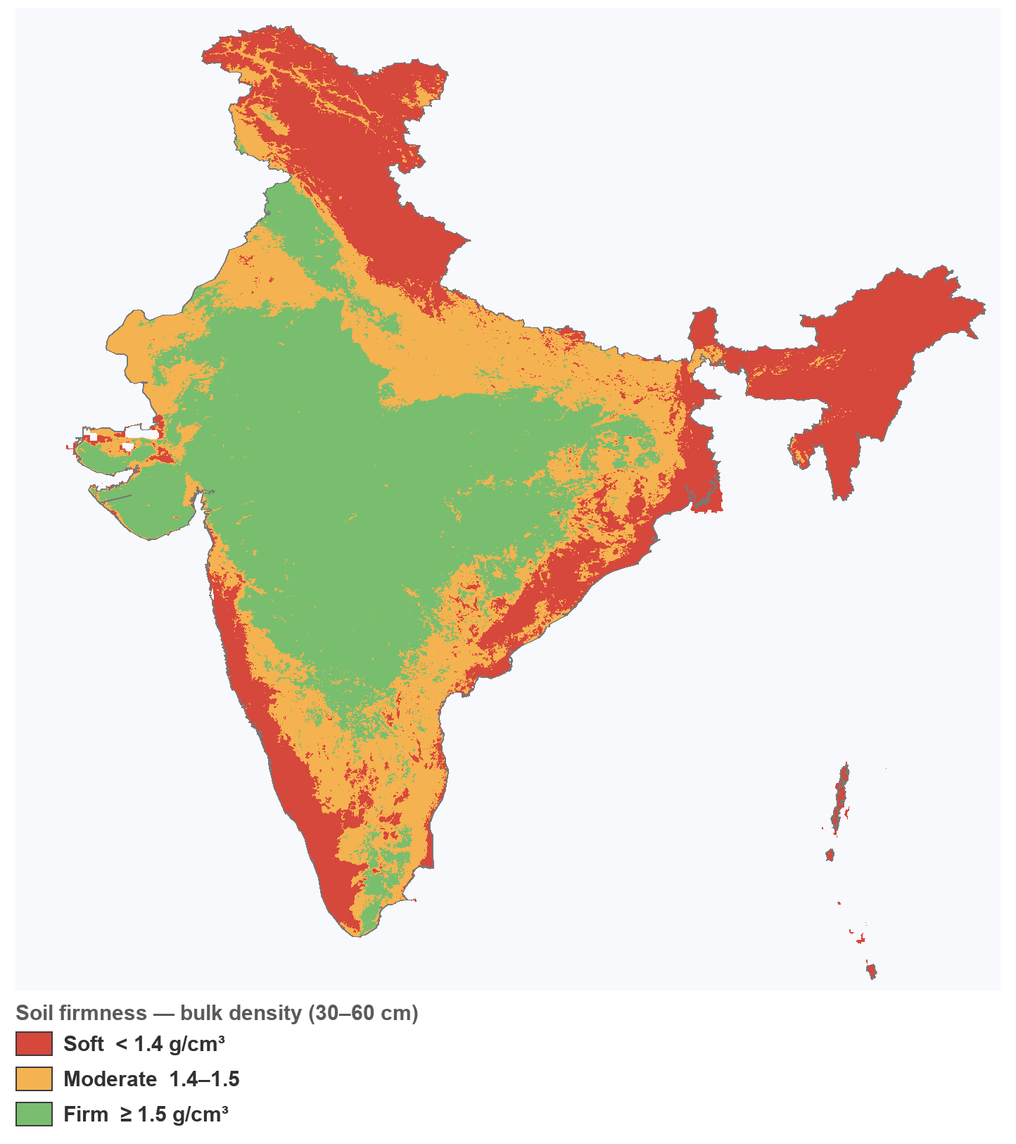
How hard the ground is to dig. This is what prices foundation trenches, sumps, septic tanks and cable runs — and it is invisible at the time of purchase.
Clay percent is not risk
The single most common misreading of a soil report.
Two soils, the same clay percent
A red lateritic soil and a black cotton soil can both read close to 38% clay. One takes standard footings. The other does not.
What separates them is mineralogy
Kaolinitic clay holds its volume as moisture changes. Smectite and montmorillonite clays swell and shrink, and that movement is what cracks a structure.
Clay activity is the indicator
Cation exchange capacity divided by clay content separates the two. It is why this tool reports a risk verdict rather than asking you to read a clay figure.
India’s subsoil at a glance
Two national views of the subsoil, both classified from ISRIC SoilGrids (illustrative — a ~1 km model, not an official soil survey). Left: expansive-soil risk (active clay — clay gated by clay activity, CEC ÷ clay, so swelling black-cotton soil is separated from stable red/kaolinitic clay). Right: soil firmness (bulk density — a firmness proxy, not bearing capacity).
Methodology and data sources
A survey map and a model, kept apart
Soil type, taxonomy, parent material, drainage and depth class come from the ICAR-NBSS&LUP BHOOMI 1:250,000 soil map — the authoritative Indian classification. Chemistry and texture by depth come from ISRIC SoilGrids v2.0 (250 m native, CC BY 4.0), which is a spatial model rather than a survey. The report names which reading came from which, because they do not carry the same weight.
Screening, not a site investigation
SoilGrids predicts at roughly 1 km with an R² around 0.3–0.6 and is nearly depth-flat below 30 cm, so treat these figures as a way to compare plots and budget — never as design inputs. The definitive expansive test is a lab Free Swell Index (IS 2720 Pt 40); safe bearing capacity needs a plate-load test or borehole (IS 6403, IS 1888). Firmness here is a bulk-density proxy, not a bearing value.