Chennai Peripheral Ring Road
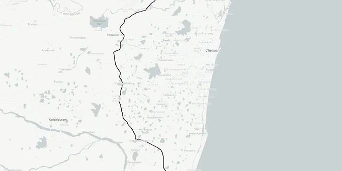
Chennai Peripheral Ring Road Preview
Try the Chennai Peripheral Ring Road on the map
Sign in once and explore the layer for a full day.
- No card details needed
- Find nearby verified lands for sale
Overview
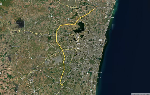
The Chennai Peripheral Ring Road (CPRR) is a 132.87-km, six-lane access-controlled expressway connecting Ennore Port to Poonjeri near Mamallapuram across five sections. Developed by TNRDC under the Tamil Nadu Highways Department, the total project cost is Rs 12,301 crore funded by JICA (Japan International Cooperation Agency), AIIB (Asian Infrastructure Investment Bank), and the OPEC Fund for International Development (OFID). Section 4 (Sriperumbudur to Singaperumalkoil) is complete; Sections 2 and 3 are near completion; Section 4 complete and operational. Sections 2 and 3 nearing completion as of early 2026. Section 5 tender floated December 2025. Section 1 (Ennore to Thatchur) remains the most delayed section; full project completion now expected 2027.
Active Land Acquisition Across 30 Villages: What Chennai Peripheral Ring Road Land Buyers Must Check Before Any Purchase
Land acquisition for the CPRR is still in progress across sections that are not yet complete. Over 234 hectares are being acquired across more than 30 villages, affecting approximately 676 families. Section 1 (Ennore Port to Thatchur, 25.4 km) faces the sharpest delays: relocating 12 water tanks and rerouting heavy power transmission lines are blocking completion. Section 5 (Singaperumalkoil to Mamallapuram, 27.41 km) land acquisition is in its final stage, but tenders have not yet been floated; this section was upgraded from four to six lanes, which also expands the land footprint from the original plan.
The 60-meter ROW is the base corridor. Service road land acquisition is still underway across the entire 132.87-km alignment, meaning the effective footprint is wider than 60 meters in many sections. In stretches where the alignment crosses reserved forest land, TNRDC is processing land swap proposals; plots that border reserved forest areas near the CPRR alignment carry additional legal complexity that standard title verification will not capture.
The table below shows each section, its status, and the current land risk for buyers in adjacent villages:
Section
Stretch
Status
Land Risk
Section 1
Ennore Port to Thatchur (25.4 km)
Under construction; delayed
12 tank + power line relocation pending; service road acquisition underway
Section 2
Thatchur to Tiruvallur Bypass
Under construction
Service road land acquisition in progress
Section 3
Tiruvallur Bypass to Sriperumbudur
79% complete (L&T); 50% (SPK)
Service road land acquisition in progress
Section 4
Sriperumbudur to Singaperumalkoil
Completed
Main ROW settled; service roads ongoing
Section 5
Singaperumalkoil to Mamallapuram (27.41 km)
Land acquisition final stage
Section 5 tender floated by TNRDC in December 2025 (EPC lump-sum model). Construction mobilisation expected 2026; completion now projected 2027. Forest land swap proposal active.
Do not assume that because Section 4 is physically open, adjacent land is free from acquisition risk. Service road land acquisition runs the full length of the corridor; a plot that sits just outside the 60-meter main ROW may still be inside the service road acquisition band. Verify the survey number against the current TNRDC land acquisition notification, not just the main carriageway boundary.
Sriperumbudur to Mamallapuram: Which CPRR Corridors Carry Real Land Investment Value in 2025
Section 4 is the only fully operational section of the CPRR today; it runs through Sriperumbudur, which is already an established electronics and automotive industrial belt. Land there is not priced on future CPRR upside; it is priced on existing industrial demand. The real investment question is where the CPRR adds a new connectivity advantage to areas that were previously harder to access.
The table below shows the primary micro-markets along the CPRR alignment and the realistic land signal at each:
Corridor
Section
Signal
Key Risk
Sriperumbudur (NH-48 junction)
Section 4 (complete)
Active industrial belt; Section 4 operational
Already priced on industrial demand; limited new upside
Singaperumalkoil (ECR junction)
Section 4/5 boundary
CPRR + ECR intersection; growing residential
Verify Section 5 service road land before purchasing
Mamallapuram / Poonjeri (ECR south)
Section 5
Tourism + residential interest; ECR growth
Section 5 tender floated by TNRDC in December 2025 (EPC lump-sum). Construction mobilisation expected 2026; completion projected 2027.
Tiruvallur / NH-716 junction
Sections 2-3
NH-716 + CPRR node; warehouse and logistics demand
Construction disruption ongoing through 2025
Ennore / Kattupalli port fringe
Section 1
Port logistics; industrial corridor
Most delayed section; power line and tank relocation unresolved
Tamaraipakkam / Periyapalayam
Sections 2-3
New connectivity; previously underserved
Service road acquisition in progress; verify before purchase
Singaperumalkoil is the most misread corridor on this alignment. Brokers market it as "Section 4 complete, so uplift is confirmed," but Section 5 (continuing south to Mamallapuram) has not yet reached tender stage; the Singaperumalkoil-to-Mamallapuram land play depends entirely on Section 5 progressing on schedule. The Mamallapuram corridor on the ECR (East Coast Road) is where the speculative premium is highest and also where the timeline is least certain; full completion of Section 5 is expected no earlier than 2026.
Was this layer helpful?
Anything wrong, outdated, or missing we want to hear it.
For Land Owners & Agents
Looking to sell your land in Tamil Nadu?
I want to sell my land in Tamil Nadu
10:32
Plz share your Land's location - We will list it on 1acre map, for Free.
10:32

For Land Buyers
Browse all verified lands & plots in Tamil Nadu
Every listing goes through our Preliminary Verification Process.
More Layers in Tamil Nadu
See all 14 layers
Chennai CMDA Masterplan: Zone Check and Land Use Guide
View Chennai Masterplan as a live map overlay – check any plot's land use zone for free on 1acre.in. Chennai CMDA master...
Chennai Outer Ring Road
View the Chennai Outer Ring Road corridor on a live map overlay – check zoning, approvals and acquisition risk free on 1...
Chennai Port - Maduravoyal Expressway
View Chennai Port - Maduravoyal Expressway alignment as a live map overlay – check land acquisition risk and plot proxim...
More Layers in Tamil Nadu
Chennai CMDA Masterplan: Zone Check and Land Use Guide
View Chennai Masterplan as a live map overlay – check any plot's land use zone for free on 1acre.in. Chennai CMDA master...
Chennai Outer Ring Road
View the Chennai Outer Ring Road corridor on a live map overlay – check zoning, approvals and acquisition risk free on 1...
Chennai Port - Maduravoyal Expressway
View Chennai Port - Maduravoyal Expressway alignment as a live map overlay – check land acquisition risk and plot proxim...