Coimbatore Masterplan 2041: LPA Zone Check and Land Use Guide
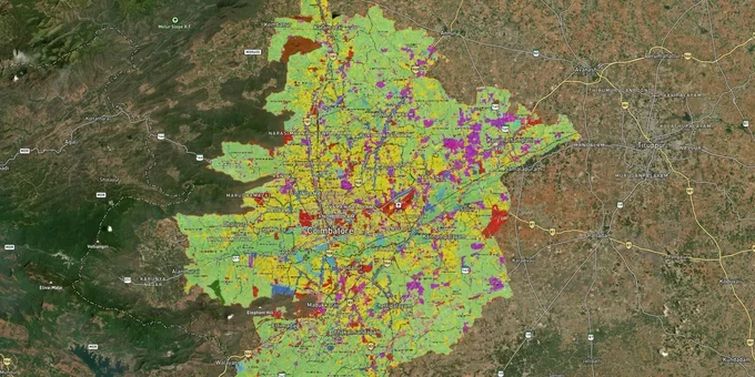
Coimbatore Masterplan Preview
Try the Coimbatore Masterplan 2041 on the map
Sign in once and explore the layer for a full day.
- No card details needed
- Find nearby verified lands for sale
Overview
The Coimbatore masterplan zone land framework is governed by the Coimbatore LPA Masterplan 2041, overseen by the Coimbatore Local Planning Authority (LPA) under the Tamil Nadu Town and Country Planning Act, 1971. The LPA's jurisdiction now covers 1,531.57 sq km across six taluks: Coimbatore South, Perur, Madukkarai, Sulur, Mettupalayam, and Kinathukadavu, spanning one municipal corporation, four municipalities, 21 town panchayats, and 66 revenue villages. The Coimbatore Urban Development Authority (CUDA) operates within this same area. This page covers which approval protects your title, the corridors the masterplan is pushing growth toward, and how to verify both before signing anything.
Vedapatti, Singanallur, Perur: Why "Panchayat Approved" Is the Most Dangerous Phrase in Coimbatore Real Estate
In the Coimbatore LPA area, panchayat-approved layouts account for a disproportionate share of buyer losses. The rule is categorical: under Rule 3 of the Tamil Nadu Panchayat Building Rules, 1997, and DTCP Circular No.9862/10BA1 dated 14 June 2010, no village panchayat has the legal power to sanction a plot layout. A panchayat president's letter, a gift deed registered in the panchayat's name, or a surrender of open space to the panchayat does not constitute a layout approval. Yet plots across Vedapatti, Singanallur fringes, and Perur village panchayat limits have been sold on precisely this basis for decades.
On 21 October 2016, the Madras High Court directed that no registering authority shall register any sale deed for plots in unauthorized layouts. Layouts approved only by panchayats are unauthorized. The table below shows how the three approval categories in the Coimbatore LPA compare against each other.
Approval Type
Issuing Authority
Bank Loan Eligible?
Building Permission Possible?
Risk Level
LPA-approved layout
Coimbatore Local Planning Authority
Yes
Yes, via local body
Low
DTCP-approved layout
Directorate of Town and Country Planning, Tamil Nadu
Yes
Yes, subject to layout conditions
Low
Panchayat approval only
Village panchayat president
No
No
High
In Coimbatore specifically, local authorities in certain peripheral areas have been documented as issuing temporary approvals without fully routing applications through DTCP. This means a layout can carry what looks like an official stamp but still lack the DTCP framework approval that banks and courts require. If the seller cannot produce a layout number from tcp.tn.gov.in or the Coimbatore LPA portal, treat the plot as unverified before any advance is paid.
Western Ring Road Corridor, Saravanampatti and Sulur: Where the Masterplan Is Pulling Land Value
The Coimbatore LPA Masterplan 2041 is explicitly growth-oriented toward the western and northern fringes. The city cannot expand eastward at meaningful scale; Tirupur district limits that direction, and the industrial belt is saturated. The active corridors in the masterplan run southwest (Madukkarai), west (Perur, Madampatti), and northwest (Sulur, Saravanampatti).
The table below maps the corridors that the masterplan's land use designations and infrastructure investments are actively shaping.
Corridor
Masterplan Context
Primary Driver
Known Risk
Madukkarai to Madampatti (Western Ring Road Phase 1)
Mixed: residential expansion zone, Western Bypass alignment
Phase 1 (11.8 km, Madukkarai to Madampatti) near completion as of early 2026; Phase 2 (12.10 km) has no sanctioned funds as of January 2026 — full ring road completion date uncertain
Land acquisition disputes; farmer protests along soil extraction sites
Saravanampatti to Kalapatti
Established residential with IT node designation
Tamil Nadu Industrial Development Corporation Electronics Limited (TIDEL) Park, IT companies, airport proximity (Sulur)
High entry prices; older layouts with pre-LPA panchayat approvals
Sulur to Neelambur
Residential fringe and industrial buffer
Coimbatore International Airport adjacency, proposed Avinashi Road widening
Some SF numbers inside airport influence zone requiring additional No Objection Certificate (NOC)
Mettupalayam corridor (north)
Expansion zone under Mettupalayam taluk
Tourism access to Nilgiris, proposed 4-lane road upgrade
Agricultural land, conversion required for most plots
The most misunderstood corridor is the Western Ring Road land market. Phase 1 (Madukkarai to Madampatti) is over 90% complete but still delayed past its original September 2025 target due to soil shortages, cost escalation, and right-of-way disputes. Sellers along the alignment are pricing in a completed bypass; your due diligence must confirm the actual construction status and, critically, whether the specific SF number falls inside a land acquisition notice under the Tamil Nadu Highways Act, 2001. An acquisition notice voids your development plan entirely.
Was this layer helpful?
Anything wrong, outdated, or missing we want to hear it.
For Land Owners & Agents
Looking to sell your land in Tamil Nadu?
I want to sell my land in Tamil Nadu
10:32
Plz share your Land's location - We will list it on 1acre map, for Free.
10:32

For Land Buyers
Browse all verified lands & plots in Tamil Nadu
Every listing goes through our Preliminary Verification Process.
More Layers in Tamil Nadu
See all 14 layers
Chennai CMDA Masterplan: Zone Check and Land Use Guide
View Chennai Masterplan as a live map overlay – check any plot's land use zone for free on 1acre.in. Chennai CMDA master...

Hosur Masterplan: Zone Check and Land Use Guide
View Hosur Masterplan as a live map overlay – check any plot's land use zone for free on 1acre.in. Hosur masterplan zone...
Chennai Outer Ring Road
View the Chennai Outer Ring Road corridor on a live map overlay – check zoning, approvals and acquisition risk free on 1...
More Layers in Tamil Nadu
Chennai CMDA Masterplan: Zone Check and Land Use Guide
View Chennai Masterplan as a live map overlay – check any plot's land use zone for free on 1acre.in. Chennai CMDA master...
Hosur Masterplan: Zone Check and Land Use Guide
View Hosur Masterplan as a live map overlay – check any plot's land use zone for free on 1acre.in. Hosur masterplan zone...
Chennai Outer Ring Road
View the Chennai Outer Ring Road corridor on a live map overlay – check zoning, approvals and acquisition risk free on 1...