Chennai CMDA Masterplan: Zone Check and Land Use Guide
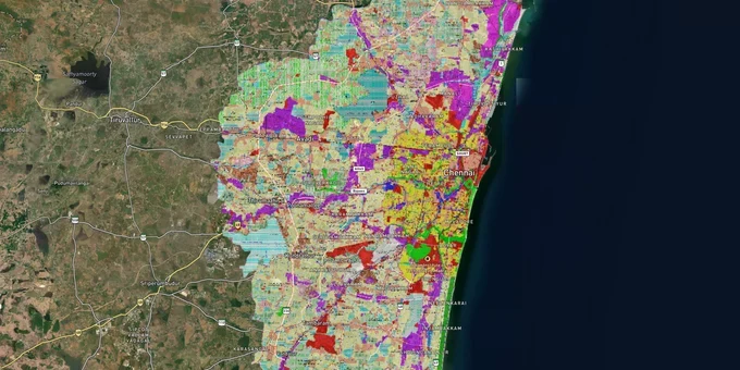
Chennai Masterplan Preview
Try the Chennai CMDA Masterplan on the map
Sign in once and explore the layer for a full day.
- No card details needed
- Find nearby verified lands for sale
Overview
The Chennai CMDA masterplan land zone framework governs all land use across the Chennai Metropolitan Area (CMA), spanning the original 1,189 sq km (the CMA was expanded to 5,904 sq km in October 2022; the Second Master Plan and upcoming Third Master Plan cover the original 1,189 sq km; a Regional Plan will govern the expanded area). Notified in the Tamil Nadu Government Gazette on 2 September 2008, the Second Master Plan 2026 assigns zones including Primary Residential (R1), Mixed Residential, Commercial, Institutional, Industrial, Special and Hazardous Industrial, Agriculture, and Open Space to every parcel within the CMA. The governing authority is the Chennai Metropolitan Development Authority (CMDA), constituted in 1974 under the Tamil Nadu Town and Country Planning Act, 1971. This page covers the zones that kill transactions, the corridors that reflect real demand, and exactly how to verify a parcel before paying anything.
Unapproved Layouts and Agricultural Zone Traps in the Chennai CMDA Masterplan
More land transactions in Chennai collapse at the due diligence stage over zone mismatch and unapproved layout status than any other single cause. The Madras High Court confirmed this is a live enforcement risk, not a theoretical one, as recently as February 2025.
The table below shows the five CMDA zone types where buyers consistently encounter misrepresentation or compliance failures.
Zone
Permitted Use
Requires Reclassification?
Primary Trap
Primary Residential (R1)
Housing: Floor Space Index (FSI) up to 1.5; multi-story up to 2.5/2.75
No, if already R1
Unapproved layout sold as CMDA-approved; patta still held under agricultural classification
Mixed Residential
Housing plus limited commercial on ground floor
No, if correctly zoned
Plots subdivided without CMDA layout approval number
Agriculture Zone (inside CMA)
Farming only
Yes: Change of Land Use (CLU) at 3% of stamp value; clearances from TNPCB, TNHB, CMWSSB, PWD required; gazette notification mandatory
Marketed as "residential with pending conversion"; no gazette notification exists for the parcel
Industrial / Special Industrial
Manufacturing, hazardous industries
Not convertible to residential by CLU
Peripheral industrial plots near Ambattur and Manali marketed as affordable residential investments.
Open Space and Recreational
Parks, playgrounds no construction permitted
Not applicable
Marketed as farmhouse or plotted development; electricity and water connections legally denied
The unapproved layout problem is structural. CMDA's regularization scheme under Government Order (GO) 78 covers only plots registered on or before 31 December 1989. Any seller claiming a post-1989 unapproved plot is eligible for an upcoming scheme should be asked to produce a gazette notification confirming it. None exists as of early 2026. Banks refuse home loans for unapproved layouts. Utility connections are legally withheld. In February 2025, the Madras High Court dismissed Janpriya Builders' petition to regularize seven unauthorized floors in T. Nagar and directed demolition within eight weeks, holding that regularization cannot be claimed as an absolute right (2025:MHC:426). The court specifically noted large-scale official collusion as a reason violations had persisted for over a decade.
For a change of land use reclassification of agricultural land within the CMA, the CMDA process requires Patta, Chitta, Adangal, and a topo plan; agency clearances; placement before the Technical Committee and the Authority; and two publications in the Tamil Nadu Government Gazette. A file submitted to CMDA is not an approval. If a broker cannot show you a gazette notification number for the reclassification, the plot remains agricultural in law.
OMR, Sriperumbudur, and North Chennai: Matching CMDA Masterplan Zones to Corridors That Have Earned Their Prices
Not every corridor in the CMA carries the same infrastructure backing, and the CMDA masterplan designations are specific enough to separate investable zones from speculative ones. Three corridors carry the clearest plan support.
The table below maps the three primary growth corridors to their Second Master Plan 2026 zone designations and confirmed infrastructure anchors.
Corridor
Key Localities
CMDA Masterplan Designation
Infrastructure Anchor
Risk Flag
OMR / Rajiv Gandhi Salai
Taramani, Sholinganallur, Siruseri, Tiruporur
IT/ITeS zone: new residential neighbourhood near Tiruporur designated in Second Master Plan
State Industries Promotion Corporation of Tamil Nadu (SIPCOT) IT Park, 868 acres (Siruseri); Chennai Metro Phase 2 Corridor 3, pile work from Thoraipakkam junction began in January 2024
Plots beyond toll plaza: confirm master plan zone designation before assuming residential classification
GST Road / Western Corridor
Guduvanchery, Sriperumbudur, Irungattukottai, Mahindra World City
Industrial zone (Sriperumbudur belt); new residential town near Sriperumbudur along GWT Road in masterplan
35+ Fortune 500 companies in the Irungattukottai-Sriperumbudur corridor; Mahindra Park SEZ (1,700 acres); 260-acre Aerospace Park at Sriperumbudur with all clearances in place
Plots adjacent to the industrial belt cannot receive residential CLU; verify zone classification independently
North Chennai
Thiruvallur, Gummidipoondi, Ambattur, Manali, Minjur
Satellite town designation (Thiruvallur, Gummidipoondi); industrial urban nodes (Ambattur, Manali) in both Master Plans
Chennai Peripheral Ring Road (CPRR) Section 1 connecting Ennore Port to Thatchur
Industrial-zoned land near Ambattur and Manali routinely marketed as residential; zone must be confirmed parcel by parcel
The most misread corridor is GST Road near Sriperumbudur. The Second Master Plan designates new residential neighborhoods near Sriperumbudur along the western GWT Road, but the industrial belt between Irungattukottai and the main manufacturing clusters carries industrial zone classification. Expecting residential CLU approval on industrial-zoned land is not a planning miscalculation; it is a disqualifying condition. The OMR corridor is better defined: the master plan explicitly designates a new residential neighborhood near Tiruporur, and the SIPCOT IT Park at Siruseri (868 acres) anchors sustained employment demand. The affordable entry pockets now sit past the toll plaza, precisely where zone verification matters most before signing anything.
Was this layer helpful?
Anything wrong, outdated, or missing we want to hear it.
For Land Owners & Agents
Looking to sell your land in Tamil Nadu?
I want to sell my land in Tamil Nadu
10:32
Plz share your Land's location - We will list it on 1acre map, for Free.
10:32

For Land Buyers
Browse all verified lands & plots in Tamil Nadu
Every listing goes through our Preliminary Verification Process.
More Layers in Tamil Nadu
See all 14 layers
Chennai Outer Ring Road
View the Chennai Outer Ring Road corridor on a live map overlay – check zoning, approvals and acquisition risk free on 1...
Chennai Peripheral Ring Road
View Chennai Peripheral Ring Road alignment as a live map overlay – check land acquisition risk and plot proximity free ...
Chennai Port - Maduravoyal Expressway
View Chennai Port - Maduravoyal Expressway alignment as a live map overlay – check land acquisition risk and plot proxim...
More Layers in Tamil Nadu
Chennai Outer Ring Road
View the Chennai Outer Ring Road corridor on a live map overlay – check zoning, approvals and acquisition risk free on 1...
Chennai Peripheral Ring Road
View Chennai Peripheral Ring Road alignment as a live map overlay – check land acquisition risk and plot proximity free ...
Chennai Port - Maduravoyal Expressway
View Chennai Port - Maduravoyal Expressway alignment as a live map overlay – check land acquisition risk and plot proxim...